TopoQuest Logo
Do you find TopoQuest useful?
Help keep TopoQuest running and adding new maps/features by donating!
Bitcoin:  19c7KJd3qBynnjoSw5npx9KScwjBe4ifkT
Litecoin:  LXs6TkuXGGXo1vDsWCkWVdjQX94eUKd6ui
Home View Maps Find Maps Find Places Resources & Links


Marion East, North Carolina Topographic Map

USGS Map Title: Marion East, NC
USGS Map MRC: 35081F8
DRG (GeoTIFF) Download: o35081f8.tif


Neighboring USGS Topographic Map Quads:


  Little Switzerland, NC  
35082G1
 

  Ashford, NC  
35081G8
 

  Oak Hill, NC  
35081G7
 

  Marion West, NC  
35082F1
 

  Marion East, NC  
35081F8
 

  Glen Alpine, NC  
35081F7
 

  Sugar Hill, NC  
35082E1
 

  Glenwood, NC  
35081E8
 

  Dysartsville, NC  
35081E7


Map MRC Location:

N36°
W82°
N36°
W81°
H8 H7 H6 H5 H4 H3 H2 H1
G8 G7 G6 G5 G4 G3 G2 G1
F8 F7 F6 F5 F4 F3 F2 F1
E8 E7 E6 E5 E4 E3 E2 E1
D8 D7 D6 D5 D4 D3 D2 D1
C8 C7 C6 C5 C4 C3 C2 C1
B8 B7 B6 B5 B4 B3 B2 B1
A8 A7 A6 A5 A4 A3 A2 A1
N35°
W82°
N35°
W81°

Marion East, NC USGS 1:24K Topographic Map Preview:
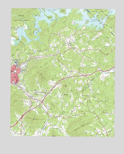
Marion East, NC USGS Topographic Map
Click on map above to begin viewing in our Map Viewer.

This topographic map contains these locations and features:
Feature Name Type Latitude Longitude GNIS ID View Map
Bethel ChurchChurchN35.7090°W81.9576°1009220View Map
Big BranchStreamN35.6979°W81.9487°1009266View Map
Big Camp CreekStreamN35.6701°W81.9162°1009284View Map
Big IslandIslandN35.7412°W81.9546°1009327View Map
Black Bear CoveBayN35.7485°W81.9640°1009429View Map
Bledsoe BranchStreamN35.6540°W81.9373°1009474View Map
Bobs CreekStreamN35.6371°W81.9437°1009521View Map
Caleb BranchStreamN35.6635°W81.9182°1009908View Map
Canal BridgeBridgeN35.7437°W81.8843°1009992View Map
Catawba River DamDamN35.7340°W81.8893°1010098View Map
Central ChurchChurchN35.6710°W81.9854°1010149View Map
Chapel Hill ChurchChurchN35.6576°W81.9754°1010169View Map
ClinchfieldPopulated PlaceN35.6990°W81.9915°1010328View Map
Conley ChapelChurchN35.7085°W81.9665°1010438View Map
Dixon CemeteryCemeteryN35.6510°W81.8859°1010834View Map
Drusilla ChurchChurchN35.6296°W81.8823°1010907View Map
Dysartsville ChurchChurchN35.6354°W81.8887°1010957View Map
Dysartsville Volunteer Fire DepartmentBuildingN35.6328°W81.8865°2639300View Map
East MarionPopulated PlaceN35.6843°W81.9918°1020086View Map
Fairview ChurchChurchN35.6887°W81.9265°1011137View Map
Ferguson BranchStreamN35.6696°W81.9023°1011198View Map
Forsyth CreekStreamN35.7168°W81.9782°1011342View Map
Gibbs MountainSummitN35.6815°W81.9618°1011478View Map
Grant MountainSummitN35.6590°W81.9937°1011609View Map
Hall CemeteryCemeteryN35.7293°W81.9937°1011799View Map
Haney CemeteryCemeteryN35.6296°W81.9398°1011832View Map
Hankins - North Fork Volunteer Fire DepartmentBuildingN35.7309°W81.9989°2639299View Map
Harmony Grove ChurchChurchN35.6651°W81.9076°1011864View Map
Hemphill CreekStreamN35.6940°W81.8970°1011964View Map
Hicks Memorial ChurchChurchN35.6657°W81.9359°1012029View Map
Higgins MountainSummitN35.6351°W81.9137°1012035View Map
Hoover CemeteryCemeteryN35.6615°W81.9754°1012166View Map
Huckleberry BranchStreamN35.6546°W81.9315°1012245View Map
JacktownPopulated PlaceN35.6679°W81.9679°1020927View Map
Jacktown CreekStreamN35.6521°W81.9587°1012414View Map
Jamison MountainSummitN35.6548°W81.9487°1023706View Map
Lake JamesReservoirN35.7376°W81.9529°1012434View Map
Lake James State ParkParkN35.7358°W81.8792°2374757View Map
Large BranchStreamN35.6371°W81.8818°1012684View Map
Little Camp CreekStreamN35.6846°W81.9307°1012925View Map
Little MountainSummitN35.6501°W81.9173°1012992View Map
Marion Correctional institutionBuildingN35.6404°W81.9468°2769839View Map
Marion Country ClubLocaleN35.7368°W81.9087°1013325View Map
Mcdowell High SchoolSchoolN35.6896°W81.9959°1017638View Map
McDowell Memorial ParkCemeteryN35.7043°W81.9773°1013420View Map
NeboPopulated PlaceN35.7151°W81.9309°1013886View Map
Nebo CemeteryCemeteryN35.7157°W81.9223°1013887View Map
Nebo Elementary SchoolSchoolN35.6840°W81.9926°1023709View Map
Nebo Post OfficePost OfficeN35.7135°W81.9293°2773900View Map
Nebo Volunteer Fire DepartmentBuildingN35.7214°W81.9402°2639395View Map
Neighbors BranchStreamN35.6665°W81.9020°1013898View Map
Nix BranchStreamN35.7148°W81.8759°1013965View Map
North Carolina State Prison CampLocaleN35.6518°W81.9540°1017983View Map
North Fork Catawba RiverStreamN35.7290°W81.9840°1024192View Map
Oak Grove CemeteryCemeteryN35.6771°W81.9965°1014051View Map
Paddy CreekStreamN35.7490°W81.8804°1014173View Map
Parkers ChapelChurchN35.6679°W81.9679°1014228View Map
Pleasant Gardens Volunteer Fire DepartmentBuildingN35.7015°W81.9683°2639391View Map
Pleasant Hill ChurchChurchN35.6679°W81.9579°1014525View Map
Reedy MountainSummitN35.6740°W81.9348°1014811View Map
Rocky Pass CemeteryCemeteryN35.6493°W81.9254°1015050View Map
Rocky Pass ChurchChurchN35.6443°W81.9293°1015051View Map
Rolands ChapelChurchN35.7123°W81.9501°1015077View Map
Saint Johns ChurchChurchN35.7057°W81.8840°1015158View Map
Shehan BranchStreamN35.7062°W81.9409°1015404View Map
Smith MountainSummitN35.6410°W81.9712°1015615View Map
South Marion ChurchChurchN35.6657°W81.9662°1015702View Map
Structure Number EightDamN35.7018°W81.9148°1017274View Map
Structure Number Eight LakeReservoirN35.6970°W81.9171°1017273View Map
StumptownPopulated PlaceN35.6901°W81.9846°1022822View Map
Sunny Grove ChurchChurchN35.6271°W81.8959°1015955View Map
Taylor Lake DamDamN35.6468°W81.9682°1017264View Map
Taylors LakeReservoirN35.6480°W81.9683°1017265View Map
Thompsons ForkStreamN35.6882°W81.8904°1016126View Map
Township of HigginsCivilN35.6527°W81.9340°1026895View Map
Township of NeboCivilN35.7301°W81.9304°1026898View Map
Walton Crawley BranchStreamN35.6748°W81.9059°1016437View Map
WBRM-AM (Marion)TowerN35.7018°W81.9804°1018479View Map
West McDowell Junior High SchoolSchoolN35.6926°W81.9923°1017631View Map
White BranchStreamN35.6557°W81.9254°1016580View Map
Youngs ForkStreamN35.6443°W81.9404°1024417View Map

Note: Coordinates in the location and feature list above are referenced to NAD83 datum.


Copyright (C) 2008-2024 Ryan Niemi / Sunset Dynamics ... All Rights Reserved