TopoQuest Logo
Do you find TopoQuest useful?
Help keep TopoQuest running and adding new maps/features by donating!
Bitcoin:  19c7KJd3qBynnjoSw5npx9KScwjBe4ifkT
Litecoin:  LXs6TkuXGGXo1vDsWCkWVdjQX94eUKd6ui
Home View Maps Find Maps Find Places Resources & Links


Ochlocknee, Georgia Topographic Map

USGS Map Title: Ochlocknee, GA
USGS Map MRC: 30084H1
DRG (GeoTIFF) Download: o30084h1.tif


Neighboring USGS Topographic Map Quads:


  Pelham, GA  
31084A2
 

  Meigs, GA  
31084A1
 

  Chastain, GA  
31083A8
 

  Cairo North, GA  
30084H2
 

  Ochlocknee, GA  
30084H1
 

  Merrillville, GA  
30083H8
 

  Cairo South, GA  
30084G2
 

  Pine Park, GA  
30084G1
 

  Thomasville, GA  
30083G8


Map MRC Location:

N31°
W85°
N31°
W84°
H8 H7 H6 H5 H4 H3 H2 H1
G8 G7 G6 G5 G4 G3 G2 G1
F8 F7 F6 F5 F4 F3 F2 F1
E8 E7 E6 E5 E4 E3 E2 E1
D8 D7 D6 D5 D4 D3 D2 D1
C8 C7 C6 C5 C4 C3 C2 C1
B8 B7 B6 B5 B4 B3 B2 B1
A8 A7 A6 A5 A4 A3 A2 A1
N30°
W85°
N30°
W84°

Ochlocknee, GA USGS 1:24K Topographic Map Preview:
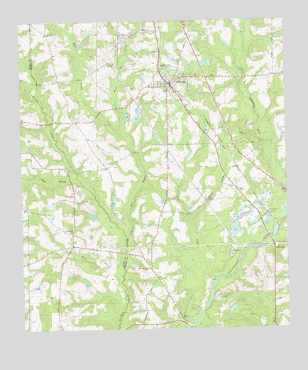
Ochlocknee, GA USGS Topographic Map
Click on map above to begin viewing in our Map Viewer.

This topographic map contains these locations and features:
Feature Name Type Latitude Longitude GNIS ID View Map
Arbordale ChurchChurchN30.9466°W84.1196°334678View Map
Barnetts Creek CemeteryCemeteryN30.8996°W84.0663°343681View Map
Barnetts Creek ChurchChurchN30.8996°W84.0655°354467View Map
Barnetts Creek Volunteer Fire Department Station 6BuildingN30.8994°W84.0646°2604808View Map
Beverly LakeReservoirN30.9830°W84.0365°342107View Map
Beverly Lake DamDamN30.9819°W84.0349°342106View Map
Bold Springs CemeteryCemeteryN30.9146°W84.1021°342449View Map
Bold Springs ChurchChurchN30.9146°W84.1013°354807View Map
Bryan BranchStreamN30.8969°W84.0777°311929View Map
Bullock Mill (historical)LocaleN30.9807°W84.0768°343696View Map
Children Center SchoolSchoolN30.9819°W84.0571°355150View Map
Dawes ChapelChurchN30.9313°W84.0221°313366View Map
DawesvillePopulated PlaceN30.9224°W84.0091°331526View Map
East Branch Barnetts CreekStreamN30.9132°W84.0760°313769View Map
Hadley CemeteryCemeteryN30.8813°W84.0493°343737View Map
Hadley ChurchChurchN30.8805°W84.0491°356135View Map
Hendry CemeteryCemeteryN30.9538°W84.0191°356261View Map
Horse CreekStreamN30.9538°W84.0743°315685View Map
Jones CemeteryCemeteryN30.9957°W84.0407°343742View Map
Maranatha ChurchChurchN30.9696°W84.0691°343753View Map
Montgomery CemeteryCemeteryN30.9294°W84.1002°318403View Map
Mount Nebo CemeteryCemeteryN30.8885°W84.1132°342503View Map
Mount Nebo ChurchChurchN30.8885°W84.1127°318706View Map
Mount Phisby ChurchChurchN30.9766°W84.0185°334732View Map
OchlockneePopulated PlaceN30.9738°W84.0530°356440View Map
Ochlocknee CemeteryCemeteryN30.9802°W84.0471°334733View Map
Ochlocknee DivisionCivilN30.9639°W84.0290°1936450View Map
Ochlocknee Fire Department Station 8BuildingN30.9719°W84.0515°2603922View Map
Ochlocknee Post OfficePost OfficeN30.9743°W84.0558°2767399View Map
Pine CreekStreamN30.8955°W84.0332°320546View Map
Roddenberry Camp (historical)LocaleN30.8835°W84.0332°343803View Map
Scullys Store (historical)LocaleN30.9763°W84.1066°343819View Map
Singletary CemeteryCemeteryN30.9266°W84.0968°342536View Map
Singletary Cemetery Number 1CemeteryN30.9410°W84.0813°343824View Map
Singletary LakeReservoirN30.9610°W84.0699°342103View Map
Singletary LakeReservoirN30.9625°W84.0680°342105View Map
Singletary Lake DamDamN30.9635°W84.0682°342104View Map
Singletary Lake Dam Number ThreeDamN30.9619°W84.0749°344412View Map
Singletary Lake Dam Number TwoDamN30.9602°W84.0699°344411View Map
Singletary Lake Number ThreeReservoirN30.9615°W84.0744°344413View Map
Spring Hill ChurchChurchN30.9955°W84.1118°323412View Map
Spring Hill School (historical)SchoolN30.9952°W84.1118°343827View Map
Springhill CemeteryCemeteryN30.9957°W84.1118°343830View Map
Town of OchlockneeCivilN30.9752°W84.0518°2407034View Map
Union School (historical)SchoolN30.9032°W84.1216°334683View Map
Walden CemeteryCemeteryN30.9427°W84.0810°324754View Map
Wesleyan Church (historical)ChurchN30.9219°W84.1135°342549View Map
West Branch Barnetts CreekStreamN30.9352°W84.0971°325038View Map
Wilson BranchStreamN30.9191°W84.0443°325420View Map

Note: Coordinates in the location and feature list above are referenced to NAD83 datum.


Copyright (C) 2008-2024 Ryan Niemi / Sunset Dynamics ... All Rights Reserved