TopoQuest Logo
Do you find TopoQuest useful?
Help keep TopoQuest running and adding new maps/features by donating!
Bitcoin:  19c7KJd3qBynnjoSw5npx9KScwjBe4ifkT
Litecoin:  LXs6TkuXGGXo1vDsWCkWVdjQX94eUKd6ui
Home View Maps Find Maps Find Places Resources & Links


Cow Hell Swamp, Georgia Topographic Map

USGS Map Title: Cow Hell Swamp, GA
USGS Map MRC: 32082F8
DRG (GeoTIFF) Download: o32082f8.tif


Neighboring USGS Topographic Map Quads:


  Toomsboro, GA  
32083G1
 

  Oconee, GA  
32082G8
 

  Irwins Crossroads, GA  
32082G7
 

  Nicklesville, GA  
32083F1
 

  Cow Hell Swamp, GA  
32082F8
 

  Lovett, GA  
32082F7
 

  Dudley, GA  
32083E1
 

  Dublin, GA  
32082E8
 

  East Dublin, GA  
32082E7


Map MRC Location:

N33°
W83°
N33°
W82°
H8 H7 H6 H5 H4 H3 H2 H1
G8 G7 G6 G5 G4 G3 G2 G1
F8 F7 F6 F5 F4 F3 F2 F1
E8 E7 E6 E5 E4 E3 E2 E1
D8 D7 D6 D5 D4 D3 D2 D1
C8 C7 C6 C5 C4 C3 C2 C1
B8 B7 B6 B5 B4 B3 B2 B1
A8 A7 A6 A5 A4 A3 A2 A1
N32°
W83°
N32°
W82°

Cow Hell Swamp, GA USGS 1:24K Topographic Map Preview:
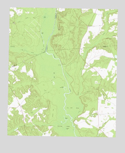
Cow Hell Swamp, GA USGS Topographic Map
Click on map above to begin viewing in our Map Viewer.

This topographic map contains these locations and features:
Feature Name Type Latitude Longitude GNIS ID View Map
Beaverdam SwampSwampN32.6598°W82.9407°311011View Map
Big Sandy CreekStreamN32.7107°W82.9568°311407View Map
Bowens LakeLakeN32.6384°W82.9346°311675View Map
Buckeye CreekStreamN32.6627°W82.9326°354899View Map
Chinaberry Ranch AirportAirportN32.6945°W82.9003°2646206View Map
Clear LakeLakeN32.6865°W82.9483°312724View Map
Cow Hell SwampSwampN32.6532°W82.9238°313051View Map
Cullen Grove ChurchChurchN32.7021°W82.8754°355401View Map
Cullens Store (historical)LocaleN32.6774°W82.8940°346521View Map
Deep CreekStreamN32.6349°W82.9718°313408View Map
Deep CreekStreamN32.6943°W82.9385°313409View Map
Deep Creek LandingLocaleN32.6935°W82.9379°346524View Map
Dry CreekStreamN32.6677°W82.9346°313672View Map
Evergreen ChurchChurchN32.6535°W82.9843°355743View Map
Flat CreekStreamN32.6402°W82.9251°314174View Map
Fords CreekStreamN32.7232°W82.8918°355865View Map
Gin BranchStreamN32.6707°W82.9915°314611View Map
Gin BranchStreamN32.7488°W82.8774°314612View Map
Goat PondLakeN32.7307°W82.9424°314661View Map
Goose CreekStreamN32.7410°W82.9799°314699View Map
Guyton CemeteryCemeteryN32.6493°W82.8965°314993View Map
Hall LandingLocaleN32.7077°W82.9574°346547View Map
Halls LandingLocaleN32.7040°W82.9671°331900View Map
Herberts ChapelChurchN32.7332°W82.9090°356266View Map
Hightower CemeteryCemeteryN32.7213°W82.8843°315400View Map
Holly Grove CemeteryCemeteryN32.6274°W82.9576°315555View Map
Holly Springs ChurchChurchN32.6666°W82.8926°315570View Map
Jack LakeLakeN32.6828°W82.9482°315985View Map
Kellams CemeteryCemeteryN32.6729°W82.8968°316347View Map
Kellams CreekStreamN32.6663°W82.9185°316348View Map
Little Sandy CreekStreamN32.7115°W82.9585°317182View Map
Londonfield CemeteryCemeteryN32.6540°W82.8876°317299View Map
Messers BridgeBridgeN32.7118°W82.9979°318051View Map
Moody CemeteryCemeteryN32.7210°W82.9096°318415View Map
Old Evergreen School (historical)SchoolN32.6885°W82.9924°346601View Map
Plummer CemeteryCemeteryN32.6943°W82.9096°320951View Map
Post CemeteryCemeteryN32.7107°W82.9176°321085View Map
Salem CemeteryCemeteryN32.7352°W82.9943°346814View Map
Salem ChurchChurchN32.7346°W82.9943°322357View Map
Sarchett LakeLakeN32.6322°W82.9344°322524View Map
Stanley CemeteryCemeteryN32.6477°W82.9729°323512View Map
Tobe LakeLakeN32.7412°W82.9584°324202View Map
Tuckers FlatFlatN32.6485°W82.9476°324352View Map
Walker CemeteryCemeteryN32.6332°W82.8901°324769View Map
Wynn LakeLakeN32.7235°W82.9622°325591View Map
Yorks Dead RiverLakeN32.6732°W82.9339°325631View Map

Note: Coordinates in the location and feature list above are referenced to NAD83 datum.


Copyright (C) 2008-2024 Ryan Niemi / Sunset Dynamics ... All Rights Reserved