TopoQuest Logo
Do you find TopoQuest useful?
Help keep TopoQuest running and adding new maps/features by donating!
Bitcoin:  19c7KJd3qBynnjoSw5npx9KScwjBe4ifkT
Litecoin:  LXs6TkuXGGXo1vDsWCkWVdjQX94eUKd6ui
Home View Maps Find Maps Find Places Resources & Links


Ben Lomond, Arkansas Topographic Map

USGS Map Title: Ben Lomond, AR
USGS Map MRC: 33094G1
DRG (GeoTIFF) Download: o33094g1.tif


Neighboring USGS Topographic Map Quads:


  Lockesburg, AR  
33094H2
 

  Silver Ridge, AR  
33094H1
 

  Mineral Springs North, AR  
33093H8
 

  Falls Chapel, AR  
33094G2
 

  Ben Lomond, AR  
33094G1
 

  Mineral Springs South, AR  
33093G8
 

  Ashdown West, AR  
33094F2
 

  Ashdown East, AR  
33094F1
 

  Red Bluff, AR  
33093F8


Map MRC Location:

N34°
W95°
N34°
W94°
H8 H7 H6 H5 H4 H3 H2 H1
G8 G7 G6 G5 G4 G3 G2 G1
F8 F7 F6 F5 F4 F3 F2 F1
E8 E7 E6 E5 E4 E3 E2 E1
D8 D7 D6 D5 D4 D3 D2 D1
C8 C7 C6 C5 C4 C3 C2 C1
B8 B7 B6 B5 B4 B3 B2 B1
A8 A7 A6 A5 A4 A3 A2 A1
N33°
W95°
N33°
W94°

Ben Lomond, AR USGS 1:24K Topographic Map Preview:
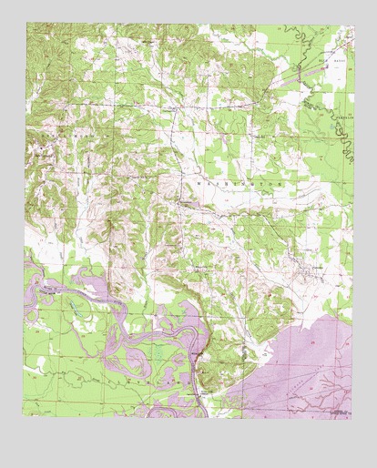
Ben Lomond, AR USGS Topographic Map
Click on map above to begin viewing in our Map Viewer.

This topographic map contains these locations and features:
Feature Name Type Latitude Longitude GNIS ID View Map
Ben LomondPopulated PlaceN33.8354°W94.1185°76301View Map
Ben Lomond CemeteryCemeteryN33.8248°W94.1157°67310View Map
Ben Lomond Post OfficePost OfficeN33.8361°W94.1156°2740753View Map
Ben Lomond Volunteer Fire DepartmentBuildingN33.8353°W94.1191°2116131View Map
Big SloughGutN33.7646°W94.1074°46601View Map
Blacks BranchStreamN33.7810°W94.0785°46692View Map
Blacks BranchStreamN33.7815°W94.0188°46693View Map
Blue BayouStreamN33.8554°W94.0163°46737View Map
Browns CreekStreamN33.7957°W94.0994°47022View Map
BrownstownPopulated PlaceN33.8179°W94.0671°76433View Map
Brownstown CemeteryCemeteryN33.8048°W94.0663°47027View Map
Brownstown Community ChurchChurchN33.8171°W94.0663°67311View Map
Cook BranchStreamN33.8723°W94.0144°47973View Map
Cornhill (historical)Populated PlaceN33.8543°W94.0341°67313View Map
Corns Bridge (historical)BridgeN33.8610°W94.0213°62560View Map
Coulter BranchStreamN33.7776°W94.0274°76687View Map
CowlingsvillePopulated PlaceN33.8485°W94.0680°56973View Map
Davis SloughStreamN33.7910°W94.1185°48396View Map
Grassy LakeLakeN33.7843°W94.1051°74861View Map
Gravelly Hill ChurchChurchN33.8265°W94.0852°49594View Map
Graves SchoolSchoolN33.8398°W94.0385°49601View Map
Lake HospitalityReservoirN33.8201°W94.0585°80685View Map
Lake Hospitality DamDamN33.8201°W94.0585°80684View Map
ParalomaPopulated PlaceN33.7979°W94.0191°58324View Map
Parloma LandingLocaleN33.7823°W94.0057°67312View Map
Sand CreekStreamN33.8607°W94.0219°54533View Map
Sand SloughStreamN33.7929°W94.1069°54544View Map
ShilohPopulated PlaceN33.8710°W94.0005°58615View Map
Starch CreekStreamN33.8685°W94.0174°55163View Map
Town of Ben LomondCivilN33.8337°W94.1176°2405240View Map
Township of Ben LomondCivilN33.8509°W94.1178°69123View Map
Township of WashingtonCivilN33.8211°W94.0370°69133View Map
Trout LakeLakeN33.7737°W94.1032°60182View Map
White CliffsPopulated PlaceN33.7971°W94.0602°78747View Map
White Cliffs Public Use AreaParkN33.7607°W94.0585°60186View Map
White Cliffs SchoolSchoolN33.7693°W94.0569°56253View Map
White Cliffs StationLocaleN33.7573°W94.0574°56254View Map
Wrights ChapelChurchN33.8687°W94.0782°54008View Map
Wrights Chapel CemeteryCemeteryN33.8748°W94.0885°54005View Map

Note: Coordinates in the location and feature list above are referenced to NAD83 datum.


Copyright (C) 2008-2024 Ryan Niemi / Sunset Dynamics ... All Rights Reserved