TopoQuest Logo
Do you find TopoQuest useful?
Help keep TopoQuest running and adding new maps/features by donating!
Bitcoin:  19c7KJd3qBynnjoSw5npx9KScwjBe4ifkT
Litecoin:  LXs6TkuXGGXo1vDsWCkWVdjQX94eUKd6ui
Home View Maps Find Maps Find Places Resources & Links


Mineral Springs South, Arkansas Topographic Map

USGS Map Title: Mineral Springs South, AR
USGS Map MRC: 33093G8
DRG (GeoTIFF) Download: o33093g8.tif


Neighboring USGS Topographic Map Quads:


  Silver Ridge, AR  
33094H1
 

  Mineral Springs North, AR  
33093H8
 

  Nashville, AR  
33093H7
 

  Ben Lomond, AR  
33094G1
 

  Mineral Springs South, AR  
33093G8
 

  Columbus, AR  
33093G7
 

  Ashdown East, AR  
33094F1
 

  Red Bluff, AR  
33093F8
 

  McNab, AR  
33093F7


Map MRC Location:

N34°
W94°
N34°
W93°
H8 H7 H6 H5 H4 H3 H2 H1
G8 G7 G6 G5 G4 G3 G2 G1
F8 F7 F6 F5 F4 F3 F2 F1
E8 E7 E6 E5 E4 E3 E2 E1
D8 D7 D6 D5 D4 D3 D2 D1
C8 C7 C6 C5 C4 C3 C2 C1
B8 B7 B6 B5 B4 B3 B2 B1
A8 A7 A6 A5 A4 A3 A2 A1
N33°
W94°
N33°
W93°

Mineral Springs South, AR USGS 1:24K Topographic Map Preview:
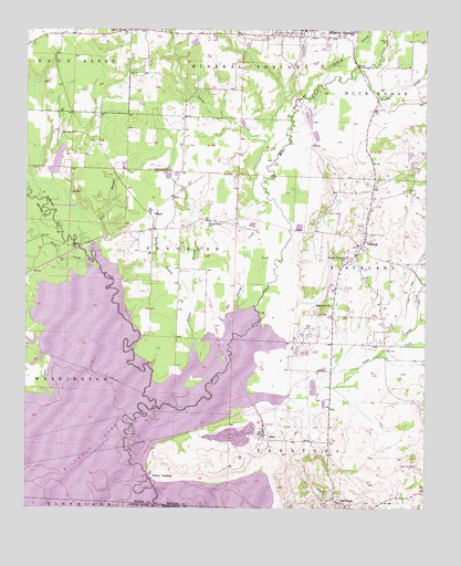
Mineral Springs South, AR USGS Topographic Map
Click on map above to begin viewing in our Map Viewer.

This topographic map contains these locations and features:
Feature Name Type Latitude Longitude GNIS ID View Map
AllbrookPopulated PlaceN33.8001°W93.8888°62517View Map
Baber CreekStreamN33.7929°W93.8841°45994View Map
Blackland ChurchChurchN33.8032°W93.9044°46689View Map
Blackland Church (historical)ChurchN33.7932°W93.8996°62535View Map
Bright Star ChurchChurchN33.8251°W93.9430°46955View Map
Brushy CreekStreamN33.8626°W93.8985°47073View Map
Bucky Range School (historical)SchoolN33.8343°W93.8791°62547View Map
Cottonshed LandingLocaleN33.7918°W93.9660°67273View Map
Cottonshed Landing Use AreaParkN33.7912°W93.9660°62561View Map
Cottonshed Volunteer Fire DepartmentBuildingN33.8061°W93.9627°2116313View Map
Crofton Academy (historical)SchoolN33.8282°W93.9055°62565View Map
Crofton CemeteryCemeteryN33.8276°W93.9063°48164View Map
Devils BackboneRidgeN33.7579°W93.9196°62568View Map
Dillard CreekStreamN33.8607°W93.9082°48518View Map
Hickory Grove Church (historical)ChurchN33.8359°W93.8855°62598View Map
Hickory Grove School (historical)SchoolN33.8368°W93.8910°62599View Map
High Hill CemeteryCemeteryN33.7612°W93.8777°50100View Map
Hosey BranchStreamN33.8062°W93.9494°50351View Map
Howard County High School (historical)SchoolN33.8160°W93.8999°62604View Map
Ingram CreekStreamN33.7957°W93.9355°50510View Map
Kever LakeReservoirN33.8718°W93.9477°81020View Map
Kever Lake DamDamN33.8718°W93.9469°81019View Map
Mine CreekStreamN33.7757°W93.9605°52086View Map
Mineral Springs Volunteer Fire StationBuildingN33.8748°W93.9220°2116801View Map
Negro BranchStreamN33.8179°W93.9835°52595View Map
OkayPopulated PlaceN33.7676°W93.9241°58299View Map
Okay DikeLeveeN33.7821°W93.9321°62640View Map
Okay Dike Use AreaParkN33.7765°W93.9280°62641View Map
Okay School (historical)SchoolN33.7665°W93.9221°62642View Map
Plum CreekStreamN33.7796°W93.9182°53628View Map
Saline LandingLocaleN33.7585°W93.9613°58576View Map
Saline Landing Bridge (historical)BridgeN33.7587°W93.9621°62671View Map
SaratogaPopulated PlaceN33.7518°W93.9027°58589View Map
Saratoga Post OfficePost OfficeN33.7518°W93.9024°84224View Map
Saratoga Volunteer Fire DepartmentBuildingN33.7520°W93.9044°2117094View Map
SchaalPopulated PlaceN33.8262°W93.9610°67104View Map
SchaalLocaleN33.8262°W93.9610°54612View Map
Schaal BranchStreamN33.7912°W93.9469°54613View Map
Schaal School (historical)SchoolN33.8243°W93.9549°62675View Map
Scotty LakeReservoirN33.8409°W93.9904°80667View Map
Scotty Lake DamDamN33.8368°W93.9919°80666View Map
Shiloh ChurchChurchN33.8748°W93.9707°54788View Map
Shiloh School (historical)SchoolN33.8743°W93.9707°62679View Map
Shirley CemeteryCemeteryN33.7996°W93.8924°62681View Map
Steel Bridge (historical)BridgeN33.8176°W93.9835°62684View Map
Tabernacle ChurchChurchN33.8382°W93.9552°55415View Map
TollettePopulated PlaceN33.8198°W93.8944°58751View Map
Tollette Volunteer Fire DepartmentBuildingN33.8154°W93.8995°2117215View Map
Town of TolletteCivilN33.8181°W93.8971°2406741View Map
Township of BlacklandCivilN33.8136°W93.8754°66671View Map
Township of FranklinCivilN33.8240°W93.9578°66682View Map
Township of Mineral SpringsCivilN33.8688°W93.9342°66685View Map
Township of SaratogaCivilN33.7700°W93.8934°66690View Map
Township of TolletteCivilN33.8181°W93.8971°66935View Map
Trent CreekStreamN33.8157°W93.9813°55644View Map
Wood Side BridgeBridgeN33.8187°W93.9852°67320View Map

Note: Coordinates in the location and feature list above are referenced to NAD83 datum.


Copyright (C) 2008-2025 Ryan Niemi / Sunset Dynamics ... All Rights Reserved