TopoQuest Logo
Do you find TopoQuest useful?
Help keep TopoQuest running and adding new maps/features by donating!
Bitcoin:  19c7KJd3qBynnjoSw5npx9KScwjBe4ifkT
Litecoin:  LXs6TkuXGGXo1vDsWCkWVdjQX94eUKd6ui
Home View Maps Find Maps Find Places Resources & Links


Ofelia, Alabama Topographic Map

USGS Map Title: Ofelia, AL
USGS Map MRC: 33085C5
DRG (GeoTIFF) Download: o33085c5.tif


Neighboring USGS Topographic Map Quads:


  Delta, AL  
33085D6
 

  Micaville, AL  
33085D5
 

  Newell, AL  
33085D4
 

  Lineville East, AL  
33085C6
 

  Ofelia, AL  
33085C5
 

  Wedowee, AL  
33085C4
 

  Mellow Valley, AL  
33085B6
 

  Wadley North, AL  
33085B5
 

  Roanoke West, AL  
33085B4


Map MRC Location:

N34°
W86°
N34°
W85°
H8 H7 H6 H5 H4 H3 H2 H1
G8 G7 G6 G5 G4 G3 G2 G1
F8 F7 F6 F5 F4 F3 F2 F1
E8 E7 E6 E5 E4 E3 E2 E1
D8 D7 D6 D5 D4 D3 D2 D1
C8 C7 C6 C5 C4 C3 C2 C1
B8 B7 B6 B5 B4 B3 B2 B1
A8 A7 A6 A5 A4 A3 A2 A1
N33°
W86°
N33°
W85°

Ofelia, AL USGS 1:24K Topographic Map Preview:
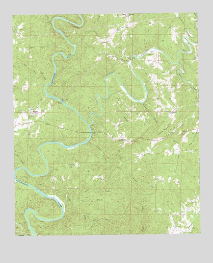
Ofelia, AL USGS Topographic Map
Click on map above to begin viewing in our Map Viewer.

This topographic map contains these locations and features:
Feature Name Type Latitude Longitude GNIS ID View Map
Allen BranchStreamN33.3304°W85.5611°112994View Map
Andanley BranchStreamN33.3246°W85.5383°113065View Map
Auslin ChapelChurchN33.2896°W85.5877°164021View Map
Bethel West ChurchChurchN33.3740°W85.5469°114096View Map
Blake Ferry (historical)CrossingN33.2815°W85.6205°140193View Map
Boozer CemeteryCemeteryN33.2957°W85.5086°140194View Map
Brown Ford (historical)CrossingN33.3368°W85.5622°140195View Map
Buck BranchStreamN33.2504°W85.5397°115102View Map
Burrow Ferry (historical)CrossingN33.3121°W85.5741°155423View Map
Butlers Ferry (historical)CrossingN33.3526°W85.5858°154378View Map
Cockrell MountainSummitN33.3093°W85.5216°116341View Map
Fox CreekStreamN33.2882°W85.6175°159623View Map
Fuller CreekStreamN33.3707°W85.5980°159645View Map
Gay (historical)LocaleN33.2515°W85.5066°140219View Map
Ginhouse BranchStreamN33.2607°W85.5775°119000View Map
Hunter CreekStreamN33.2671°W85.5933°120555View Map
Ingraham Post Office (historical)Post OfficeN33.2882°W85.5958°140226View Map
Island FordCrossingN33.3259°W85.5927°143076View Map
Island Ford BridgeBridgeN33.3262°W85.5927°120715View Map
Jacks BranchStreamN33.2921°W85.5600°120751View Map
Lane BranchStreamN33.2701°W85.5847°121370View Map
LibertyPopulated PlaceN33.3696°W85.6216°140230View Map
Liberty ChurchChurchN33.3668°W85.6205°121549View Map
Little Tallapoosa RiverStreamN33.3123°W85.5744°155140View Map
Mad Indian CreekStreamN33.3359°W85.6019°160025View Map
Michels Ford (historical)CrossingN33.2529°W85.6116°140237View Map
Miles BranchStreamN33.2684°W85.5850°122722View Map
Mount Grove Baptist ChurchChurchN33.3032°W85.5511°123201View Map
Mount Pleasant Baptist ChurchChurchN33.3187°W85.5188°123368View Map
Mount Prospect ChurchChurchN33.3193°W85.6105°123377View Map
OfeliaPopulated PlaceN33.3184°W85.6136°156825View Map
Overton BridgeBridgeN33.3082°W85.5733°152826View Map
Pineywood CreekStreamN33.3601°W85.5061°160389View Map
Pleasant Grove ChurchChurchN33.2565°W85.5150°135801View Map
Pleasant Hill CemeteryCemeteryN33.3562°W85.6141°124976View Map
R L Harris ReservoirReservoirN33.2834°W85.6095°163317View Map
Shake Rag CemeteryCemeteryN33.3183°W85.5197°2743567View Map
Shiloh ChurchChurchN33.3590°W85.5613°126746View Map
Stephens Mission ChurchChurchN33.2540°W85.5166°164178View Map
SwaggPopulated PlaceN33.3746°W85.5480°157132View Map
Taylors Mill (historical)LocaleN33.3301°W85.6016°154379View Map
Triplett CreekStreamN33.3026°W85.5758°128079View Map
Wedowee CreekStreamN33.3465°W85.5138°128692View Map
Wedowee DivisionCivilN33.2855°W85.5110°165937View Map
White BridgeBridgeN33.3493°W85.5452°128861View Map
Young FordCrossingN33.3487°W85.5450°135835View Map

Note: Coordinates in the location and feature list above are referenced to NAD83 datum.


Copyright (C) 2008-2024 Ryan Niemi / Sunset Dynamics ... All Rights Reserved