TopoQuest Logo
Do you find TopoQuest useful?
Help keep TopoQuest running and adding new maps/features by donating!
Bitcoin:  19c7KJd3qBynnjoSw5npx9KScwjBe4ifkT
Litecoin:  LXs6TkuXGGXo1vDsWCkWVdjQX94eUKd6ui
Home View Maps Find Maps Find Places Resources & Links


Wedowee, Alabama Topographic Map

USGS Map Title: Wedowee, AL
USGS Map MRC: 33085C4
DRG (GeoTIFF) Download: o33085c4.tif


Neighboring USGS Topographic Map Quads:


  Micaville, AL  
33085D5
 

  Newell, AL  
33085D4
 

  Graham, AL  
33085D3
 

  Ofelia, AL  
33085C5
 

  Wedowee, AL  
33085C4
 

  Napoleon, AL  
33085C3
 

  Wadley North, AL  
33085B5
 

  Roanoke West, AL  
33085B4
 

  Roanoke East, AL  
33085B3


Map MRC Location:

N34°
W86°
N34°
W85°
H8 H7 H6 H5 H4 H3 H2 H1
G8 G7 G6 G5 G4 G3 G2 G1
F8 F7 F6 F5 F4 F3 F2 F1
E8 E7 E6 E5 E4 E3 E2 E1
D8 D7 D6 D5 D4 D3 D2 D1
C8 C7 C6 C5 C4 C3 C2 C1
B8 B7 B6 B5 B4 B3 B2 B1
A8 A7 A6 A5 A4 A3 A2 A1
N33°
W86°
N33°
W85°

Wedowee, AL USGS 1:24K Topographic Map Preview:
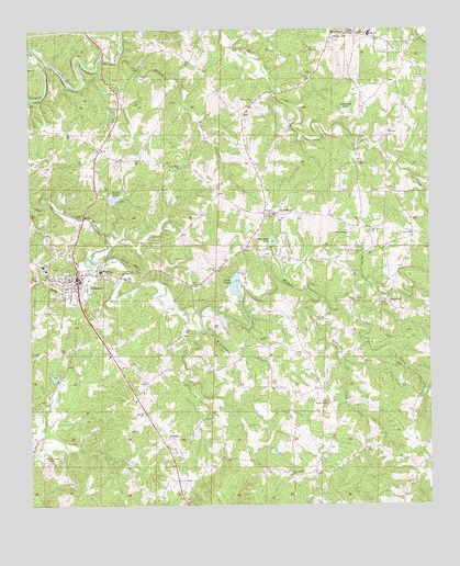
Wedowee, AL USGS Topographic Map
Click on map above to begin viewing in our Map Viewer.

This topographic map contains these locations and features:
Feature Name Type Latitude Longitude GNIS ID View Map
A and M Volunteer Fire DepartmentBuildingN33.3318°W85.4760°2683140View Map
AvaPopulated PlaceN33.3432°W85.4780°113301View Map
Ava ChurchChurchN33.3454°W85.4783°140187View Map
Barton LakeReservoirN33.3306°W85.4733°113532View Map
Bear Creek CemeteryCemeteryN33.3726°W85.4038°1805729View Map
Bear Creek United Methodist ChurchChurchN33.3729°W85.4036°113673View Map
Boone CreekStreamN33.3037°W85.3963°114737View Map
Burke ChapelChurchN33.2768°W85.4069°164032View Map
Burns Lake Number 2ReservoirN33.3051°W85.4400°131420View Map
Burns LakesReservoirN33.3099°W85.4356°115256View Map
Burns Number 2 DamDamN33.3051°W85.4400°131419View Map
Calvary ChurchChurchN33.2640°W85.4547°115415View Map
Carpenter DamDamN33.3134°W85.4516°131425View Map
Carpenter LakeReservoirN33.3134°W85.4516°131424View Map
CorbinPopulated PlaceN33.3015°W85.4255°140206View Map
CurtPopulated PlaceN33.3737°W85.4305°140211View Map
Friendship ChurchChurchN33.2585°W85.4183°118692View Map
Frog Level BranchStreamN33.3137°W85.4794°118726View Map
Green ChapelChurchN33.2940°W85.4258°164063View Map
Green CreekStreamN33.2954°W85.4477°119338View Map
HaywoodPopulated PlaceN33.3037°W85.3886°156463View Map
Henson BranchStreamN33.3671°W85.4722°119982View Map
HobsonPopulated PlaceN33.2807°W85.4075°140225View Map
Liberty GrovePopulated PlaceN33.3534°W85.4294°140231View Map
Liberty Grove CemeteryCemeteryN33.3571°W85.4283°1805671View Map
Liberty Grove Congregational Methodist ChurchChurchN33.3568°W85.4297°121565View Map
McBurnett Ford (historical)CrossingN33.3501°W85.3886°140233View Map
McCain DamDamN33.3318°W85.4783°131447View Map
McManus DamDamN33.2635°W85.4250°131363View Map
McManus PondReservoirN33.2641°W85.4243°131364View Map
MidwayPopulated PlaceN33.2743°W85.4627°140238View Map
Midway CemeteryCemeteryN33.2743°W85.4647°1730346View Map
Midway United Methodist ChurchChurchN33.2740°W85.4644°122713View Map
Mount PleasantPopulated PlaceN33.3126°W85.3930°140241View Map
Mud CreekStreamN33.3707°W85.4986°123551View Map
New HopePopulated PlaceN33.3265°W85.4225°123781View Map
New Hope DamDamN33.3184°W85.4233°131430View Map
New Hope LakeReservoirN33.3195°W85.4239°123847View Map
New Hope Volunteer Fire DepartmentBuildingN33.3271°W85.4234°2683139View Map
New Life ChurchChurchN33.2787°W85.4650°164179View Map
Noonday ChurchChurchN33.3265°W85.4258°123968View Map
Oak Grove Church of ChristChurchN33.3223°W85.3936°124092View Map
Old Rocky Branch CemeteryCemeteryN33.3173°W85.3977°124239View Map
PeacePopulated PlaceN33.3271°W85.4280°140249View Map
Randolph CountyCivilN33.2938°W85.4591°161582View Map
Randolph County High SchoolSchoolN33.3112°W85.4777°135804View Map
Randolph County Sheriff's OfficeBuildingN33.3093°W85.4843°2751842View Map
Rocky BranchPopulated PlaceN33.3240°W85.3952°135817View Map
Rocky BranchStreamN33.3084°W85.3950°125801View Map
Rocky Branch Baptist ChurchChurchN33.3215°W85.4002°125839View Map
Rollins CreekStreamN33.3059°W85.4150°125915View Map
Strain DamDamN33.3534°W85.4016°131466View Map
TennantPopulated PlaceN33.2682°W85.4569°157148View Map
Town of WedoweeCivilN33.3077°W85.4864°2406851View Map
Traylor Family CemeteryCemeteryN33.3668°W85.4364°2723775View Map
Victory ChurchChurchN33.2871°W85.4686°135826View Map
WedoweePopulated PlaceN33.3090°W85.4847°153913View Map
Wedowee Club LakeReservoirN33.2838°W85.4926°131384View Map
Wedowee Club Lake DamDamN33.2834°W85.4916°131385View Map
Wedowee High SchoolSchoolN33.3129°W85.4958°135829View Map
Wedowee Hospital and ClinicHospitalN33.3113°W85.4856°2669272View Map
Wedowee Police DepartmentBuildingN33.3101°W85.4845°2752020View Map
Wedowee Post OfficePost OfficeN33.3215°W85.4863°167868View Map
Wedowee Volunteer Fire DepartmentBuildingN33.3096°W85.4855°2683188View Map
WestPopulated PlaceN33.2571°W85.4166°135831View Map
Wildcat Creek CemeteryCemeteryN33.2618°W85.4941°128967View Map
Willingham BranchStreamN33.2959°W85.4455°129042View Map
WoodlandPopulated PlaceN33.3743°W85.3997°129193View Map
Woodland High SchoolSchoolN33.3737°W85.3930°135833View Map
Woodland LakeReservoirN33.3538°W85.4007°129197View Map
Woodland Post OfficePost OfficeN33.3745°W85.3994°167860View Map
Woodland Volunteer Fire DepartmentBuildingN33.3734°W85.3956°2682737View Map
Zion ChurchChurchN33.3634°W85.4116°129341View Map
Zion Rest ChurchChurchN33.3393°W85.4527°129358View Map

Note: Coordinates in the location and feature list above are referenced to NAD83 datum.


Copyright (C) 2008-2024 Ryan Niemi / Sunset Dynamics ... All Rights Reserved