TopoQuest Logo
Do you find TopoQuest useful?
Help keep TopoQuest running and adding new maps/features by donating!
Bitcoin:  19c7KJd3qBynnjoSw5npx9KScwjBe4ifkT
Litecoin:  LXs6TkuXGGXo1vDsWCkWVdjQX94eUKd6ui
Home View Maps Find Maps Find Places Resources & Links


Oktaha, Oklahoma Topographic Map

USGS Map Title: Oktaha, OK
USGS Map MRC: 35095E4
DRG (GeoTIFF) Download: o35095e4.tif


Neighboring USGS Topographic Map Quads:


  Beland, OK  
35095F5
 

  Southwest Muskogee, OK  
35095F4
 

  Southeast Muskogee, OK  
35095F3
 

  Wainwright, OK  
35095E5
 

  Oktaha, OK  
35095E4
 

  Keefton, OK  
35095E3
 

  Checotah, OK  
35095D5
 

  Warner NW, OK  
35095D4
 

  Warner, OK  
35095D3


Map MRC Location:

N36°
W96°
N36°
W95°
H8 H7 H6 H5 H4 H3 H2 H1
G8 G7 G6 G5 G4 G3 G2 G1
F8 F7 F6 F5 F4 F3 F2 F1
E8 E7 E6 E5 E4 E3 E2 E1
D8 D7 D6 D5 D4 D3 D2 D1
C8 C7 C6 C5 C4 C3 C2 C1
B8 B7 B6 B5 B4 B3 B2 B1
A8 A7 A6 A5 A4 A3 A2 A1
N35°
W96°
N35°
W95°

Oktaha, OK USGS 1:24K Topographic Map Preview:
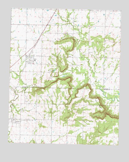
Oktaha, OK USGS Topographic Map
Click on map above to begin viewing in our Map Viewer.

This topographic map contains these locations and features:
Feature Name Type Latitude Longitude GNIS ID View Map
Anderson CreekStreamN35.5529°W95.4769°1089627View Map
Butler CreekStreamN35.5593°W95.4014°1090749View Map
Butler Creek CemeteryCemeteryN35.6019°W95.4311°2712537View Map
Butler Creek Indian Baptist ChurchChurchN35.6020°W95.4366°1090750View Map
Combs CemeteryCemeteryN35.5387°W95.4811°1091593View Map
Elk CreekStreamN35.5470°W95.4930°1092532View Map
Grayson CemeteryCemeteryN35.5809°W95.4327°1093351View Map
Honey SpringsSpringN35.5307°W95.4858°1093891View Map
Honey Springs BranchStreamN35.5359°W95.4961°1093892View Map
Honey Springs CemeteryCemeteryN35.5473°W95.4827°1093893View Map
Liberty ChurchChurchN35.6245°W95.4097°1094611View Map
May Evergreen ChurchChurchN35.5370°W95.4236°1095187View Map
Mount Zion ChurchChurchN35.5370°W95.3780°1095629View Map
Mount Zion ChurchChurchN35.6137°W95.4275°1095630View Map
Muskogee CountyCivilN35.6161°W95.3795°1101838View Map
New Hope CemeteryCemeteryN35.5934°W95.4136°1095806View Map
New Hope ChurchChurchN35.5857°W95.4103°1095820View Map
Oknoname 101006 DamDamN35.6134°W95.4002°1755356View Map
Oknoname 101006 ReservoirReservoirN35.6144°W95.4011°1755357View Map
Oknoname 101007 DamDamN35.5684°W95.4503°1755358View Map
Oknoname 101007 ReservoirReservoirN35.5684°W95.4503°1755359View Map
OktahaPopulated PlaceN35.5765°W95.4750°1096224View Map
Oktaha CemeteryCemeteryN35.5815°W95.4650°1096225View Map
Oktaha Community CemeteryCemeteryN35.6164°W95.4553°2712540View Map
Oktaha Elementary SchoolSchoolN35.5771°W95.4722°1803484View Map
Oktaha High SchoolSchoolN35.5771°W95.4722°1790422View Map
Oktaha Post OfficePost OfficeN35.5760°W95.4774°1818105View Map
Oktaha Volunteer Fire DepartmentBuildingN35.5760°W95.4787°2657382View Map
Rattlesnake MountainsRangeN35.5240°W95.3764°1097061View Map
Reinhardt LakeReservoirN35.5675°W95.4499°1097157View Map
RentiesvillePopulated PlaceN35.5215°W95.4950°1097165View Map
Rentiesville Area Rural Fire DepartmentBuildingN35.5215°W95.4854°2657234View Map
Timberly CreekStreamN35.5604°W95.4108°1098915View Map
Town of OktahaCivilN35.5776°W95.4778°2413077View Map
Town of RentiesvilleCivilN35.5331°W95.4849°2412543View Map
Township of BeckCivilN35.5223°W95.3808°1824636View Map
Township of DarlingCivilN35.5973°W95.4364°1824628View Map
Wayside CreekStreamN35.5470°W95.4930°1099449View Map

Note: Coordinates in the location and feature list above are referenced to NAD83 datum.


Copyright (C) 2008-2024 Ryan Niemi / Sunset Dynamics ... All Rights Reserved