TopoQuest Logo
Do you find TopoQuest useful?
Help keep TopoQuest running and adding new maps/features by donating!
Bitcoin:  19c7KJd3qBynnjoSw5npx9KScwjBe4ifkT
Litecoin:  LXs6TkuXGGXo1vDsWCkWVdjQX94eUKd6ui
Home View Maps Find Maps Find Places Resources & Links


Warner NW, Oklahoma Topographic Map

USGS Map Title: Warner NW, OK
USGS Map MRC: 35095D4
DRG (GeoTIFF) Download: o35095d4.tif


Neighboring USGS Topographic Map Quads:


  Wainwright, OK  
35095E5
 

  Oktaha, OK  
35095E4
 

  Keefton, OK  
35095E3
 

  Checotah, OK  
35095D5
 

  Warner NW, OK  
35095D4
 

  Warner, OK  
35095D3
 

  Eufaula, OK  
35095C5
 

  Texanna, OK  
35095C4
 

  Porum, OK  
35095C3


Map MRC Location:

N36°
W96°
N36°
W95°
H8 H7 H6 H5 H4 H3 H2 H1
G8 G7 G6 G5 G4 G3 G2 G1
F8 F7 F6 F5 F4 F3 F2 F1
E8 E7 E6 E5 E4 E3 E2 E1
D8 D7 D6 D5 D4 D3 D2 D1
C8 C7 C6 C5 C4 C3 C2 C1
B8 B7 B6 B5 B4 B3 B2 B1
A8 A7 A6 A5 A4 A3 A2 A1
N35°
W96°
N35°
W95°

Warner NW, OK USGS 1:24K Topographic Map Preview:
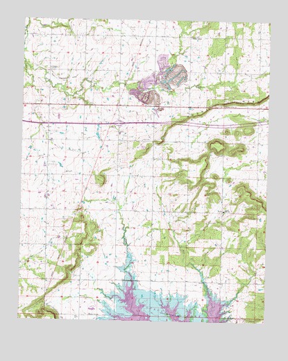
Warner NW, OK USGS Topographic Map
Click on map above to begin viewing in our Map Viewer.

This topographic map contains these locations and features:
Feature Name Type Latitude Longitude GNIS ID View Map
Central High SchoolSchoolN35.4209°W95.3969°1091165View Map
Central High Volunteer Fire DepartmentBuildingN35.4204°W95.4511°2657522View Map
Checotah DivisionCivilN35.4339°W95.4820°1937667View Map
Duchess Creek Wildlife Management AreaReserveN35.3882°W95.4244°1763685View Map
Duchess LandingCivilN35.3985°W95.4166°2631102View Map
Duchess LandingPopulated PlaceN35.3918°W95.4161°1853464View Map
Duchess Landing Census Designated PlaceCensusN35.3985°W95.4166°2408691View Map
McIntosh Non-CommunityCivilN35.4267°W95.3974°2631133View Map
McNaulty CemeteryCemeteryN35.4395°W95.4866°1095278View Map
Mount NeboSummitN35.4676°W95.3800°1095764View Map
Mount Nebo CemeteryCemeteryN35.4914°W95.3825°2746188View Map
Paradise CemeteryCemeteryN35.4801°W95.4864°1096423View Map
Prairie View SchoolSchoolN35.3776°W95.4641°1096916View Map
Shady GrovePopulated PlaceN35.4932°W95.4161°1100827View Map
Shady Grove CemeteryCemeteryN35.4928°W95.4167°2746189View Map
Shady Grove Census Designated PlaceCensusN35.4443°W95.4091°2408718View Map
Shady Grove Central High Volunteer Fire DepartmentBuildingN35.4646°W95.4115°2657082View Map
Shady Grove CommunityCivilN35.4443°W95.4091°2631172View Map
Shady Grove CreekStreamN35.4804°W95.4994°1097943View Map
Twin Grove CemeteryCemeteryN35.4289°W95.3908°2711815View Map
Vandier CemeteryCemeteryN35.4937°W95.4314°1099222View Map
West CemeteryCemeteryN35.4504°W95.4391°1099529View Map

Note: Coordinates in the location and feature list above are referenced to NAD83 datum.


Copyright (C) 2008-2025 Ryan Niemi / Sunset Dynamics ... All Rights Reserved