TopoQuest Logo
Do you find TopoQuest useful?
Help keep TopoQuest running and adding new maps/features by donating!
Bitcoin:  19c7KJd3qBynnjoSw5npx9KScwjBe4ifkT
Litecoin:  LXs6TkuXGGXo1vDsWCkWVdjQX94eUKd6ui
Home View Maps Find Maps Find Places Resources & Links


Checotah, Oklahoma Topographic Map

USGS Map Title: Checotah, OK
USGS Map MRC: 35095D5
DRG (GeoTIFF) Download: o35095d5.tif


Neighboring USGS Topographic Map Quads:


  Council Hill, OK  
35095E6
 

  Wainwright, OK  
35095E5
 

  Oktaha, OK  
35095E4
 

  Pierce, OK  
35095D6
 

  Checotah, OK  
35095D5
 

  Warner NW, OK  
35095D4
 

  Stidham, OK  
35095C6
 

  Eufaula, OK  
35095C5
 

  Texanna, OK  
35095C4


Map MRC Location:

N36°
W96°
N36°
W95°
H8 H7 H6 H5 H4 H3 H2 H1
G8 G7 G6 G5 G4 G3 G2 G1
F8 F7 F6 F5 F4 F3 F2 F1
E8 E7 E6 E5 E4 E3 E2 E1
D8 D7 D6 D5 D4 D3 D2 D1
C8 C7 C6 C5 C4 C3 C2 C1
B8 B7 B6 B5 B4 B3 B2 B1
A8 A7 A6 A5 A4 A3 A2 A1
N35°
W96°
N35°
W95°

Checotah, OK USGS 1:24K Topographic Map Preview:
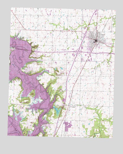
Checotah, OK USGS Topographic Map
Click on map above to begin viewing in our Map Viewer.

This topographic map contains these locations and features:
Feature Name Type Latitude Longitude GNIS ID View Map
Bessie C Tabor Cemetery (historical)CemeteryN35.4418°W95.6169°1847454View Map
ChecotahPopulated PlaceN35.4701°W95.5230°1091227View Map
Checotah City Lake EastReservoirN35.4418°W95.5628°1752368View Map
Checotah City Lake East DamDamN35.4418°W95.5636°1752367View Map
Checotah City Lake WestReservoirN35.4410°W95.5702°1754866View Map
Checotah City Lake West DamDamN35.4401°W95.5703°1754865View Map
Checotah Emergency Ambulance ServiceBuildingN35.4699°W95.5246°2695951View Map
Checotah High SchoolSchoolN35.4681°W95.5245°1803890View Map
Checotah Intermediate Elementary SchoolSchoolN35.4609°W95.5274°2713074View Map
Checotah IOOF Home CemeteryCemeteryN35.4808°W95.5153°2746380View Map
Checotah Middle SchoolSchoolN35.4681°W95.5257°1803889View Map
Checotah Police DepartmentBuildingN35.4691°W95.5226°2757457View Map
Checotah Volunteer Fire DepartmentBuildingN35.4699°W95.5246°2656993View Map
Church of ChristChurchN35.4690°W95.5200°1782649View Map
City of ChecotahCivilN35.4820°W95.5224°2409438View Map
Deep Fork ChurchChurchN35.4190°W95.5653°1091997View Map
First Baptist ChurchChurchN35.4693°W95.5255°1782650View Map
First Free Will Baptist ChurchChurchN35.4748°W95.5219°1782651View Map
Fountainhead Lodge AirparkAirportN35.3869°W95.6007°1102467View Map
Fountainhead State ParkParkN35.4048°W95.6067°1747198View Map
Green Lawn CemeteryCemeteryN35.4512°W95.5394°1093378View Map
Indian Territory Checotah CemeteryCemeteryN35.4694°W95.5319°2711813View Map
Longfellow Independent SchoolSchoolN35.4693°W95.5253°1803891View Map
Lotawatah Volunteer Fire DepartmentBuildingN35.4415°W95.5995°2657087View Map
Marshall Elementary SchoolSchoolN35.4604°W95.5295°1803892View Map
Nellie CreekStreamN35.3920°W95.5158°1095786View Map
North Canadian RiverStreamN35.3751°W95.6100°1101886View Map
Oknoname 121004 DamDamN35.4534°W95.5369°1755541View Map
Oknoname 121004 ReservoirReservoirN35.4556°W95.5347°1755542View Map
Oknoname 121005 DamDamN35.4518°W95.5336°1755543View Map
Oknoname 121005 ReservoirReservoirN35.4518°W95.5336°1755544View Map
OnapaPopulated PlaceN35.4059°W95.5533°1096271View Map
Onapa Fire Department Station 1 HeadquartersBuildingN35.4081°W95.5524°2657280View Map
Onapa Fire Department Station 2BuildingN35.3857°W95.5782°2657235View Map
Onapa LakeReservoirN35.4009°W95.5671°1096272View Map
Onapa Lake DamDamN35.4034°W95.5703°1757667View Map
Richard CemeteryCemeteryN35.4397°W95.6036°1097190View Map
Township of ChecotahCivilN35.4779°W95.5058°1824635View Map
Warner LakeReservoirN35.4034°W95.5703°1757670View Map
Warner Lake DamDamN35.4034°W95.5703°1757669View Map

Note: Coordinates in the location and feature list above are referenced to NAD83 datum.


Copyright (C) 2008-2025 Ryan Niemi / Sunset Dynamics ... All Rights Reserved