TopoQuest Logo
Do you find TopoQuest useful?
Help keep TopoQuest running and adding new maps/features by donating!
Bitcoin:  19c7KJd3qBynnjoSw5npx9KScwjBe4ifkT
Litecoin:  LXs6TkuXGGXo1vDsWCkWVdjQX94eUKd6ui
Home View Maps Find Maps Find Places Resources & Links


Olivesburg, Ohio Topographic Map

USGS Map Title: Olivesburg, OH
USGS Map MRC: 40082H4
DRG (GeoTIFF) Download: o40082h4.tif


Neighboring USGS Topographic Map Quads:


  Greenwich, OH  
41082A5
 

  New London, OH  
41082A4
 

  Nova, OH  
41082A3
 

  Shiloh, OH  
40082H5
 

  Olivesburg, OH  
40082H4
 

  Ashland North, OH  
40082H3
 

  Mansfield North, OH  
40082G5
 

  Pavonia, OH  
40082G4
 

  Ashland South, OH  
40082G3


Map MRC Location:

N41°
W83°
N41°
W82°
H8 H7 H6 H5 H4 H3 H2 H1
G8 G7 G6 G5 G4 G3 G2 G1
F8 F7 F6 F5 F4 F3 F2 F1
E8 E7 E6 E5 E4 E3 E2 E1
D8 D7 D6 D5 D4 D3 D2 D1
C8 C7 C6 C5 C4 C3 C2 C1
B8 B7 B6 B5 B4 B3 B2 B1
A8 A7 A6 A5 A4 A3 A2 A1
N40°
W83°
N40°
W82°

Olivesburg, OH USGS 1:24K Topographic Map Preview:
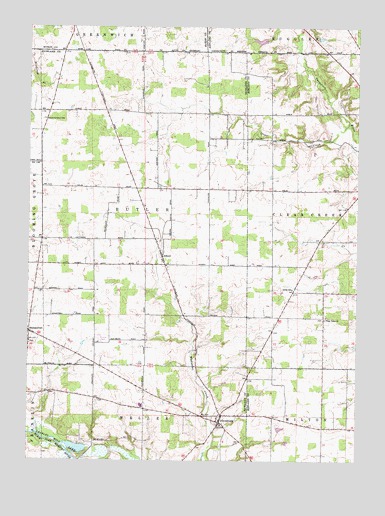
Olivesburg, OH USGS Topographic Map
Click on map above to begin viewing in our Map Viewer.

This topographic map contains these locations and features:
Feature Name Type Latitude Longitude GNIS ID View Map
AdarioPopulated PlaceN40.9345°W82.4502°1064298View Map
Adario CemeteryCemeteryN40.9306°W82.4468°1955055View Map
Adario Post Office (historical)Post OfficeN40.9348°W82.4499°2056215View Map
Amish SchoolSchoolN40.9242°W82.4166°1037407View Map
Blooming Grove CemeteryCemeteryN40.9734°W82.4941°1038124View Map
Blooming Grove Church (historical)ChurchN40.9737°W82.4935°1049796View Map
Brubaker CreekStreamN40.8773°W82.4846°1066604View Map
Brytes ChurchyardCemeteryN40.9158°W82.3871°1806336View Map
Butler Church (historical)ChurchN40.9753°W82.4371°1049798View Map
Clear CreekStreamN40.9728°W82.4149°1039161View Map
Clear Creek ChurchChurchN40.9159°W82.4074°1039167View Map
Crestview High SchoolSchoolN40.8909°W82.4568°1049797View Map
Fowler Woods State Nature PreserveParkN40.9712°W82.4735°1955096View Map
Marks LakeReservoirN40.9961°W82.4120°1077779View Map
Marks Lake DamDamN40.9967°W82.4099°1077778View Map
Mount Olivet CemeteryCemeteryN40.8839°W82.4282°1955070View Map
Noble Road LandfillLocaleN40.9689°W82.4828°2635457View Map
OlivesburgPopulated PlaceN40.8859°W82.4288°1065203View Map
Olivesburg Post Office (historical)Post OfficeN40.8862°W82.4291°2043330View Map
Oswalt Aerodrome Airport (historical)AirportN40.9190°W82.4804°1082254View Map
Pin Oak Mobile Home ParkPopulated PlaceN40.9103°W82.4731°2516713View Map
Reformed Church CemeteryCemeteryN40.9159°W82.3877°1806366View Map
ShenandoahPopulated PlaceN40.9117°W82.4993°1049174View Map
Shenandoah Christian ChurchChurchN40.9092°W82.4993°1063264View Map
Shenandoah Post Office (historical)Post OfficeN40.9112°W82.4985°2056236View Map
Township of ButlerCivilN40.9477°W82.4561°1086873View Map
Township of Clear CreekCivilN40.9475°W82.3785°1085703View Map
White DairyLocaleN40.9375°W82.3800°2706059View Map

Note: Coordinates in the location and feature list above are referenced to NAD83 datum.


Copyright (C) 2008-2025 Ryan Niemi / Sunset Dynamics ... All Rights Reserved