TopoQuest Logo
Do you find TopoQuest useful?
Help keep TopoQuest running and adding new maps/features by donating!
Bitcoin:  19c7KJd3qBynnjoSw5npx9KScwjBe4ifkT
Litecoin:  LXs6TkuXGGXo1vDsWCkWVdjQX94eUKd6ui
Home View Maps Find Maps Find Places Resources & Links


Olympia, Kentucky Topographic Map

USGS Map Title: Olympia, KY
USGS Map MRC: 38083A6
DRG (GeoTIFF) Download: o38083a6.tif


Neighboring USGS Topographic Map Quads:


  Owingsville, KY  
38083B7
 

  Colfax, KY  
38083B6
 

  Farmers, KY  
38083B5
 

  Preston, KY  
38083A7
 

  Olympia, KY  
38083A6
 

  Salt Lick, KY  
38083A5
 

  Means, KY  
37083H7
 

  Frenchburg, KY  
37083H6
 

  Scranton, KY  
37083H5


Map MRC Location:

N39°
W84°
N39°
W83°
H8 H7 H6 H5 H4 H3 H2 H1
G8 G7 G6 G5 G4 G3 G2 G1
F8 F7 F6 F5 F4 F3 F2 F1
E8 E7 E6 E5 E4 E3 E2 E1
D8 D7 D6 D5 D4 D3 D2 D1
C8 C7 C6 C5 C4 C3 C2 C1
B8 B7 B6 B5 B4 B3 B2 B1
A8 A7 A6 A5 A4 A3 A2 A1
N38°
W84°
N38°
W83°

Olympia, KY USGS 1:24K Topographic Map Preview:
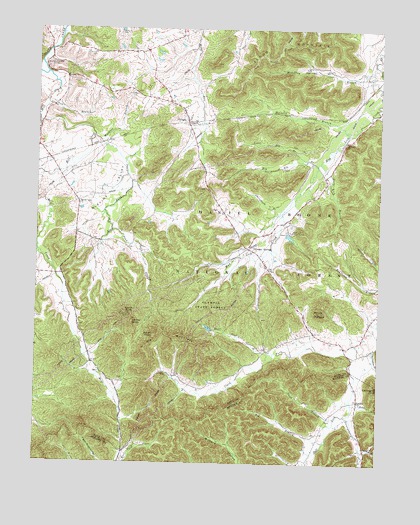
Olympia, KY USGS Topographic Map
Click on map above to begin viewing in our Map Viewer.

This topographic map contains these locations and features:
Feature Name Type Latitude Longitude GNIS ID View Map
Big BranchStreamN38.0065°W83.6446°510622View Map
Big Elk BranchStreamN38.0859°W83.6480°510651View Map
Big MountainSummitN38.0373°W83.6971°510681View Map
Black Sulpher Spring (historical)Populated PlaceN38.0591°W83.6704°2416385View Map
Blevins School (historical)SchoolN38.0747°W83.7344°2416386View Map
Blevins ValleyValleyN38.0927°W83.7264°510788View Map
Blevins Valley ChurchChurchN38.0742°W83.7346°510789View Map
Blockhouse Iron MineMineN38.1066°W83.7236°2416387View Map
Blue Bank CreekStreamN38.0940°W83.7294°510797View Map
Botts BranchStreamN38.0176°W83.6344°510861View Map
Bourbon FurnaceLocaleN38.1142°W83.7474°510863View Map
Carrington BranchStreamN38.0326°W83.6271°511231View Map
Carrington RockSummitN38.0220°W83.6252°511232View Map
Center KnobSummitN38.0406°W83.7146°511303View Map
Chalybeate BranchStreamN38.0717°W83.6616°511309View Map
Clark ForkStreamN38.0309°W83.6335°511375View Map
Deer Lick BranchStreamN38.0320°W83.6630°511773View Map
Elys BranchStreamN38.0984°W83.7491°512064View Map
Gooden BranchStreamN38.0612°W83.7491°512342View Map
Howard Hill MineMineN38.1090°W83.7168°2416414View Map
Jackson CemeteryCemeteryN38.1240°W83.7205°512966View Map
Jackson SchoolhouseSchoolN38.1179°W83.7221°2416416View Map
Jackson Schoolhouse (historical)Populated PlaceN38.1179°W83.7221°2416417View Map
Johnson BranchStreamN38.0051°W83.6307°513043View Map
Little Elk BranchStreamN38.0873°W83.6519°513479View Map
Little Slate Creek (historical)Populated PlaceN38.0180°W83.7418°2416431View Map
McCarty BranchStreamN38.0959°W83.6380°513847View Map
McGulley BranchStreamN38.1148°W83.6271°513865View Map
Mill CreekStreamN38.1123°W83.7466°513987View Map
Mill Creek (historical)Populated PlaceN38.0225°W83.7233°2416439View Map
Mill Creek ChurchChurchN38.0125°W83.7181°2416440View Map
Mill Creek School (historical)SchoolN38.0233°W83.7200°2416441View Map
Mormon ChurchChurchN38.1108°W83.7394°2416444View Map
Mount OlympusSummitN38.0437°W83.6471°514354View Map
Mud Lick ChurchChurchN38.0929°W83.6374°514136View Map
Mud Lick CreekStreamN38.1129°W83.6282°516711View Map
Mud Lick Youth CampLocaleN38.0667°W83.6571°514139View Map
Nichols BranchStreamN38.0203°W83.6908°507361View Map
North KnobSummitN38.0431°W83.7160°514295View Map
Old Fields CemeteryCemeteryN38.1067°W83.7155°514320View Map
OlympiaPopulated PlaceN38.0981°W83.6957°514351View Map
Olympia Christian ChurchChurchN38.1005°W83.6868°2416456View Map
Olympia Lookout TowerTowerN38.0429°W83.7161°2416457View Map
Olympia Post OfficePost OfficeN38.0982°W83.6957°2416458View Map
Olympia Railroad Station (historical)LocaleN38.0975°W83.6949°2416459View Map
Olympia School (historical)SchoolN38.1018°W83.6977°2416460View Map
Olympia SpringsPopulated PlaceN38.0620°W83.6730°514352View Map
Olympia Springs Volunteer Fire DepartmentBuildingN38.0629°W83.6729°2637266View Map
Olympia State ForestForestN38.0442°W83.6896°514353View Map
Olympian Springs Church of GodChurchN38.0587°W83.6673°2416461View Map
Olympian Springs Post Office (historical)Post OfficeN38.0616°W83.6699°2416462View Map
Olympian Springs School (historical)SchoolN38.0659°W83.6672°2416463View Map
Pine Grove (historical)Populated PlaceN38.0321°W83.6660°2416473View Map
Pine Grove School (historical)SchoolN38.0316°W83.6666°2515322View Map
Polk BranchStreamN38.1023°W83.7466°514677View Map
Pond Lick BranchStreamN38.0673°W83.7221°514694View Map
Preston School (historical)SchoolN38.1095°W83.7372°2416485View Map
Pugh BranchStreamN38.0131°W83.6405°514791View Map
Richardson BranchStreamN38.0245°W83.6992°507360View Map
Rockhouse BranchStreamN38.0245°W83.6992°507366View Map
Salt Lick School (historical)SchoolN38.0008°W83.6508°2400806View Map
Shrout CemeteryCemeteryN38.1179°W83.7296°515395View Map
Slate BlockhouseLocaleN38.1143°W83.7469°2416504View Map
Slate Creek Iron Works Post Office (historical)Post OfficeN38.1139°W83.7466°2416505View Map
Slate Lick BranchStreamN38.0867°W83.6469°515474View Map
South KnobSummitN38.0370°W83.7069°515554View Map
Stonequarry CreekStreamN38.0140°W83.6369°515732View Map
Suddith (historical)Populated PlaceN38.0294°W83.6295°2416511View Map
SudithPopulated PlaceN38.0184°W83.6321°515774View Map
Sudith Post Office (historical)Post OfficeN38.0051°W83.6301°2400813View Map
Terrell CemeteryCemeteryN38.0124°W83.6322°2400816View Map
Upper Salt Lick (historical)Populated PlaceN38.0406°W83.6286°2416516View Map
Upper Salt Lick School (historical)SchoolN38.0412°W83.6282°2416517View Map
W R Belcher Airport (historical)AirportN38.0567°W83.7088°517455View Map
Washers BranchStreamN38.0926°W83.7269°516236View Map

Note: Coordinates in the location and feature list above are referenced to NAD83 datum.


Copyright (C) 2008-2024 Ryan Niemi / Sunset Dynamics ... All Rights Reserved