TopoQuest Logo
Do you find TopoQuest useful?
Help keep TopoQuest running and adding new maps/features by donating!
Bitcoin:  19c7KJd3qBynnjoSw5npx9KScwjBe4ifkT
Litecoin:  LXs6TkuXGGXo1vDsWCkWVdjQX94eUKd6ui
Home View Maps Find Maps Find Places Resources & Links


Salt Lick, Kentucky Topographic Map

USGS Map Title: Salt Lick, KY
USGS Map MRC: 38083A5
DRG (GeoTIFF) Download: o38083a5.tif


Neighboring USGS Topographic Map Quads:


  Colfax, KY  
38083B6
 

  Farmers, KY  
38083B5
 

  Morehead, KY  
38083B4
 

  Olympia, KY  
38083A6
 

  Salt Lick, KY  
38083A5
 

  Bangor, KY  
38083A4
 

  Frenchburg, KY  
37083H6
 

  Scranton, KY  
37083H5
 

  Ezel, KY  
37083H4


Map MRC Location:

N39°
W84°
N39°
W83°
H8 H7 H6 H5 H4 H3 H2 H1
G8 G7 G6 G5 G4 G3 G2 G1
F8 F7 F6 F5 F4 F3 F2 F1
E8 E7 E6 E5 E4 E3 E2 E1
D8 D7 D6 D5 D4 D3 D2 D1
C8 C7 C6 C5 C4 C3 C2 C1
B8 B7 B6 B5 B4 B3 B2 B1
A8 A7 A6 A5 A4 A3 A2 A1
N38°
W84°
N38°
W83°

Salt Lick, KY USGS 1:24K Topographic Map Preview:
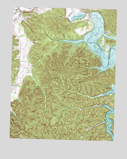
Salt Lick, KY USGS Topographic Map
Click on map above to begin viewing in our Map Viewer.

This topographic map contains these locations and features:
Feature Name Type Latitude Longitude GNIS ID View Map
Alfrey CemeteryCemeteryN38.1029°W83.5074°510241View Map
Alum KnobSummitN38.0887°W83.5451°2416372View Map
Big Cave RunStreamN38.0695°W83.5260°510636View Map
Billy BranchStreamN38.1006°W83.5007°510727View Map
Billy Branch Picnic AreaLocaleN38.1040°W83.5130°516705View Map
Boardinghouse BranchStreamN38.0476°W83.5588°510819View Map
Boat Gunnel Branch Picnic AreaLocaleN38.1012°W83.5032°516704View Map
Buck Branch TrailTrailN38.0537°W83.5810°510997View Map
Buck Creek HillSummitN38.0546°W83.5729°2416646View Map
Buck Creek TrailTrailN38.0423°W83.5324°516707View Map
Buckskin TrailTrailN38.0776°W83.5277°516779View Map
Campbell HollowValleyN38.1143°W83.6116°511169View Map
Caney CreekStreamN38.0942°W83.5652°511200View Map
Cape BranchStreamN38.0109°W83.5285°511212View Map
Carey BranchStreamN38.1190°W83.5363°511215View Map
Carey CemeteryCemeteryN38.1234°W83.5402°511216View Map
Carrington Rock TrailTrailN38.0451°W83.5957°511233View Map
Cassity Cemetery OneCemeteryN38.1233°W83.5387°2079684View Map
Cave Run Post Office (historical)Post OfficeN38.0710°W83.5150°2416390View Map
Cave Run TrailTrailN38.0756°W83.5444°511278View Map
Cedar CliffsCliffN38.0656°W83.5755°511291View Map
Cedar Cliffs TrailTrailN38.0656°W83.5805°489171View Map
Chestnut CliffsCliffN38.0390°W83.5474°511327View Map
City of Salt LickCivilN38.1194°W83.6156°2405408View Map
Clark State Fish HatcheryLocaleN38.1170°W83.5457°517111View Map
Clear CreekStreamN38.0687°W83.6119°511392View Map
Clear Creek FurnacePopulated PlaceN38.0501°W83.5891°511397View Map
Clear Creek Furnace Picnic AreaLocaleN38.0495°W83.5888°516708View Map
Clear Creek LakeReservoirN38.0565°W83.5968°516709View Map
Costigan Post Office (historical)Post OfficeN38.0675°W83.6016°2416394View Map
Cross Over TrailTrailN38.0690°W83.5546°511653View Map
Daniel Boone National Forest Cumberland Ranger District Morehead OfficeBuildingN38.1233°W83.5260°2637445View Map
Dark Cave HollowValleyN38.0277°W83.5592°511717View Map
Dickerson CemeteryCemeteryN38.1140°W83.6091°511806View Map
Dickerson HollowValleyN38.1129°W83.6117°511807View Map
Fern Bluff Parking AreaLocaleN38.1231°W83.5246°516699View Map
Fletchum HollowValleyN38.0424°W83.5323°512206View Map
Gate Post HillSummitN38.0079°W83.5809°512287View Map
Glady BranchStreamN38.0309°W83.5560°512326View Map
Glady HollowValleyN38.0191°W83.5886°512328View Map
Graveyard BranchStreamN38.0917°W83.5405°512405View Map
Green BranchStreamN38.1195°W83.5610°512429View Map
Grubbs HollowValleyN38.0417°W83.5296°512475View Map
Hickory HollowValleyN38.0948°W83.5621°512684View Map
Hicks HollowValleyN38.0762°W83.6064°512691View Map
High Bank Picnic AreaLocaleN38.1234°W83.5285°516700View Map
Hog HollowValleyN38.1134°W83.5384°512729View Map
Hog Pen TrailTrailN38.0776°W83.5385°512731View Map
Joes BranchStreamN38.0301°W83.5396°513025View Map
Knob HollowValleyN38.0444°W83.5422°513162View Map
Leatherwood (historical)Populated PlaceN38.0298°W83.5011°2400788View Map
Leatherwood Boat RampLocaleN38.0340°W83.5155°516706View Map
Leatherwood CreekStreamN38.0284°W83.5030°513282View Map
Leatherwood HillSummitN38.0439°W83.5742°2416638View Map
Leatherwood School (historical)SchoolN38.0298°W83.5011°2416639View Map
Lewis Chapel (historical)ChurchN38.1128°W83.5345°2416426View Map
Licking Post Office (historical)Post OfficeN38.1237°W83.6061°2416428View Map
Little Cave RunStreamN38.0640°W83.5205°513463View Map
Lower Salt Lick (historical)Populated PlaceN38.0992°W83.6209°2416432View Map
Lower Salt Lick School (historical)SchoolN38.0941°W83.6173°2416433View Map
Martin Cemetery OneCemeteryN38.1149°W83.5504°2079871View Map
Martins BranchStreamN38.0923°W83.6060°513810View Map
McDale BranchStreamN38.0431°W83.6185°513854View Map
McIntosh BranchStreamN38.0515°W83.5055°513867View Map
Merry BranchStreamN38.0620°W83.6144°513910View Map
Murder BranchStreamN38.0115°W83.5027°514164View Map
New Alfrey CemeteryCemeteryN38.1031°W83.5086°2079928View Map
Old Caney Iron Furnance (historical)LocaleN38.0933°W83.5678°2416451View Map
Pendleton BranchStreamN38.0512°W83.6169°514481View Map
Pergram BranchStreamN38.0356°W83.5827°514490View Map
Peter Cave RunStreamN38.0687°W83.5310°514510View Map
Pioneer Weapons Hunting AreaParkN38.0606°W83.5480°514620View Map
Ragland Railroad Station (historical)LocaleN38.0710°W83.5160°2416487View Map
Reynolds HollowStreamN38.0848°W83.5365°2416489View Map
Reynolds HollowValleyN38.0865°W83.5349°514899View Map
Salt LickPopulated PlaceN38.1201°W83.6146°515190View Map
Salt Lick CreekStreamN38.1242°W83.6063°515191View Map
Salt Lick DivisionCivilN38.0844°W83.6198°1937238View Map
Salt Lick Fire DepartmentBuildingN38.1194°W83.6158°2636488View Map
Salt Lick Post OfficePost OfficeN38.1191°W83.6153°2416493View Map
Salt Lick Railroad Station (historical)LocaleN38.1178°W83.6171°2416494View Map
Scott CreekStreamN38.1079°W83.5157°515299View Map
Scott Creek Boat RampLocaleN38.1023°W83.5132°517329View Map
Scott Creek MarinaLocaleN38.1037°W83.5110°516703View Map
Scott Creek Recreation SiteLocaleN38.1006°W83.5085°516701View Map
Shallow Flats Wildlife TrailTrailN38.1001°W83.5044°516806View Map
Sheltowee TraceTrailN38.0941°W83.5721°2416500View Map
Skidmore CreekStreamN38.0209°W83.5060°515452View Map
Stone Quarry BranchStreamN38.0537°W83.5938°515726View Map
Sulphur BranchStreamN38.0942°W83.5655°515806View Map
Tailwater Picnic Area and Boat LaunchLocaleN38.1170°W83.5388°516697View Map
Tater KnobSummitN38.0551°W83.5424°515874View Map
Tram Road HollowValleyN38.0459°W83.5460°516016View Map
Trough Lick BranchStreamN38.0862°W83.5496°516026View Map
Twin KnobsSummitN38.0945°W83.5060°516080View Map
Twin Knobs Recreation SiteLocaleN38.0948°W83.5169°516702View Map
Upper Salt Lick Christian ChurchChurchN38.0501°W83.6185°505899View Map
White Sulpher (historical)Populated PlaceN38.0689°W83.5973°2416524View Map
White Sulpher School (historical)SchoolN38.0689°W83.5973°2416525View Map
White Sulphur BranchStreamN38.0642°W83.6032°516330View Map
Wickliffe Forge Post Office (historical)Post OfficeN38.0941°W83.5638°2416526View Map
Wolfpen HollowValleyN38.0554°W83.5936°516464View Map
Yale Post Office (historical)Post OfficeN38.0528°W83.5008°2416529View Map
Young Post Office (historical)Post OfficeN38.0669°W83.6019°2416547View Map
Young SpringsSpringN38.0724°W83.5904°2416530View Map
Young Springs Post Office (historical)Post OfficeN38.0727°W83.5900°2416531View Map

Note: Coordinates in the location and feature list above are referenced to NAD83 datum.


Copyright (C) 2008-2024 Ryan Niemi / Sunset Dynamics ... All Rights Reserved