TopoQuest Logo
Do you find TopoQuest useful?
Help keep TopoQuest running and adding new maps/features by donating!
Bitcoin:  19c7KJd3qBynnjoSw5npx9KScwjBe4ifkT
Litecoin:  LXs6TkuXGGXo1vDsWCkWVdjQX94eUKd6ui
Home View Maps Find Maps Find Places Resources & Links


Chic, Tennessee Topographic Map

USGS Map Title: Chic, TN
USGS Map MRC: 35089H6
DRG (GeoTIFF) Download: o35089h6.tif


Neighboring USGS Topographic Map Quads:


  Steele, MO  
36089A7
 

  Cottonwood Point, MO  
36089A6
 

  Caruthersville SE, TN  
36089A5
 

  Armorel, AR  
35089H7
 

  Chic, TN  
35089H6
 

  Knob Creek, TN  
35089H5
 

  Rosa, AR  
35089G7
 

  Open Lake, TN  
35089G6
 

  Ripley North, TN  
35089G5


Map MRC Location:

N36°
W90°
N36°
W89°
H8 H7 H6 H5 H4 H3 H2 H1
G8 G7 G6 G5 G4 G3 G2 G1
F8 F7 F6 F5 F4 F3 F2 F1
E8 E7 E6 E5 E4 E3 E2 E1
D8 D7 D6 D5 D4 D3 D2 D1
C8 C7 C6 C5 C4 C3 C2 C1
B8 B7 B6 B5 B4 B3 B2 B1
A8 A7 A6 A5 A4 A3 A2 A1
N35°
W90°
N35°
W89°

Chic, TN USGS 1:24K Topographic Map Preview:
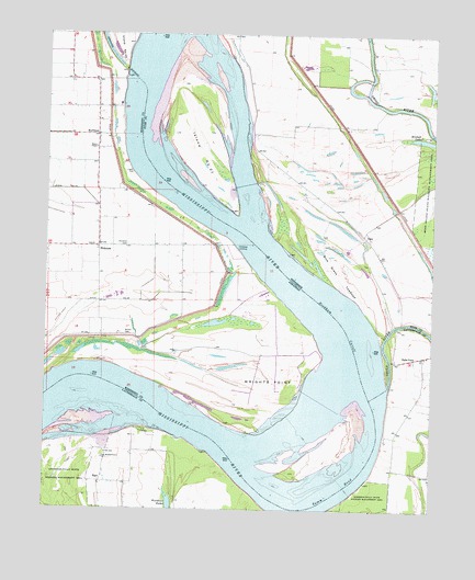
Chic, TN USGS Topographic Map
Click on map above to begin viewing in our Map Viewer.

This topographic map contains these locations and features:
Feature Name Type Latitude Longitude GNIS ID View Map
Barfield BarBarN35.8770°W89.6579°1311082View Map
BarrPopulated PlaceN35.8823°W89.7312°1314629View Map
Barr LandingLocaleN35.8959°W89.7126°1318066View Map
Barr School (historical)SchoolN35.8845°W89.7315°1318067View Map
Below Tamm Bend DikesLeveeN35.8973°W89.7245°1311084View Map
Blue Grass TowheadFlatN35.9362°W89.6556°1277758View Map
Buckner CemeteryCemeteryN35.9445°W89.7237°76454View Map
Cheek LandingLocaleN35.9392°W89.6840°59442View Map
ChicPopulated PlaceN35.9465°W89.6467°1314837View Map
Chick School (historical)SchoolN35.9620°W89.6706°1309783View Map
Church of God (historical)ChurchN35.9812°W89.7420°59401View Map
District 11 (historical)CivilN35.9598°W89.6501°1310264View Map
Ditch Number 38CanalN35.9298°W89.7326°82239View Map
Hales PointPopulated PlaceN35.9101°W89.6270°1315174View Map
Hales Point ChurchChurchN35.9156°W89.6265°1318096View Map
Hales Point LandingLocaleN35.9098°W89.6398°1309806View Map
HickmanPopulated PlaceN35.9442°W89.7331°50043View Map
Hickman Chapel (historical)ChurchN35.9445°W89.7120°59441View Map
Hickman LandingPopulated PlaceN35.9429°W89.6873°81378View Map
Hickman RevetmentLeveeN35.9637°W89.7223°59446View Map
HuffmanPopulated PlaceN35.9734°W89.7340°57066View Map
Huffman LandingLocaleN35.9809°W89.7259°59447View Map
Hughes LandingLocaleN35.9609°W89.7184°59445View Map
Island Number Twenty-oneIslandN35.9684°W89.7004°1289093View Map
Island Number Twentyone ChuteChannelN35.9765°W89.6879°1309818View Map
Island Number Twentyone Chute DikeLeveeN35.9606°W89.6856°1309819View Map
Marys Chapel Baptist ChurchChurchN35.9704°W89.7342°82816View Map
Michell (historical)Populated PlaceN35.9542°W89.6362°1310336View Map
Midway LandingLocaleN35.9701°W89.6934°1309826View Map
Mitchell LakeLakeN35.9727°W89.6289°1294114View Map
Mouth of River Styx LandingLocaleN35.9126°W89.7270°59437View Map
Nebraska LandingLocaleN35.8898°W89.6967°1318119View Map
Needham CutoffBendN35.9240°W89.6559°77797View Map
New Mitchell Grove ChurchChurchN35.8884°W89.7306°1295608View Map
Obion RiverStreamN35.9076°W89.6390°1296225View Map
Saint Luke Church (historical)ChurchN35.9445°W89.7148°59440View Map
Saint Marys ChurchChurchN35.9445°W89.7348°59438View Map
School Number 48 (historical)SchoolN35.9445°W89.7329°59439View Map
Tamm BendBendN35.8801°W89.6551°55422View Map
Tamm LandingLocaleN35.8770°W89.6545°1318135View Map
Township of CanadianCivilN35.9185°W89.7466°69653View Map
Township of Hickman (historical)CivilN35.9501°W89.7376°69662View Map
Walker CemeteryCemeteryN35.9206°W89.7242°55956View Map
Wrights PointCapeN35.9109°W89.6859°56562View Map
Wrights Point Dikes (historical)LeveeN35.9262°W89.6687°59443View Map
Wrights Point LandingLocaleN35.9181°W89.6617°59444View Map

Note: Coordinates in the location and feature list above are referenced to NAD83 datum.


Copyright (C) 2008-2025 Ryan Niemi / Sunset Dynamics ... All Rights Reserved