TopoQuest Logo
Do you find TopoQuest useful?
Help keep TopoQuest running and adding new maps/features by donating!
Bitcoin:  19c7KJd3qBynnjoSw5npx9KScwjBe4ifkT
Litecoin:  LXs6TkuXGGXo1vDsWCkWVdjQX94eUKd6ui
Home View Maps Find Maps Find Places Resources & Links


South River, North Carolina Topographic Map

USGS Map Title: South River, NC
USGS Map MRC: 34076H5
DRG (GeoTIFF) Download: o34076h5.tif


Neighboring USGS Topographic Map Quads:


  Oriental, NC  
35076A6
 

  Broad Creek, NC  
35076A5
 

  Point of Marsh, NC  
35076A4
 

  Merrimon, NC  
34076H6
 

  South River, NC  
34076H5
 

  Long Bay, NC  
34076H4
 

  Core Creek, NC  
34076G6
 

  Williston, NC  
34076G5
 

  Davis, NC  
34076G4


Map MRC Location:

N35°
W77°
N35°
W76°
H8 H7 H6 H5 H4 H3 H2 H1
G8 G7 G6 G5 G4 G3 G2 G1
F8 F7 F6 F5 F4 F3 F2 F1
E8 E7 E6 E5 E4 E3 E2 E1
D8 D7 D6 D5 D4 D3 D2 D1
C8 C7 C6 C5 C4 C3 C2 C1
B8 B7 B6 B5 B4 B3 B2 B1
A8 A7 A6 A5 A4 A3 A2 A1
N34°
W77°
N34°
W76°

South River, NC USGS 1:24K Topographic Map Preview:
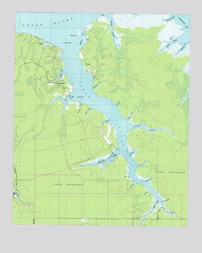
South River, NC USGS Topographic Map
Click on map above to begin viewing in our Map Viewer.

This topographic map contains these locations and features:
Feature Name Type Latitude Longitude GNIS ID View Map
Abraham BayBayN34.9993°W76.5105°980024View Map
Big CreekStreamN34.9529°W76.5810°981377View Map
Broad CreekStreamN34.9849°W76.5066°981930View Map
Brown CreekStreamN34.9988°W76.5588°982009View Map
Buck CreekStreamN34.9102°W76.5360°982101View Map
Cedar PointCapeN34.9499°W76.5794°982889View Map
Coffee CreekStreamN34.9466°W76.5516°983337View Map
Dixon CreekStreamN34.9446°W76.5685°984225View Map
Doe CreekStreamN34.9174°W76.5416°984252View Map
Duck CreekStreamN34.9041°W76.5405°984377View Map
East Fork South RiverStreamN34.8910°W76.5208°984506View Map
Eastman CreekStreamN34.9332°W76.5421°984560View Map
Elisha CreekStreamN34.9013°W76.5283°984682View Map
Hardy CreekStreamN34.9660°W76.5888°986398View Map
Herring PondReservoirN34.9809°W76.6043°986659View Map
Horton BayBayN34.9849°W76.5763°987149View Map
Horton PointCapeN34.9874°W76.5799°987155View Map
Little CreekStreamN34.9374°W76.5430°988583View Map
LukensPopulated PlaceN34.9707°W76.5741°1021306View Map
Miry GutGutN34.8943°W76.5283°990076View Map
Mulberry CreekStreamN34.9546°W76.5680°990776View Map
Neal CreekGutN34.8999°W76.5383°990882View Map
Old House CreekStreamN34.9474°W76.5769°991571View Map
Parsons CreekStreamN34.9835°W76.5041°991899View Map
Pitman CreekBayN34.9854°W76.5127°992423View Map
Rich Island GutGutN34.8904°W76.5169°993291View Map
Royal CreekStreamN34.9368°W76.5569°993785View Map
South RiverStreamN34.9877°W76.5908°995204View Map
South RiverPopulated PlaceN34.9588°W76.5969°1022714View Map
South River - Merrimon Fire DepartmentBuildingN34.9603°W76.6000°2638999View Map
South River LightTowerN34.9824°W76.5849°995208View Map
South River Merrimon Rescue SquadBuildingN34.9602°W76.5999°2720396View Map
Southwest CreekStreamN34.9193°W76.5480°995254View Map
Sportsmans VillagePopulated PlaceN34.9729°W76.5922°1002754View Map
Township of MerrimonCivilN34.9608°W76.5830°1026505View Map
West Fork South RiverStreamN34.8910°W76.5208°997019View Map

Note: Coordinates in the location and feature list above are referenced to NAD83 datum.


Copyright (C) 2008-2024 Ryan Niemi / Sunset Dynamics ... All Rights Reserved