TopoQuest Logo
Do you find TopoQuest useful?
Help keep TopoQuest running and adding new maps/features by donating!
Bitcoin:  19c7KJd3qBynnjoSw5npx9KScwjBe4ifkT
Litecoin:  LXs6TkuXGGXo1vDsWCkWVdjQX94eUKd6ui
Home View Maps Find Maps Find Places Resources & Links


Orland, Maine Topographic Map

USGS Map Title: Orland, ME
USGS Map MRC: 44068E6
DRG (GeoTIFF) Download: o44068e6.tif


Neighboring USGS Topographic Map Quads:


  Hampden, ME  
44068F7
 

  Brewer Lake, ME  
44068F6
 

  Green Lake, ME  
44068F5
 

  Bucksport, ME  
44068E7
 

  Orland, ME  
44068E6
 

  Branch Lake, ME  
44068E5
 

  Castine, ME  
44068D7
 

  Penobscot, ME  
44068D6
 

  Blue Hill, ME  
44068D5


Map MRC Location:

N45°
W69°
N45°
W68°
H8 H7 H6 H5 H4 H3 H2 H1
G8 G7 G6 G5 G4 G3 G2 G1
F8 F7 F6 F5 F4 F3 F2 F1
E8 E7 E6 E5 E4 E3 E2 E1
D8 D7 D6 D5 D4 D3 D2 D1
C8 C7 C6 C5 C4 C3 C2 C1
B8 B7 B6 B5 B4 B3 B2 B1
A8 A7 A6 A5 A4 A3 A2 A1
N44°
W69°
N44°
W68°

Orland, ME USGS 1:24K Topographic Map Preview:
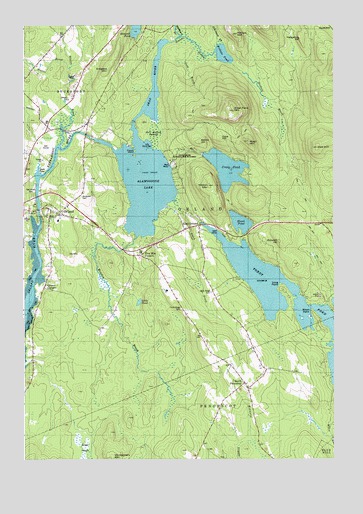
Orland, ME USGS Topographic Map
Click on map above to begin viewing in our Map Viewer.

This topographic map contains these locations and features:
Feature Name Type Latitude Longitude GNIS ID View Map
Alamoosook DamDamN44.5921°W68.7214°1773773View Map
Alamoosook LakeReservoirN44.5795°W68.7011°561114View Map
Annear Copper MineMineN44.5109°W68.6331°561267View Map
Atkins HillSummitN44.5914°W68.6791°561334View Map
Atkinson BrookStreamN44.6192°W68.6703°561337View Map
Back Ridge CemeteryCemeteryN44.5483°W68.6742°561411View Map
Balsam Cove CampgroundLocaleN44.5534°W68.6642°1911363View Map
Blaisdell HillSummitN44.5628°W68.6470°562543View Map
Bucksport Golf ClubLocaleN44.5904°W68.7411°1911448View Map
Cave HillSummitN44.5928°W68.6706°563706View Map
Condon HillSummitN44.6247°W68.6525°564284View Map
Craig Brook National Fish HatcheryParkN44.5873°W68.6860°580746View Map
Craig PondReservoirN44.5836°W68.6681°564448View Map
Craig Pond BrookStreamN44.5842°W68.6914°579958View Map
Craig Pond DamDamN44.5879°W68.6778°1773775View Map
Cranes CornersPopulated PlaceN44.5492°W68.7414°564497View Map
Dead RiverStreamN44.5912°W68.7036°564880View Map
Dressers MountainSummitN44.6123°W68.7159°565285View Map
Duck CoveBayN44.5834°W68.7436°565331View Map
East OrlandPopulated PlaceN44.5667°W68.6798°565647View Map
East Orland Post OfficePost OfficeN44.5665°W68.6848°1911554View Map
Evergreen CemeteryCemeteryN44.5754°W68.7267°565968View Map
Five Mile CornersPopulated PlaceN44.5590°W68.7025°579308View Map
French IslandIslandN44.5873°W68.7059°566569View Map
Front Ridge CemeteryCemeteryN44.5428°W68.6864°566609View Map
Gold BrookStreamN44.6170°W68.6800°566869View Map
Great HeathSwampN44.5015°W68.7253°567151View Map
Great Pond MountainSummitN44.6005°W68.6653°567177View Map
Gulch BrookStreamN44.5734°W68.6925°567370View Map
Heart PondLakeN44.5681°W68.6625°567869View Map
Hedgehog HillSummitN44.6212°W68.6384°567891View Map
Hell Bottom SwampSwampN44.5931°W68.6967°567912View Map
Hillside CemeteryCemeteryN44.5215°W68.6611°2736656View Map
Hothole BrookStreamN44.6195°W68.6920°568340View Map
Hothole BrookStreamN44.6140°W68.6681°579978View Map
Hothole MountainSummitN44.6225°W68.6640°568341View Map
Hothole PondLakeN44.6165°W68.6692°568342View Map
Little PondLakeN44.5452°W68.7034°569976View Map
Long PointCapeN44.5490°W68.6467°570262View Map
Loon IslandIslandN44.5829°W68.7034°570363View Map
Main Stem Orland River ReservoirReservoirN44.5700°W68.7432°1773782View Map
Mason MountainSummitN44.5789°W68.6751°570876View Map
Mead MountainSummitN44.5915°W68.6597°571038View Map
Meadow BrookStreamN44.5637°W68.7048°571051View Map
Montgomery MountainSummitN44.5009°W68.7142°571522View Map
Moosehorn StreamStreamN44.6209°W68.6870°571643View Map
Mountain BrookStreamN44.5973°W68.6973°571793View Map
Narramissic RiverStreamN44.5795°W68.7439°572044View Map
North PenobscotPopulated PlaceN44.5217°W68.6614°572379View Map
Oak Grove CemeteryCemeteryN44.5759°W68.7461°572565View Map
Oak HillSummitN44.5897°W68.6316°580801View Map
OrlandPopulated PlaceN44.5704°W68.7359°572769View Map
Orland Consolidated School (historical)SchoolN44.5687°W68.7356°1911835View Map
Orland Fire StationBuildingN44.5728°W68.7320°2552691View Map
Orland Post OfficePost OfficeN44.5714°W68.7479°1911837View Map
Orland Village DamDamN44.5700°W68.7432°1773781View Map
Page Eldridge CemeteryCemeteryN44.5837°W68.7491°2740607View Map
Patton HillSummitN44.5026°W68.6860°573075View Map
Shady Oaks CampgroundLocaleN44.5704°W68.7481°1911936View Map
Short PointCapeN44.5420°W68.6345°575438View Map
Stubbs BrookStreamN44.6123°W68.7317°576458View Map
The Sand BarBarN44.5895°W68.7006°576916View Map
Toddy Pond DamDamN44.5680°W68.6781°1773777View Map
Town of OrlandCivilN44.5731°W68.6777°582650View Map
Whispering Pines CampgroundLocaleN44.5640°W68.6673°1912084View Map
Whites BrookStreamN44.5898°W68.7356°578389View Map

Note: Coordinates in the location and feature list above are referenced to NAD83 datum.


Copyright (C) 2008-2024 Ryan Niemi / Sunset Dynamics ... All Rights Reserved