TopoQuest Logo
Do you find TopoQuest useful?
Help keep TopoQuest running and adding new maps/features by donating!
Bitcoin:  19c7KJd3qBynnjoSw5npx9KScwjBe4ifkT
Litecoin:  LXs6TkuXGGXo1vDsWCkWVdjQX94eUKd6ui
Home View Maps Find Maps Find Places Resources & Links


Penobscot, Maine Topographic Map

USGS Map Title: Penobscot, ME
USGS Map MRC: 44068D6
DRG (GeoTIFF) Download: o44068d6.tif


Neighboring USGS Topographic Map Quads:


  Bucksport, ME  
44068E7
 

  Orland, ME  
44068E6
 

  Branch Lake, ME  
44068E5
 

  Castine, ME  
44068D7
 

  Penobscot, ME  
44068D6
 

  Blue Hill, ME  
44068D5
 

  Cape Rosier, ME  
44068C7
 

  Sargentville, ME  
44068C6
 

  Brooklin, ME  
44068C5


Map MRC Location:

N45°
W69°
N45°
W68°
H8 H7 H6 H5 H4 H3 H2 H1
G8 G7 G6 G5 G4 G3 G2 G1
F8 F7 F6 F5 F4 F3 F2 F1
E8 E7 E6 E5 E4 E3 E2 E1
D8 D7 D6 D5 D4 D3 D2 D1
C8 C7 C6 C5 C4 C3 C2 C1
B8 B7 B6 B5 B4 B3 B2 B1
A8 A7 A6 A5 A4 A3 A2 A1
N44°
W69°
N44°
W68°

Penobscot, ME USGS 1:24K Topographic Map Preview:
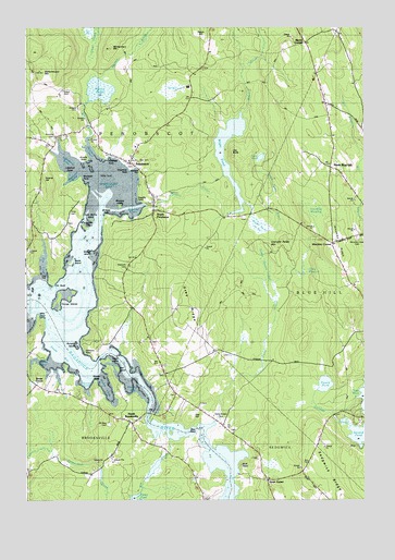
Penobscot, ME USGS Topographic Map
Click on map above to begin viewing in our Map Viewer.

This topographic map contains these locations and features:
Feature Name Type Latitude Longitude GNIS ID View Map
Aunt Mollie IslandIslandN44.4490°W68.7259°580718View Map
Bagaduce FallsFallsN44.3954°W68.7056°1911357View Map
Bagaduce RiverBayN44.4177°W68.7401°561431View Map
Battle IslandIslandN44.4379°W68.7334°561731View Map
Bay CemeteryCemeteryN44.4648°W68.7084°561742View Map
Bear HeadSummitN44.3906°W68.6914°561833View Map
Bluff HeadSummitN44.3844°W68.6702°562616View Map
Bridges CemeteryCemeteryN44.4787°W68.7311°562954View Map
Bridges PointCapeN44.4501°W68.7203°580719View Map
Brooksville Volunteer Fire Department Station 2BuildingN44.3954°W68.7115°2552810View Map
Camp StreamStreamN44.3959°W68.6795°563415View Map
Camp Stream BogSwampN44.4367°W68.6614°563416View Map
Camp Stream CemeteryCemeteryN44.3967°W68.6775°563417View Map
Carpenter PointCapeN44.4656°W68.7117°580717View Map
Chandler Parker MountainSummitN44.4432°W68.6532°563832View Map
Fourth PondLakeN44.4057°W68.6393°566490View Map
Freethy PointCapeN44.4545°W68.7067°580716View Map
Gravel IslandIslandN44.4404°W68.7256°567091View Map
Gray CemeteryCemeteryN44.4135°W68.6767°2736642View Map
Gray Number 1 CemeteryCemeteryN44.4170°W68.7035°2736644View Map
Gray RidgeRidgeN44.4256°W68.6911°567106View Map
Grays CornerPopulated PlaceN44.3804°W68.6597°579358View Map
Great MeadowSwampN44.4359°W68.6472°580714View Map
Green CoveBayN44.4084°W68.7231°567203View Map
Green IslandIslandN44.4120°W68.7203°567221View Map
Grindle PointCapeN44.4656°W68.7275°567336View Map
Hawes PointCapeN44.4059°W68.7239°567774View Map
Hinckley CornerLocaleN44.4429°W68.6370°581378View Map
Hinckley MeadowSwampN44.4526°W68.6428°580696View Map
Hinckley RidgeRidgeN44.4417°W68.6336°581379View Map
Hutchins CemeteryCemeteryN44.4715°W68.7392°568528View Map
Hutchins CoveBayN44.4676°W68.7261°568529View Map
Hutchins PointCapeN44.4667°W68.7217°581380View Map
Johnson PointCapeN44.4148°W68.7256°568934View Map
Leach CemeteryCemeteryN44.4831°W68.7364°569415View Map
Littlefield CoveBayN44.4654°W68.7359°570117View Map
Littlefield PointCapeN44.4612°W68.7353°580722View Map
Marks CornerPopulated PlaceN44.4959°W68.6450°579499View Map
McCaslin StreamStreamN44.4776°W68.6695°570951View Map
Mill BrookStreamN44.4709°W68.7259°580712View Map
Mills PointCapeN44.4229°W68.7453°571401View Map
Mount Rest CemeteryCemeteryN44.3948°W68.7192°571784View Map
Mountain View CemeteryCemeteryN44.4442°W68.6275°580695View Map
North Blue HillLocaleN44.4631°W68.6356°572255View Map
North BrooksvillePopulated PlaceN44.3954°W68.7106°572312View Map
Northern BayBayN44.4590°W68.7208°572456View Map
Oak HillPopulated PlaceN44.3962°W68.6886°579582View Map
PenobscotPopulated PlaceN44.4645°W68.7111°573172View Map
Penobscot ChurchChurchN44.4087°W68.6984°573176View Map
Penobscot Elementary SchoolSchoolN44.4685°W68.7092°1911856View Map
Penobscot Post OfficePost OfficeN44.4654°W68.7101°2789366View Map
Penobscot United Methodist ChurchChurchN44.4656°W68.7098°1911858View Map
Penobscot Volunteer Fire Department Main StationBuildingN44.4670°W68.7101°2552705View Map
Penobscot Volunteer Fire Department StorageBuildingN44.4509°W68.7031°2553112View Map
Perkins HillSummitN44.4577°W68.7431°573204View Map
Perry CemeteryCemeteryN44.4501°W68.7331°573215View Map
Pierce PondLakeN44.4834°W68.7222°573315View Map
Pumpkin IslandIslandN44.4162°W68.7309°573888View Map
Second PondLakeN44.3926°W68.6258°575207View Map
Seneca BrookStreamN44.4854°W68.7195°575234View Map
South BayBayN44.4142°W68.7375°575751View Map
South PenobscotPopulated PlaceN44.4509°W68.7025°575881View Map
South Penobscot CemeteryCemeteryN44.4542°W68.7011°1911963View Map
Sparks IslandIslandN44.4470°W68.7281°575969View Map
Stover CornerPopulated PlaceN44.4054°W68.7461°579745View Map
Stover CoveBayN44.4056°W68.7286°576418View Map
Tapley CoveBayN44.4106°W68.7434°576653View Map
The BluffsCliffN44.4673°W68.6745°576764View Map
Tills CoveBayN44.4370°W68.7436°577105View Map
Tills PointCapeN44.4329°W68.7398°577106View Map
Town of PenobscotCivilN44.4748°W68.7083°582668View Map
Turtle PondLakeN44.4657°W68.6628°577455View Map
Turtle Pond BrookStreamN44.4540°W68.6692°580713View Map
Wallamatogus MountainSummitN44.4890°W68.7438°577810View Map
Wardwell CoveBayN44.4606°W68.7323°580702View Map
Wardwell PointCapeN44.4581°W68.7289°577837View Map
Westcott CemeteryCemeteryN44.4367°W68.7125°578241View Map
Wight HeathSwampN44.4470°W68.6597°578456View Map
Wight PondLakeN44.4514°W68.6713°578457View Map
Winslow CoveBayN44.4526°W68.7106°580715View Map
Winslow IslandIslandN44.4526°W68.7150°578596View Map
Winslow StreamStreamN44.4526°W68.7053°578600View Map
Youngs IslandsIslandN44.4281°W68.7378°578802View Map

Note: Coordinates in the location and feature list above are referenced to NAD83 datum.


Copyright (C) 2008-2025 Ryan Niemi / Sunset Dynamics ... All Rights Reserved