TopoQuest Logo
Do you find TopoQuest useful?
Help keep TopoQuest running and adding new maps/features by donating!
Bitcoin:  19c7KJd3qBynnjoSw5npx9KScwjBe4ifkT
Litecoin:  LXs6TkuXGGXo1vDsWCkWVdjQX94eUKd6ui
Home View Maps Find Maps Find Places Resources & Links


Bucksport, Maine Topographic Map

USGS Map Title: Bucksport, ME
USGS Map MRC: 44068E7
DRG (GeoTIFF) Download: o44068e7.tif


Neighboring USGS Topographic Map Quads:


  Snow Mountain, ME  
44068F8
 

  Hampden, ME  
44068F7
 

  Brewer Lake, ME  
44068F6
 

  Mount Waldo, ME  
44068E8
 

  Bucksport, ME  
44068E7
 

  Orland, ME  
44068E6
 

  Searsport, ME  
44068D8
 

  Castine, ME  
44068D7
 

  Penobscot, ME  
44068D6


Map MRC Location:

N45°
W69°
N45°
W68°
H8 H7 H6 H5 H4 H3 H2 H1
G8 G7 G6 G5 G4 G3 G2 G1
F8 F7 F6 F5 F4 F3 F2 F1
E8 E7 E6 E5 E4 E3 E2 E1
D8 D7 D6 D5 D4 D3 D2 D1
C8 C7 C6 C5 C4 C3 C2 C1
B8 B7 B6 B5 B4 B3 B2 B1
A8 A7 A6 A5 A4 A3 A2 A1
N44°
W69°
N44°
W68°

Bucksport, ME USGS 1:24K Topographic Map Preview:
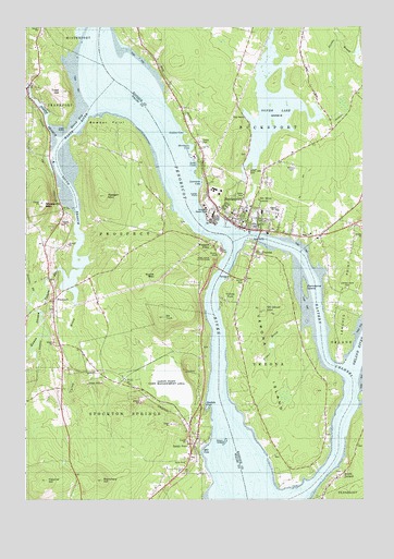
Bucksport, ME USGS Topographic Map
Click on map above to begin viewing in our Map Viewer.

This topographic map contains these locations and features:
Feature Name Type Latitude Longitude GNIS ID View Map
Blanchard HillSummitN44.5052°W68.8467°562562View Map
Bowden PointCapeN44.6012°W68.8445°562789View Map
Buck CemeteryCemeteryN44.5711°W68.7846°1911441View Map
Buck CemeteryCemeteryN44.5751°W68.7973°1911442View Map
Buck Memorial LibraryBuildingN44.5716°W68.7920°1911445View Map
BucksportPopulated PlaceN44.5737°W68.7956°563131View Map
Bucksport Census Designated PlaceCensusN44.6006°W68.7944°2377895View Map
Bucksport High SchoolSchoolN44.5765°W68.7821°1911449View Map
Bucksport Historical Society MuseumBuildingN44.5715°W68.7959°1911450View Map
Bucksport Middle SchoolSchoolN44.5815°W68.7758°2738133View Map
Bucksport Police DepartmentBuildingN44.5741°W68.7948°2735917View Map
Bucksport Post OfficePost OfficeN44.5726°W68.7963°1911451View Map
Bucksport Public Safety Fire StationBuildingN44.5741°W68.7951°2552839View Map
Carley BrookStreamN44.5584°W68.8578°563550View Map
Collins CoveBayN44.5973°W68.8153°564234View Map
Colson StreamStreamN44.5584°W68.8581°564250View Map
Eastern ChannelChannelN44.5351°W68.7592°565715View Map
Eastern Maine Conference Seminary (historical)SchoolN44.5759°W68.7934°1911562View Map
Elm Street Congregational ChurchChurchN44.5734°W68.7931°1911587View Map
ErskingSummitN44.5344°W68.8148°565933View Map
Eustis MountainSummitN44.5598°W68.8256°580711View Map
Evangel Baptist AcademySchoolN44.5727°W68.7932°2737962View Map
Evangelical Baptist ChurchChurchN44.5729°W68.7934°1911592View Map
Fletcher HillSummitN44.5052°W68.8672°566300View Map
Fort Knox State Historic SiteParkN44.5640°W68.8059°579968View Map
Frankfort Post OfficePost OfficeN44.6075°W68.8735°2768988View Map
Frankfort Volunteer Village Fire StationBuildingN44.6089°W68.8737°2553190View Map
G Herbert Jewett Elementary SchoolSchoolN44.5760°W68.7874°1911625View Map
Gondola CoveBayN44.5259°W68.8086°566877View Map
Gross PointCapeN44.5387°W68.7592°581446View Map
Harriman CoveBayN44.5940°W68.8139°567671View Map
Hawes StreamStreamN44.5551°W68.8717°567775View Map
Heagan MountainSummitN44.5804°W68.8457°567853View Map
Lawrence CoveBayN44.5840°W68.8092°569407View Map
Leaches Point CemeteryCemeteryN44.5561°W68.7557°580741View Map
Luce CoveBayN44.5895°W68.8123°570568View Map
Maplewood CemeteryCemeteryN44.5559°W68.7559°569418View Map
Marks CemeteryCemeteryN44.5142°W68.7522°2736672View Map
Marsh BayBayN44.6023°W68.8525°570799View Map
Marsh River DamDamN44.6091°W68.8732°1773783View Map
Marsh StreamStreamN44.6090°W68.8731°570819View Map
Marsh Stream ReservoirReservoirN44.6090°W68.8731°1774558View Map
McCloud MountainSummitN44.5500°W68.7867°570954View Map
Miles Lane Elementary SchoolSchoolN44.5795°W68.7806°2738134View Map
Mill CoveBayN44.5126°W68.8103°571322View Map
Mosquito MountainSummitN44.5775°W68.8683°571735View Map
Mount OliveSummitN44.5795°W68.7881°572740View Map
Mount TuckSummitN44.5483°W68.8237°577380View Map
North Branch Marsh RiverStreamN44.5959°W68.8620°572278View Map
Northeast Historic Film LibraryBuildingN44.5723°W68.7954°2738362View Map
Odom LedgeBarN44.5154°W68.8009°580742View Map
Orland RiverStreamN44.5331°W68.7545°572770View Map
Penobscot Narrows BridgeBridgeN44.5589°W68.8031°2508320View Map
Penobscot Narrows ObservatoryTowerN44.5606°W68.8038°2508487View Map
Perkins BrookStreamN44.5548°W68.8717°573201View Map
Porcupina IslandIslandN44.5565°W68.7717°579996View Map
ProspectPopulated PlaceN44.5531°W68.8648°573833View Map
Prospect FerryPopulated PlaceN44.5670°W68.8053°573834View Map
Prospect Volunteer Fire StationBuildingN44.5530°W68.8647°2552690View Map
Reach High SchoolSchoolN44.5744°W68.7982°2737961View Map
Sandy PointPopulated PlaceN44.5148°W68.8128°574886View Map
Sandy Point Game Management AreaParkN44.5320°W68.8217°580703View Map
Sandy Point Post OfficePost OfficeN44.5199°W68.8109°2768961View Map
Silver LakeReservoirN44.6042°W68.7833°575464View Map
Silver Lake CemeteryCemeteryN44.5873°W68.7917°575465View Map
Silver Lake DamDamN44.5873°W68.7899°1773779View Map
South Branch Marsh RiverStreamN44.5979°W68.8561°575785View Map
South OrlandPopulated PlaceN44.5067°W68.7589°575875View Map
Stowers MeadowReservoirN44.5303°W68.8196°1774562View Map
Stowers Meadow DamDamN44.5226°W68.8138°1774561View Map
Stowers MeadowsSwampN44.5309°W68.8225°576425View Map
The Flying Dutchman CampgroundLocaleN44.5659°W68.7873°1912007View Map
Town of ProspectCivilN44.5609°W68.8676°582688View Map
Town of Verona IslandCivilN44.5338°W68.7822°582780View Map
Treat PointCapeN44.5970°W68.8609°577296View Map
Ulmer BrookStreamN44.5470°W68.7728°577524View Map
VeronaPopulated PlaceN44.5654°W68.7903°577711View Map
Verona BridgeBridgeN44.5696°W68.7885°1912051View Map
Verona IslandIslandN44.5381°W68.7878°577712View Map
Verona ParkPopulated PlaceN44.5526°W68.8011°577713View Map
Village CemeteryCemeteryN44.5585°W68.7931°1912053View Map
Waldo Peirce Reading Room and LibraryBuildingN44.6083°W68.8746°2738505View Map
Waldo-Hancock BridgeBridgeN44.5604°W68.8015°2508488View Map
Walter H Gardner Middle SchoolSchoolN44.5759°W68.7934°1912056View Map
Whitman CemeteryCemeteryN44.5115°W68.7806°1912088View Map
Whitman CemeteryCemeteryN44.5176°W68.7639°1912089View Map
York CemeteryCemeteryN44.5077°W68.7580°2736347View Map

Note: Coordinates in the location and feature list above are referenced to NAD83 datum.


Copyright (C) 2008-2024 Ryan Niemi / Sunset Dynamics ... All Rights Reserved