TopoQuest Logo
Do you find TopoQuest useful?
Help keep TopoQuest running and adding new maps/features by donating!
Bitcoin:  19c7KJd3qBynnjoSw5npx9KScwjBe4ifkT
Litecoin:  LXs6TkuXGGXo1vDsWCkWVdjQX94eUKd6ui
Home View Maps Find Maps Find Places Resources & Links


Hampden, Maine Topographic Map

USGS Map Title: Hampden, ME
USGS Map MRC: 44068F7
DRG (GeoTIFF) Download: o44068f7.tif


Neighboring USGS Topographic Map Quads:


  Hermon, ME  
44068G8
 

  Bangor, ME  
44068G7
 

  Veazie, ME  
44068G6
 

  Snow Mountain, ME  
44068F8
 

  Hampden, ME  
44068F7
 

  Brewer Lake, ME  
44068F6
 

  Mount Waldo, ME  
44068E8
 

  Bucksport, ME  
44068E7
 

  Orland, ME  
44068E6


Map MRC Location:

N45°
W69°
N45°
W68°
H8 H7 H6 H5 H4 H3 H2 H1
G8 G7 G6 G5 G4 G3 G2 G1
F8 F7 F6 F5 F4 F3 F2 F1
E8 E7 E6 E5 E4 E3 E2 E1
D8 D7 D6 D5 D4 D3 D2 D1
C8 C7 C6 C5 C4 C3 C2 C1
B8 B7 B6 B5 B4 B3 B2 B1
A8 A7 A6 A5 A4 A3 A2 A1
N44°
W69°
N44°
W68°

Hampden, ME USGS 1:24K Topographic Map Preview:
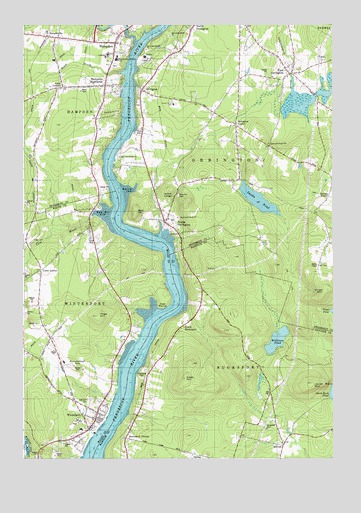
Hampden, ME USGS Topographic Map
Click on map above to begin viewing in our Map Viewer.

This topographic map contains these locations and features:
Feature Name Type Latitude Longitude GNIS ID View Map
AreyPopulated PlaceN44.7228°W68.8717°579103View Map
Areys CornersLocaleN44.7323°W68.8581°561289View Map
Bald HillSummitN44.6958°W68.8296°561505View Map
Bald Hill CoveBayN44.6951°W68.8442°561507View Map
Bald Hill ReachChannelN44.6887°W68.8281°580845View Map
Bartlett CoveBayN44.7017°W68.8317°561664View Map
Bucksport CenterPopulated PlaceN44.6312°W68.8339°579160View Map
Center Drive SchoolSchoolN44.7269°W68.8150°580841View Map
Cobb HillSummitN44.6481°W68.8100°564121View Map
Coles CornerCapeN44.6790°W68.8670°564220View Map
Cove BrookStreamN44.6812°W68.8742°564401View Map
Cove CemeteryCemeteryN44.6880°W68.8460°564402View Map
Creative PlaygroundParkN44.7395°W68.8381°1913438View Map
Dorothea Dix ParkParkN44.7251°W68.8386°580842View Map
Earl C McGraw SchoolSchoolN44.7409°W68.8414°1913469View Map
East OrringtonPopulated PlaceN44.7356°W68.7675°565648View Map
East Orrington Congregational ChurchChurchN44.7351°W68.7689°1913484View Map
East Orrington DamDamN44.7348°W68.7659°1774069View Map
Evergreen CemeteryCemeteryN44.6349°W68.7779°565970View Map
First Congregational ChurchChurchN44.7456°W68.8361°1913524View Map
George B Weatherbee SchoolSchoolN44.7411°W68.8405°1913545View Map
Goodale CemeteryCemeteryN44.7014°W68.7561°2736915View Map
Goodale CornerPopulated PlaceN44.7004°W68.7509°579339View Map
HampdenPopulated PlaceN44.7445°W68.8370°567550View Map
Hampden AcademySchoolN44.7423°W68.8444°1913566View Map
Hampden Census Designated PlaceCensusN44.7478°W68.8360°2377916View Map
Hampden Emergency Medical ServicesBuildingN44.7456°W68.8486°2666815View Map
Hampden Fire DepartmentBuildingN44.7464°W68.8474°2552830View Map
Hampden HighlandsPopulated PlaceN44.7323°W68.8411°567551View Map
Hampden Highlands United Methodist ChurchChurchN44.7327°W68.8459°1913570View Map
Hampden Police DepartmentBuildingN44.7463°W68.8474°2735855View Map
Hampden Post OfficePost OfficeN44.7457°W68.8486°1913572View Map
Hampden StationPopulated PlaceN44.7465°W68.8642°567552View Map
Jacob Buck MountainSummitN44.6467°W68.7587°568752View Map
Kings MountainSummitN44.6723°W68.7536°569211View Map
Leroy H Smith SchoolSchoolN44.6335°W68.8513°2738117View Map
Locust Grove CemeteryCemeteryN44.7383°W68.8387°2736923View Map
Lura E Hoit PoolLocaleN44.7453°W68.8436°1913676View Map
Mill CreekStreamN44.6965°W68.8203°580844View Map
MillvalePopulated PlaceN44.6287°W68.7700°571406View Map
North BucksportPopulated PlaceN44.6612°W68.8134°572315View Map
North OrringtonPopulated PlaceN44.7484°W68.8067°572370View Map
North WinterportPopulated PlaceN44.6776°W68.8486°580846View Map
Oak Hill CemeteryCemeteryN44.6417°W68.8481°572604View Map
Oak Hill CemeteryCemeteryN44.7111°W68.7790°2736933View Map
Oak PointCapeN44.6781°W68.8203°572626View Map
OrringtonPopulated PlaceN44.7312°W68.8264°572779View Map
Orrington CenterPopulated PlaceN44.7212°W68.7886°572780View Map
Orrington Fire Station and Rescue DepartmentBuildingN44.7356°W68.7673°2552887View Map
Orrington Police DepartmentBuildingN44.7270°W68.8043°2735854View Map
Orrington Post OfficePost OfficeN44.7279°W68.8270°1913366View Map
Orrington Public LibraryBuildingN44.7271°W68.8141°2738443View Map
Page HillSummitN44.6662°W68.8452°572919View Map
Pine Hill CemeteryCemeteryN44.7009°W68.8117°573377View Map
Punchbowl HillSummitN44.6511°W68.8533°573898View Map
Reeds BrookStreamN44.7365°W68.8339°574133View Map
Reeds Brook Middle SchoolSchoolN44.7388°W68.8428°1913839View Map
Riverview CemeteryCemeteryN44.6506°W68.8261°574267View Map
Saint Matthews Catholic ChurchChurchN44.7459°W68.8448°1913866View Map
Samuel L Wagner Middle SchoolSchoolN44.6359°W68.8596°2738018View Map
Smith LedgeBenchN44.7004°W68.8153°575628View Map
Snub PointCapeN44.7048°W68.8353°580843View Map
Souadabscook DamDamN44.7488°W68.8325°1774559View Map
Souadabscook StreamStreamN44.7453°W68.8292°575737View Map
Souadabscook Stream ReservoirReservoirN44.7488°W68.8325°1774560View Map
South OrringtonPopulated PlaceN44.6934°W68.8173°575876View Map
Swetts PondReservoirN44.6994°W68.7799°576616View Map
Town of OrringtonCivilN44.7150°W68.7790°582652View Map
Village CemeteryCemeteryN44.7271°W68.8284°1913962View Map
Weatherbee McGraw SchoolSchoolN44.7398°W68.8367°580840View Map
Williams PondLakeN44.6591°W68.7725°578520View Map
WinterportPopulated PlaceN44.6379°W68.8450°578607View Map
Winterport Census Designated PlaceCensusN44.6453°W68.8561°2377969View Map
Winterport Memorial LibraryBuildingN44.6348°W68.8477°2738414View Map
Winterport Post OfficePost OfficeN44.6310°W68.8535°2768922View Map
Winterport Volunteer Fire DepartmentBuildingN44.6351°W68.8464°2553093View Map
WKIT-FM (Brewer)TowerN44.6776°W68.7536°582288View Map

Note: Coordinates in the location and feature list above are referenced to NAD83 datum.


Copyright (C) 2008-2024 Ryan Niemi / Sunset Dynamics ... All Rights Reserved