TopoQuest Logo
Do you find TopoQuest useful?
Help keep TopoQuest running and adding new maps/features by donating!
Bitcoin:  19c7KJd3qBynnjoSw5npx9KScwjBe4ifkT
Litecoin:  LXs6TkuXGGXo1vDsWCkWVdjQX94eUKd6ui
Home View Maps Find Maps Find Places Resources & Links


Orrville, Alabama Topographic Map

USGS Map Title: Orrville, AL
USGS Map MRC: 32087C2
DRG (GeoTIFF) Download: o32087c2.tif


Neighboring USGS Topographic Map Quads:


  Browns, AL  
32087D3
 

  Marion Junction, AL  
32087D2
 

  Selma, AL  
32087D1
 

  Safford, AL  
32087C3
 

  Orrville, AL  
32087C2
 

  Blackwell Bend, AL  
32087C1
 

  Crumptonia, AL  
32087B3
 

  Tasso, AL  
32087B2
 

  Elm Bluff, AL  
32087B1


Map MRC Location:

N33°
W88°
N33°
W87°
H8 H7 H6 H5 H4 H3 H2 H1
G8 G7 G6 G5 G4 G3 G2 G1
F8 F7 F6 F5 F4 F3 F2 F1
E8 E7 E6 E5 E4 E3 E2 E1
D8 D7 D6 D5 D4 D3 D2 D1
C8 C7 C6 C5 C4 C3 C2 C1
B8 B7 B6 B5 B4 B3 B2 B1
A8 A7 A6 A5 A4 A3 A2 A1
N32°
W88°
N32°
W87°

Orrville, AL USGS 1:24K Topographic Map Preview:
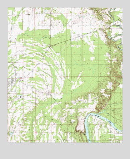
Orrville, AL USGS Topographic Map
Click on map above to begin viewing in our Map Viewer.

This topographic map contains these locations and features:
Feature Name Type Latitude Longitude GNIS ID View Map
Aimwell ChurchChurchN32.3551°W87.2039°112949View Map
Barnes CemeteryCemeteryN32.3515°W87.2489°113493View Map
BeloitPopulated PlaceN32.3543°W87.1486°154980View Map
Beloit Volunteer Fire DepartmentBuildingN32.3520°W87.1589°2691324View Map
Big Swamp BranchStreamN32.2810°W87.2133°114332View Map
Calhoun BendBendN32.2685°W87.1580°115395View Map
Calhoun Bend School (historical)SchoolN32.2638°W87.1414°144530View Map
Childers CreekStreamN32.3404°W87.1275°159390View Map
Church of the Immaculate ConceptionChurchN32.3099°W87.2317°144542View Map
First ChurchChurchN32.2960°W87.2417°144566View Map
Freewill ChurchChurchN32.2893°W87.1619°118636View Map
Fulton CemeteryCemeteryN32.3115°W87.2253°118756View Map
Gloss SchoolSchoolN32.3121°W87.2300°119053View Map
HazenPopulated PlaceN32.3401°W87.2039°119907View Map
Hopewell ChurchChurchN32.3493°W87.1444°144584View Map
Hurricane CreekStreamN32.3451°W87.2469°120596View Map
John the Baptist ChurchChurchN32.2529°W87.2072°144589View Map
John the Baptist SchoolSchoolN32.3032°W87.2064°120919View Map
Keith High SchoolSchoolN32.2918°W87.2358°121105View Map
Lake CemeteryCemeteryN32.2962°W87.1608°121314View Map
Liberty CemeteryCemeteryN32.2685°W87.1817°121533View Map
Lucy Gastrell BarBarN32.2676°W87.1658°144609View Map
Mary Taylor BarBarN32.2738°W87.1442°144611View Map
Mitchell BarBarN32.2646°W87.1339°144618View Map
Mount Calvary ChurchChurchN32.3546°W87.1564°144624View Map
New Home ChurchChurchN32.3460°W87.1778°152629View Map
OrrvillePopulated PlaceN32.3063°W87.2455°152821View Map
Orrville Baptist ChurchChurchN32.3071°W87.2436°1730136View Map
Orrville DivisionCivilN32.3283°W87.2123°165746View Map
Orrville Post OfficePost OfficeN32.3070°W87.2473°2788998View Map
Orrville Volunteer Fire DepartmentBuildingN32.3028°W87.2491°2691508View Map
Parnell CemeteryCemeteryN32.3726°W87.1489°152848View Map
Rosehill CemeteryCemeteryN32.3737°W87.1672°125943View Map
Shiloh ChapelChurchN32.2904°W87.1547°153414View Map
Shiloh ChurchChurchN32.2679°W87.1442°126734View Map
Siloam ChurchChurchN32.2915°W87.2386°144682View Map
Siloma ChurchChurchN32.2526°W87.1878°155506View Map
Silome SchoolSchoolN32.2518°W87.1875°126846View Map
Sugar Bottom CemeteryCemeteryN32.3629°W87.1405°127499View Map
The True Way ChurchChurchN32.3257°W87.2447°146087View Map
Threemile DitchCanalN32.2696°W87.1283°127951View Map
Town of OrrvilleCivilN32.3068°W87.2454°2407056View Map
Watts CemeteryCemeteryN32.2882°W87.1717°128648View Map
White Bluff BarBarN32.2693°W87.1644°146105View Map
Whites BluffCliffN32.2740°W87.1650°153967View Map
Whites BluffPopulated PlaceN32.2699°W87.1819°146106View Map

Note: Coordinates in the location and feature list above are referenced to NAD83 datum.


Copyright (C) 2008-2025 Ryan Niemi / Sunset Dynamics ... All Rights Reserved