TopoQuest Logo
Do you find TopoQuest useful?
Help keep TopoQuest running and adding new maps/features by donating!
Bitcoin:  19c7KJd3qBynnjoSw5npx9KScwjBe4ifkT
Litecoin:  LXs6TkuXGGXo1vDsWCkWVdjQX94eUKd6ui
Home View Maps Find Maps Find Places Resources & Links


Crumptonia, Alabama Topographic Map

USGS Map Title: Crumptonia, AL
USGS Map MRC: 32087B3
DRG (GeoTIFF) Download: o32087b3.tif


Neighboring USGS Topographic Map Quads:


  Central Mills, AL  
32087C4
 

  Safford, AL  
32087C3
 

  Orrville, AL  
32087C2
 

  Catherine, AL  
32087B4
 

  Crumptonia, AL  
32087B3
 

  Tasso, AL  
32087B2
 

  Lee Long Bridge, AL  
32087A4
 

  Camden North, AL  
32087A3
 

  Tilden, AL  
32087A2


Map MRC Location:

N33°
W88°
N33°
W87°
H8 H7 H6 H5 H4 H3 H2 H1
G8 G7 G6 G5 G4 G3 G2 G1
F8 F7 F6 F5 F4 F3 F2 F1
E8 E7 E6 E5 E4 E3 E2 E1
D8 D7 D6 D5 D4 D3 D2 D1
C8 C7 C6 C5 C4 C3 C2 C1
B8 B7 B6 B5 B4 B3 B2 B1
A8 A7 A6 A5 A4 A3 A2 A1
N32°
W88°
N32°
W87°

Crumptonia, AL USGS 1:24K Topographic Map Preview:
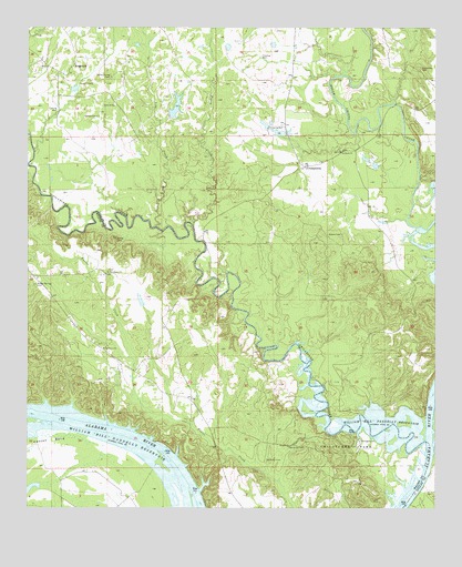
Crumptonia, AL USGS Topographic Map
Click on map above to begin viewing in our Map Viewer.

This topographic map contains these locations and features:
Feature Name Type Latitude Longitude GNIS ID View Map
Aeola Landing (historical)LocaleN32.1432°W87.3375°138413View Map
Aimwell ChurchChurchN32.2299°W87.3483°112947View Map
Athens Baptist ChurchChurchN32.2176°W87.2780°113270View Map
Athens CemeteryCemeteryN32.1960°W87.2825°113268View Map
Bennetts Store (historical)LocaleN32.1854°W87.3736°138427View Map
Cambridge Post Office (historical)Post OfficeN32.2143°W87.2894°166144View Map
Chilatchee CreekStreamN32.1426°W87.2522°158808View Map
Chilatchee ParkParkN32.1415°W87.2742°116039View Map
Cobbs CemeteryCemeteryN32.1949°W87.3475°116330View Map
Cobbs QuartersPopulated PlaceN32.2140°W87.3531°144544View Map
CrumptoniaPopulated PlaceN32.2138°W87.2894°156236View Map
Ellis (historical)LocaleN32.2043°W87.3575°144556View Map
Hardy Young CemeteryCemeteryN32.2376°W87.3492°119729View Map
Hennon CemeteryCemeteryN32.2268°W87.3530°119969View Map
Hogan CreekStreamN32.1993°W87.3244°120200View Map
Lize CreekStreamN32.1982°W87.3353°121931View Map
McMillan CemeteryCemeteryN32.1376°W87.3011°122591View Map
Morning Star Church (historical)ChurchN32.1254°W87.3700°138526View Map
Oak Grove CemeteryCemeteryN32.1410°W87.2892°124066View Map
Oak Grove ChurchChurchN32.1665°W87.3511°124084View Map
Oak Grove ChurchChurchN32.1418°W87.2930°138539View Map
Parks Landing (historical)LocaleN32.1354°W87.3367°138546View Map
Pine Grove ChurchChurchN32.1865°W87.3497°158902View Map
Poplar Springs CemeteryCemeteryN32.1832°W87.3725°125167View Map
Providence CemeteryCemeteryN32.2390°W87.2544°125319View Map
Providence Presbyterian ChurchChurchN32.2376°W87.2533°144649View Map
Red BluffCliffN32.1571°W87.2514°144652View Map
Retreat Post Office (historical)Post OfficeN32.1474°W87.3200°138563View Map
SedgefieldPopulated PlaceN32.2396°W87.3614°157036View Map
Sedgefield LakeReservoirN32.2294°W87.3297°130327View Map
Sedgefield Lake DamDamN32.2301°W87.3317°130326View Map
Sprague LandingLocaleN32.1263°W87.2572°144690View Map
Vaughn CemeteryCemeteryN32.2357°W87.3550°128420View Map
William 'Bill' Dannelly ReservoirReservoirN32.1452°W87.3611°128993View Map

Note: Coordinates in the location and feature list above are referenced to NAD83 datum.


Copyright (C) 2008-2024 Ryan Niemi / Sunset Dynamics ... All Rights Reserved