TopoQuest Logo
Do you find TopoQuest useful?
Help keep TopoQuest running and adding new maps/features by donating!
Bitcoin:  19c7KJd3qBynnjoSw5npx9KScwjBe4ifkT
Litecoin:  LXs6TkuXGGXo1vDsWCkWVdjQX94eUKd6ui
Home View Maps Find Maps Find Places Resources & Links


Tasso, Alabama Topographic Map

USGS Map Title: Tasso, AL
USGS Map MRC: 32087B2
DRG (GeoTIFF) Download: o32087b2.tif


Neighboring USGS Topographic Map Quads:


  Safford, AL  
32087C3
 

  Orrville, AL  
32087C2
 

  Blackwell Bend, AL  
32087C1
 

  Crumptonia, AL  
32087B3
 

  Tasso, AL  
32087B2
 

  Elm Bluff, AL  
32087B1
 

  Camden North, AL  
32087A3
 

  Tilden, AL  
32087A2
 

  Carlowville, AL  
32087A1


Map MRC Location:

N33°
W88°
N33°
W87°
H8 H7 H6 H5 H4 H3 H2 H1
G8 G7 G6 G5 G4 G3 G2 G1
F8 F7 F6 F5 F4 F3 F2 F1
E8 E7 E6 E5 E4 E3 E2 E1
D8 D7 D6 D5 D4 D3 D2 D1
C8 C7 C6 C5 C4 C3 C2 C1
B8 B7 B6 B5 B4 B3 B2 B1
A8 A7 A6 A5 A4 A3 A2 A1
N32°
W88°
N32°
W87°

Tasso, AL USGS 1:24K Topographic Map Preview:
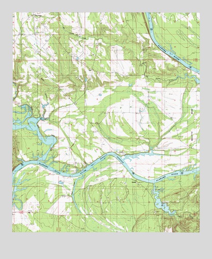
Tasso, AL USGS Topographic Map
Click on map above to begin viewing in our Map Viewer.

This topographic map contains these locations and features:
Feature Name Type Latitude Longitude GNIS ID View Map
Antioch ChurchChurchN32.2379°W87.2358°113140View Map
Bethel School (historical)SchoolN32.1988°W87.2086°144521View Map
Bogue Chitto CreekStreamN32.1665°W87.2330°159227View Map
Bogue Chitto Public Use AreaParkN32.1649°W87.2297°144526View Map
Cambridge ChurchChurchN32.2488°W87.2414°144532View Map
Cheerful Church Number 2ChurchN32.1943°W87.1486°115988View Map
Cheerful School (historical)SchoolN32.1946°W87.1486°144538View Map
EllisPopulated PlaceN32.1363°W87.2353°156307View Map
Five PointsPopulated PlaceN32.2488°W87.2355°118332View Map
Five Points Elementary SchoolSchoolN32.2440°W87.2272°144569View Map
Halls Ferry (historical)CrossingN32.1535°W87.1583°144579View Map
Lexington (historical)LocaleN32.1663°W87.2347°144598View Map
Lexington BarBarN32.1613°W87.2464°144599View Map
Little Zion ChurchChurchN32.2024°W87.1603°144605View Map
Little Zion ChurchChurchN32.1771°W87.1650°121915View Map
Lower Portland BarBarN32.1643°W87.1930°144607View Map
Lutheran School (historical)SchoolN32.1338°W87.2122°144610View Map
McMillan CemeteryCemeteryN32.1710°W87.1811°154767View Map
Meridith LakeReservoirN32.2001°W87.2300°130281View Map
Meridith Lake DamDamN32.2001°W87.2300°130282View Map
Middle Sister BarBarN32.1996°W87.1733°144616View Map
Molette Bend SchoolSchoolN32.1879°W87.1417°122935View Map
Molette CemeteryCemeteryN32.1743°W87.1328°122936View Map
Mount Pleasant ChurchChurchN32.1360°W87.1542°123362View Map
New Bethel CemeteryCemeteryN32.2071°W87.2192°123714View Map
New Bethel ChurchChurchN32.1985°W87.2086°152603View Map
Oak CreekStreamN32.1532°W87.1553°152722View Map
Pine Belt LandingLocaleN32.1699°W87.1811°144642View Map
PinebeltPopulated PlaceN32.1699°W87.1786°156897View Map
PortlandPopulated PlaceN32.1546°W87.1686°156921View Map
Portland Public Use AreaParkN32.1529°W87.1578°144646View Map
Providence ChurchChurchN32.2368°W87.2486°154764View Map
Providence SchoolSchoolN32.2368°W87.2486°125342View Map
Rifleman BarBarN32.2285°W87.1486°144653View Map
River Oaks MarinaLocaleN32.1585°W87.2078°144654View Map
River Oaks Volunteer Fire DepartmentBuildingN32.1714°W87.2113°2691301View Map
Rocky BranchStreamN32.1843°W87.2339°125798View Map
Rocky Branch ChurchChurchN32.2074°W87.2194°154766View Map
Rocky Branch SchoolSchoolN32.2071°W87.2192°125842View Map
Rum CreekStreamN32.1579°W87.2028°126014View Map
Seale CemeteryCemeteryN32.2129°W87.1978°154765View Map
Southwest Dallas Division (historical)CensusN32.1365°W87.2261°1935004View Map
TassoPopulated PlaceN32.2174°W87.1967°153653View Map
Turner Field CemeteryCemeteryN32.1712°W87.1653°128200View Map
Upper Portland BarBarN32.1585°W87.1389°146098View Map

Note: Coordinates in the location and feature list above are referenced to NAD83 datum.


Copyright (C) 2008-2025 Ryan Niemi / Sunset Dynamics ... All Rights Reserved