TopoQuest Logo
Do you find TopoQuest useful?
Help keep TopoQuest running and adding new maps/features by donating!
Bitcoin:  19c7KJd3qBynnjoSw5npx9KScwjBe4ifkT
Litecoin:  LXs6TkuXGGXo1vDsWCkWVdjQX94eUKd6ui
Home View Maps Find Maps Find Places Resources & Links


Browns, Alabama Topographic Map

USGS Map Title: Browns, AL
USGS Map MRC: 32087D3
DRG (GeoTIFF) Download: o32087d3.tif


Neighboring USGS Topographic Map Quads:


  Scott Station, AL  
32087E4
 

  Marion South, AL  
32087E3
 

  Suttle, AL  
32087E2
 

  Uniontown East, AL  
32087D4
 

  Browns, AL  
32087D3
 

  Marion Junction, AL  
32087D2
 

  Central Mills, AL  
32087C4
 

  Safford, AL  
32087C3
 

  Orrville, AL  
32087C2


Map MRC Location:

N33°
W88°
N33°
W87°
H8 H7 H6 H5 H4 H3 H2 H1
G8 G7 G6 G5 G4 G3 G2 G1
F8 F7 F6 F5 F4 F3 F2 F1
E8 E7 E6 E5 E4 E3 E2 E1
D8 D7 D6 D5 D4 D3 D2 D1
C8 C7 C6 C5 C4 C3 C2 C1
B8 B7 B6 B5 B4 B3 B2 B1
A8 A7 A6 A5 A4 A3 A2 A1
N32°
W88°
N32°
W87°

Browns, AL USGS 1:24K Topographic Map Preview:
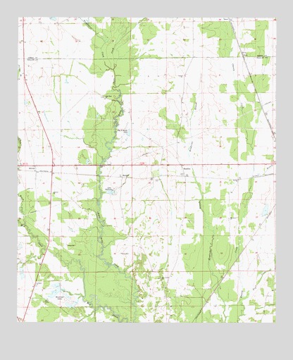
Browns, AL USGS Topographic Map
Click on map above to begin viewing in our Map Viewer.

This topographic map contains these locations and features:
Feature Name Type Latitude Longitude GNIS ID View Map
Bell CemeteriesCemeteryN32.3829°W87.3614°113852View Map
Bells ChurchChurchN32.3840°W87.3608°144519View Map
Big B Ranch LakeReservoirN32.4529°W87.3211°114217View Map
BrownsPopulated PlaceN32.4368°W87.3661°115005View Map
Brush CreekStreamN32.4151°W87.3711°115042View Map
C A Caines LakeReservoirN32.3865°W87.3465°130509View Map
C A Caines Lake DamDamN32.3868°W87.3450°130508View Map
Caldwell ChurchChurchN32.4282°W87.3581°115389View Map
Central Baptist ChurchChurchN32.4762°W87.2961°115885View Map
Dry CreekStreamN32.3851°W87.2658°117564View Map
E F Randell DamDamN32.4185°W87.2550°130550View Map
E F Randell LakeReservoirN32.4212°W87.2550°130551View Map
F W Pierce Lake Dam Number 2DamN32.3951°W87.3633°130521View Map
F W Pierce Lake Number 2ReservoirN32.3951°W87.3633°130520View Map
Gary School (historical)SchoolN32.4610°W87.2867°144574View Map
Gilmer BranchStreamN32.4346°W87.2622°118968View Map
Good Hope ChurchChurchN32.4676°W87.3339°119120View Map
Lake WalnuttaReservoirN32.4286°W87.3307°128558View Map
Macedonia ChurchChurchN32.4179°W87.2728°122155View Map
Marion Weissinger Lake Dam Number 2DamN32.3968°W87.3550°130523View Map
Marion Weissinger Lake Number 2ReservoirN32.3968°W87.3550°164453View Map
MarshallPopulated PlaceN32.4343°W87.3250°156660View Map
MassillonPopulated PlaceN32.4379°W87.2958°156667View Map
Mount Zion ChurchChurchN32.4335°W87.2681°123462View Map
NavePopulated PlaceN32.4860°W87.2669°156768View Map
New Vernon CemeteryCemeteryN32.3929°W87.3053°1805702View Map
New Vernon ChurchChurchN32.3932°W87.3053°123916View Map
Saint Chapter CemeteryCemeteryN32.3810°W87.3544°1805705View Map
Saint Chapter Primitive Baptist ChurchChurchN32.3812°W87.3542°154750View Map
Saint Marks ChurchChurchN32.3904°W87.3661°153265View Map
Vernon CemeteryCemeteryN32.3935°W87.3055°1805711View Map
W W Weissinger Lake Number 1ReservoirN32.3835°W87.3467°130506View Map
W W Weissinger Number 2 DamDamN32.3885°W87.3533°130513View Map
W W Weissinger Number 2 LakeReservoirN32.3875°W87.3564°130514View Map
W W Weissinger Number 4 DamDamN32.3968°W87.3733°130525View Map
W W Weissinger Number 4 LakeReservoirN32.3961°W87.3728°130524View Map
W W Wesssinger Number 1 DamDamN32.3835°W87.3467°130507View Map
Washington CreekStreamN32.4787°W87.3297°128612View Map
Weissinger LakesReservoirN32.3860°W87.3507°128715View Map

Note: Coordinates in the location and feature list above are referenced to NAD83 datum.


Copyright (C) 2008-2024 Ryan Niemi / Sunset Dynamics ... All Rights Reserved