TopoQuest Logo
Do you find TopoQuest useful?
Help keep TopoQuest running and adding new maps/features by donating!
Bitcoin:  19c7KJd3qBynnjoSw5npx9KScwjBe4ifkT
Litecoin:  LXs6TkuXGGXo1vDsWCkWVdjQX94eUKd6ui
Home View Maps Find Maps Find Places Resources & Links


Owasco, New York Topographic Map

USGS Map Title: Owasco, NY
USGS Map MRC: 42076G4
DRG (GeoTIFF) Download: o42076g4.tif


Neighboring USGS Topographic Map Quads:


  Auburn, NY  
42076H5
 

  Skaneateles, NY  
42076H4
 

  Marcellus, NY  
42076H3
 

  Scipio Center, NY  
42076G5
 

  Owasco, NY  
42076G4
 

  Spafford, NY  
42076G3
 

  Genoa, NY  
42076F5
 

  Moravia, NY  
42076F4
 

  Sempronius, NY  
42076F3


Map MRC Location:

N43°
W77°
N43°
W76°
H8 H7 H6 H5 H4 H3 H2 H1
G8 G7 G6 G5 G4 G3 G2 G1
F8 F7 F6 F5 F4 F3 F2 F1
E8 E7 E6 E5 E4 E3 E2 E1
D8 D7 D6 D5 D4 D3 D2 D1
C8 C7 C6 C5 C4 C3 C2 C1
B8 B7 B6 B5 B4 B3 B2 B1
A8 A7 A6 A5 A4 A3 A2 A1
N42°
W77°
N42°
W76°

Owasco, NY USGS 1:24K Topographic Map Preview:
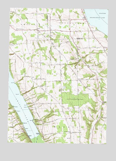
Owasco, NY USGS Topographic Map
Click on map above to begin viewing in our Map Viewer.

This topographic map contains these locations and features:
Feature Name Type Latitude Longitude GNIS ID View Map
Adams PointCapeN42.8048°W76.4919°942167View Map
AshlandPopulated PlaceN42.7628°W76.4780°942633View Map
AustinPopulated PlaceN42.8109°W76.4708°972182View Map
Birge PointCapeN42.7706°W76.4685°944032View Map
Burr PointCapeN42.8161°W76.4989°2541769View Map
CascadePopulated PlaceN42.7553°W76.4733°945943View Map
CasowascoPopulated PlaceN42.7834°W76.4938°972304View Map
Conklin CemeteryCemeteryN42.8414°W76.4909°947288View Map
Courtright CornersLocaleN42.7598°W76.4205°947565View Map
Dolphin PointCapeN42.7834°W76.4749°948556View Map
Dutch Hollow Country ClubLocaleN42.8609°W76.4591°2598508View Map
EdgewaterPopulated PlaceN42.7678°W76.4810°972441View Map
Folls Flower FarmLocaleN42.8214°W76.4511°2519346View Map
Globe Hotel CornersPopulated PlaceN42.7884°W76.3805°951261View Map
Hewitt CemeteryCemeteryN42.7698°W76.4563°952652View Map
Humphrey Howland CemeteryCemeteryN42.7582°W76.4943°2519247View Map
Indian CovePopulated PlaceN42.7717°W76.4677°953638View Map
MandanaPopulated PlaceN42.8656°W76.4035°956338View Map
Murphy FieldAirportN42.8383°W76.4396°2443540View Map
NilesPopulated PlaceN42.8376°W76.4135°958587View Map
Oak HillSummitN42.7548°W76.4224°959120View Map
OmroPopulated PlaceN42.7840°W76.4319°972894View Map
OwascoPopulated PlaceN42.8551°W76.4652°959665View Map
Owasco Fire Department Station 2BuildingN42.8536°W76.4632°2735029View Map
Owasco InletStreamN42.7553°W76.4635°959668View Map
Owasco Reformed ChurchChurchN42.8545°W76.4656°2597476View Map
Owasco Rural CemeteryCemeteryN42.8495°W76.4488°959671View Map
Rice PointCapeN42.7851°W76.4760°962455View Map
School Number 1 (historical)SchoolN42.7689°W76.4944°2120948View Map
School Number 1 (historical)SchoolN42.8331°W76.4747°2120949View Map
School Number 1 (historical)SchoolN42.8331°W76.4747°2120950View Map
School Number 10 (historical)SchoolN42.8097°W76.3869°2120960View Map
School Number 13 (historical)SchoolN42.8523°W76.4483°975058View Map
School Number 2 (historical)SchoolN42.7753°W76.3836°2120951View Map
School Number 2 (historical)SchoolN42.8078°W76.4706°2120952View Map
School Number 2 (historical)SchoolN42.8228°W76.4353°2120953View Map
School Number 2 (historical)SchoolN42.8525°W76.4619°2120954View Map
School Number 3 (historical)SchoolN42.7669°W76.4547°2120955View Map
School Number 3 (historical)SchoolN42.8422°W76.4156°2120956View Map
School Number 4 (historical)SchoolN42.7628°W76.4219°2120957View Map
School Number 4 (historical)SchoolN42.8401°W76.3802°975354View Map
School Number 5 (historical)SchoolN42.7872°W76.4358°2120958View Map
School Number 6 (historical)SchoolN42.8100°W76.4122°2120959View Map
School Number 7 (historical)SchoolN42.8587°W76.4994°975546View Map
School Number 9 (historical)SchoolN42.8656°W76.4050°2359191View Map
Seward PointCapeN42.7948°W76.4852°964888View Map
Southeast OwascoPopulated PlaceN42.7584°W76.4594°965902View Map
Town of NilesCivilN42.8127°W76.4059°979278View Map
Twelve CornersLocaleN42.8090°W76.4108°968018View Map
Twelve Corners CemeteryCemeteryN42.8028°W76.4020°968020View Map
Twin Birch FarmsLocaleN42.8658°W76.4336°2515538View Map
Valentine CornersLocaleN42.8545°W76.4841°968349View Map
West Niles Fire DepartmentBuildingN42.8096°W76.4700°2701313View Map
West Niles Rural CemeteryCemeteryN42.8025°W76.4606°970827View Map
Willow PointCapeN42.7792°W76.4888°971366View Map
WPCX-FM (Auburn)TowerN42.8015°W76.4369°978489View Map

Note: Coordinates in the location and feature list above are referenced to NAD83 datum.


Copyright (C) 2008-2025 Ryan Niemi / Sunset Dynamics ... All Rights Reserved