TopoQuest Logo
Do you find TopoQuest useful?
Help keep TopoQuest running and adding new maps/features by donating!
Bitcoin:  19c7KJd3qBynnjoSw5npx9KScwjBe4ifkT
Litecoin:  LXs6TkuXGGXo1vDsWCkWVdjQX94eUKd6ui
Home View Maps Find Maps Find Places Resources & Links


Oweep Creek, Utah Topographic Map

USGS Map Title: Oweep Creek, UT
USGS Map MRC: 40110F5
DRG (GeoTIFF) Download: o40110f5.tif


Neighboring USGS Topographic Map Quads:


  Red Knob, UT  
40110G6
 

  Mount Lovenia, UT  
40110G5
 

  Mount Powell, UT  
40110G4
 

  Explorer Peak, UT  
40110F6
 

  Oweep Creek, UT  
40110F5
 

  Garfield Basin, UT  
40110F4
 

  Tworoose Pass, UT  
40110E6
 

  Kidney Lake, UT  
40110E5
 

  Lake Fork Mountain, UT  
40110E4


Map MRC Location:

N41°
W111°
N41°
W110°
H8 H7 H6 H5 H4 H3 H2 H1
G8 G7 G6 G5 G4 G3 G2 G1
F8 F7 F6 F5 F4 F3 F2 F1
E8 E7 E6 E5 E4 E3 E2 E1
D8 D7 D6 D5 D4 D3 D2 D1
C8 C7 C6 C5 C4 C3 C2 C1
B8 B7 B6 B5 B4 B3 B2 B1
A8 A7 A6 A5 A4 A3 A2 A1
N40°
W111°
N40°
W110°

Oweep Creek, UT USGS 1:24K Topographic Map Preview:
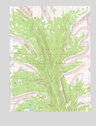
Oweep Creek, UT USGS Topographic Map
Click on map above to begin viewing in our Map Viewer.

This topographic map contains these locations and features:
Feature Name Type Latitude Longitude GNIS ID View Map
Brown Duck BasinBasinN40.6294°W110.5952°1426005View Map
Brown Duck MountainSummitN40.6366°W110.6191°1439166View Map
Clements CreekStreamN40.6313°W110.5485°1426709View Map
Clements LakeReservoirN40.6264°W110.5935°1434837View Map
Clements Lake DamDamN40.6277°W110.5880°1434838View Map
Cleveland LakeLakeN40.6794°W110.6250°1439807View Map
Cleveland PassGapN40.6805°W110.6243°1426715View Map
East BasinBasinN40.6602°W110.6029°1427660View Map
East Basin CreekStreamN40.6580°W110.5602°1427661View Map
East Basin PassGapN40.6411°W110.5752°1427662View Map
East Slide LakeLakeN40.6715°W110.5431°1427723View Map
High Uintas Primitive AreaAreaN40.7083°W110.5841°1454766View Map
Horseshoe LakeLakeN40.6464°W110.6207°1455327View Map
Lake Fork Forest Service StationLocaleN40.7380°W110.6071°1455361View Map
Lambert LakeLakeN40.7299°W110.5743°1429454View Map
Lambert MeadowFlatN40.7352°W110.5857°1429456View Map
Ottoson BasinBasinN40.6947°W110.6202°1444126View Map
Ottoson CreekStreamN40.6752°W110.5666°1444127View Map
Oweep CreekStreamN40.6652°W110.5618°1444130View Map
Picture LakeLakeN40.6574°W110.6201°1431221View Map
Stewart LakeLakeN40.6327°W110.5918°1432978View Map
Three LakesLakeN40.6714°W110.6077°1433490View Map
Twin LakesLakeN40.6269°W110.6112°1433739View Map
West ParkFlatN40.6527°W110.5127°1434104View Map

Note: Coordinates in the location and feature list above are referenced to NAD83 datum.


Copyright (C) 2008-2025 Ryan Niemi / Sunset Dynamics ... All Rights Reserved