TopoQuest Logo
Do you find TopoQuest useful?
Help keep TopoQuest running and adding new maps/features by donating!
Bitcoin:  19c7KJd3qBynnjoSw5npx9KScwjBe4ifkT
Litecoin:  LXs6TkuXGGXo1vDsWCkWVdjQX94eUKd6ui
Home View Maps Find Maps Find Places Resources & Links


Panther, Kentucky Topographic Map

USGS Map Title: Panther, KY
USGS Map MRC: 37087F2
DRG (GeoTIFF) Download: o37087f2.tif


Neighboring USGS Topographic Map Quads:


  Reed, KY  
37087G3
 

  Owensboro West, KY  
37087G2
 

  Owensboro East, KY  
37087G1
 

  Curdsville, KY  
37087F3
 

  Panther, KY  
37087F2
 

  Sutherland, KY  
37087F1
 

  Calhoun, KY  
37087E3
 

  Glenville, KY  
37087E2
 

  Utica, KY  
37087E1


Map MRC Location:

N38°
W88°
N38°
W87°
H8 H7 H6 H5 H4 H3 H2 H1
G8 G7 G6 G5 G4 G3 G2 G1
F8 F7 F6 F5 F4 F3 F2 F1
E8 E7 E6 E5 E4 E3 E2 E1
D8 D7 D6 D5 D4 D3 D2 D1
C8 C7 C6 C5 C4 C3 C2 C1
B8 B7 B6 B5 B4 B3 B2 B1
A8 A7 A6 A5 A4 A3 A2 A1
N37°
W88°
N37°
W87°

Panther, KY USGS 1:24K Topographic Map Preview:
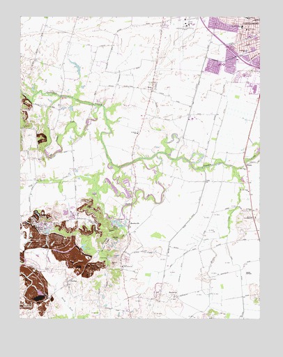
Panther, KY USGS Topographic Map
Click on map above to begin viewing in our Map Viewer.

This topographic map contains these locations and features:
Feature Name Type Latitude Longitude GNIS ID View Map
Albert Smith Marks birthplace Historical MarkerParkN37.7479°W87.1631°2744258View Map
Big DitchCanalN37.7189°W87.1583°487165View Map
Crow (historical)Populated PlaceN37.6699°W87.1288°2742920View Map
Daviess County Fire Department Airport StationBuildingN37.7482°W87.1632°2636812View Map
Daviess County Fire Department MosleyvilleBuildingN37.6593°W87.1962°2637042View Map
Dithey HillSummitN37.6709°W87.2156°490908View Map
Flat Lick CreekStreamN37.6778°W87.2094°492201View Map
Ford DitchCanalN37.6439°W87.1347°492307View Map
Geotz DitchCanalN37.7087°W87.1442°492792View Map
Goode AirparkAirportN37.6403°W87.1319°517496View Map
HandyvillePopulated PlaceN37.6350°W87.1703°508172View Map
HenryPopulated PlaceN37.6506°W87.2048°2742923View Map
Island FieldSummitN37.6764°W87.2108°495047View Map
Keller DitchCanalN37.7070°W87.1822°495612View Map
Lewis Lane ChurchChurchN37.7448°W87.1319°496334View Map
Miles AirportAirportN37.7069°W87.1579°517458View Map
Miller LakeLakeN37.6635°W87.1982°498349View Map
MoseleyvillePopulated PlaceN37.6631°W87.1933°498659View Map
Mount Zion ChurchChurchN37.6642°W87.2325°498937View Map
Nation HillSummitN37.6478°W87.2022°499183View Map
New Hope ChurchChurchN37.6870°W87.1319°499360View Map
Nickel RidgeRidgeN37.6559°W87.2058°499472View Map
Nickel Ridge ChurchChurchN37.6503°W87.2042°499473View Map
Oglesby HillSummitN37.6575°W87.2003°499778View Map
Old Panther CreekStreamN37.7167°W87.2289°499866View Map
Old Panther CreekStreamN37.6875°W87.1986°500154View Map
Owensboro-Daviess County Regional AirportAirportN37.7422°W87.1657°517456View Map
PantherPopulated PlaceN37.6400°W87.2250°500148View Map
Panther Creek Baptist ChurchChurchN37.6775°W87.1308°500160View Map
Panther Creek Battle Historical MarkerParkN37.6696°W87.1293°2744247View Map
PettitPopulated PlaceN37.6889°W87.1319°500485View Map
Rhodes CreekStreamN37.6881°W87.1394°501759View Map
RomePopulated PlaceN37.7212°W87.1808°502304View Map
Rushing ChurchChurchN37.6700°W87.1294°502496View Map
Russell HillSummitN37.6606°W87.2033°502527View Map
Saint Martin SchoolSchoolN37.7019°W87.1890°502684View Map
Saint Raphael (historical)Populated PlaceN37.7035°W87.2487°2742947View Map
Saint Raphael ChurchChurchN37.7037°W87.2483°502731View Map
SnyderPopulated PlaceN37.6472°W87.1971°2742949View Map
Snyder Consolidated SchoolSchoolN37.6467°W87.1967°503863View Map
Sutherland Consolidated SchoolSchoolN37.6667°W87.1272°504816View Map
Sutherland Hill (historical)SummitN37.6667°W87.1341°2742950View Map
Tamarack SchoolSchoolN37.7359°W87.1319°504930View Map
The Immaculate SchoolSchoolN37.7459°W87.1342°505123View Map
TuckPopulated PlaceN37.6817°W87.1531°509240View Map
Twin LakesPopulated PlaceN37.7178°W87.1571°2742952View Map
Utica-Stanley DivisionCivilN37.7021°W87.1928°1936972View Map
Vance DitchCanalN37.6448°W87.1658°505969View Map
Washington SchoolSchoolN37.7495°W87.1319°506250View Map
Windy HollowValleyN37.6727°W87.2234°506936View Map
Windy Hollow LakesReservoirN37.6611°W87.2361°506937View Map
Wolf Branch DitchCanalN37.6509°W87.1653°506990View Map
Zion HillSummitN37.6634°W87.2381°507294View Map

Note: Coordinates in the location and feature list above are referenced to NAD83 datum.


Copyright (C) 2008-2024 Ryan Niemi / Sunset Dynamics ... All Rights Reserved