TopoQuest Logo
Do you find TopoQuest useful?
Help keep TopoQuest running and adding new maps/features by donating!
Bitcoin:  19c7KJd3qBynnjoSw5npx9KScwjBe4ifkT
Litecoin:  LXs6TkuXGGXo1vDsWCkWVdjQX94eUKd6ui
Home View Maps Find Maps Find Places Resources & Links


Sutherland, Kentucky Topographic Map

USGS Map Title: Sutherland, KY
USGS Map MRC: 37087F1
DRG (GeoTIFF) Download: o37087f1.tif


Neighboring USGS Topographic Map Quads:


  Owensboro West, KY  
37087G2
 

  Owensboro East, KY  
37087G1
 

  Maceo, KY  
37086G8
 

  Panther, KY  
37087F2
 

  Sutherland, KY  
37087F1
 

  Philpot, KY  
37086F8
 

  Glenville, KY  
37087E2
 

  Utica, KY  
37087E1
 

  Pleasant Ridge, KY  
37086E8


Map MRC Location:

N38°
W88°
N38°
W87°
H8 H7 H6 H5 H4 H3 H2 H1
G8 G7 G6 G5 G4 G3 G2 G1
F8 F7 F6 F5 F4 F3 F2 F1
E8 E7 E6 E5 E4 E3 E2 E1
D8 D7 D6 D5 D4 D3 D2 D1
C8 C7 C6 C5 C4 C3 C2 C1
B8 B7 B6 B5 B4 B3 B2 B1
A8 A7 A6 A5 A4 A3 A2 A1
N37°
W88°
N37°
W87°

Sutherland, KY USGS 1:24K Topographic Map Preview:
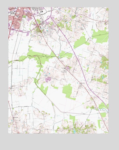
Sutherland, KY USGS Topographic Map
Click on map above to begin viewing in our Map Viewer.

This topographic map contains these locations and features:
Feature Name Type Latitude Longitude GNIS ID View Map
Bellevue ChurchChurchN37.7420°W87.1128°486812View Map
Brook Hill EstatesPopulated PlaceN37.7342°W87.0767°2742914View Map
Browns ValleyPopulated PlaceN37.6403°W87.1189°507596View Map
Burnett ForkStreamN37.7209°W87.0206°488447View Map
Daviess CountyCivilN37.7318°W87.0872°516876View Map
Daviess County Fire Department East StationBuildingN37.7399°W87.0248°2637319View Map
Daviess County Fire Department Masonville 1BuildingN37.6891°W87.0520°2636660View Map
Daviess County Historical MarkerParkN37.7290°W87.0861°2744282View Map
DermontPopulated PlaceN37.7437°W87.0408°490825View Map
Hickman (historical)Populated PlaceN37.6505°W87.1172°2742924View Map
Hix CemeteryCemeteryN37.6717°W87.1086°494318View Map
Holy Cross CemeteryCemeteryN37.7345°W87.0098°494450View Map
Horse ForkStreamN37.7017°W87.1014°494576View Map
Hunters RidgePopulated PlaceN37.7305°W87.0700°2742934View Map
Jackson FlatsFlatN37.7042°W87.0719°495122View Map
Kentucky Wesleyan CollegeSchoolN37.7447°W87.1209°495683View Map
Legion ParkParkN37.7406°W87.1050°496277View Map
Macedonia ChurchChurchN37.7359°W87.0378°497418View Map
MasonvillePopulated PlaceN37.6750°W87.0347°497667View Map
Masonville Census Designated PlaceCensusN37.6718°W87.0511°2403261View Map
Masonville SchoolSchoolN37.6895°W87.0542°497668View Map
Mitchell SchoolSchoolN37.7448°W87.1244°498455View Map
Newton Parrish SchoolSchoolN37.7409°W87.1139°499454View Map
North Fork Panther CreekStreamN37.7023°W87.0900°499562View Map
Oak RidgePopulated PlaceN37.7400°W87.0400°508730View Map
Our Lady of Lourdes SchoolSchoolN37.7317°W87.1189°500042View Map
Owensboro Fire Department Station 5BuildingN37.7356°W87.1245°2636611View Map
Rose Hill CemeteryCemeteryN37.7495°W87.0956°502337View Map
Saint Anthonys SchoolSchoolN37.6445°W87.1153°502579View Map
Shoemaker BranchStreamN37.6717°W87.0883°503407View Map
South Fork Panther CreekStreamN37.7023°W87.0897°503939View Map
Southern Junior High SchoolSchoolN37.7487°W87.1242°504001View Map
Southern Junior High SchoolSchoolN37.7487°W87.1250°504002View Map
Southside SchoolSchoolN37.7420°W87.0947°504009View Map
Sugar Grove Baptist ChurchChurchN37.6505°W87.0156°504664View Map
SutherlandPopulated PlaceN37.6700°W87.1211°504815View Map
Twomile CreekStreamN37.6562°W87.0706°505732View Map
Windridge Country ClubLocaleN37.7289°W87.0342°517308View Map
WKWC-FM (Owensboro)TowerN37.7437°W87.1200°517728View Map
WOMI-AM (Owensboro)TowerN37.7414°W87.1161°517648View Map

Note: Coordinates in the location and feature list above are referenced to NAD83 datum.


Copyright (C) 2008-2024 Ryan Niemi / Sunset Dynamics ... All Rights Reserved