TopoQuest Logo
Do you find TopoQuest useful?
Help keep TopoQuest running and adding new maps/features by donating!
Bitcoin:  19c7KJd3qBynnjoSw5npx9KScwjBe4ifkT
Litecoin:  LXs6TkuXGGXo1vDsWCkWVdjQX94eUKd6ui
Home View Maps Find Maps Find Places Resources & Links


Park Spring, North Carolina Topographic Map

USGS Map Title: Park Spring, NC
USGS Map MRC: 36079D4
DRG (GeoTIFF) Download: o36079d4.tif


Neighboring USGS Topographic Map Quads:


  Brosville, VA  
36079E5
 

  Danville, VA  
36079E4
 

  Ringgold, VA  
36079E3
 

  Ruffin, NC  
36079D5
 

  Park Spring, NC  
36079D4
 

  Yanceyville, NC  
36079D3
 

  Williamsburg, NC  
36079C5
 

  Cherry Grove, NC  
36079C4
 

  Anderson, NC  
36079C3


Map MRC Location:

N37°
W80°
N37°
W79°
H8 H7 H6 H5 H4 H3 H2 H1
G8 G7 G6 G5 G4 G3 G2 G1
F8 F7 F6 F5 F4 F3 F2 F1
E8 E7 E6 E5 E4 E3 E2 E1
D8 D7 D6 D5 D4 D3 D2 D1
C8 C7 C6 C5 C4 C3 C2 C1
B8 B7 B6 B5 B4 B3 B2 B1
A8 A7 A6 A5 A4 A3 A2 A1
N36°
W80°
N36°
W79°

Park Spring, NC USGS 1:24K Topographic Map Preview:
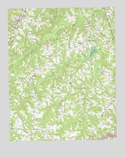
Park Spring, NC USGS Topographic Map
Click on map above to begin viewing in our Map Viewer.

This topographic map contains these locations and features:
Feature Name Type Latitude Longitude GNIS ID View Map
AllisonPopulated PlaceN36.4090°W79.4642°980145View Map
Bear BranchStreamN36.4729°W79.3792°980697View Map
BethelPopulated PlaceN36.4535°W79.4517°981098View Map
Bethesda ChurchChurchN36.3779°W79.4753°981197View Map
BlackwellPopulated PlaceN36.4426°W79.4636°981563View Map
Blackwell ChurchChurchN36.3785°W79.4050°981565View Map
Caswell AirportAirportN36.4005°W79.3914°998066View Map
Cedar Grove ChurchChurchN36.3860°W79.3964°982856View Map
Cobb Memorial SchoolSchoolN36.4362°W79.4714°983317View Map
Cobbs ShopLocaleN36.3829°W79.4789°1023528View Map
Duncan Elementary SchoolSchoolN36.4285°W79.4275°1006470View Map
East Prong Moon CreekStreamN36.4596°W79.3922°984527View Map
Gwynns ChapelChurchN36.4701°W79.4936°986276View Map
JonesPopulated PlaceN36.4293°W79.4300°1020976View Map
Little Mill CreekStreamN36.4851°W79.4381°988707View Map
Mineral Spring ChurchChurchN36.4249°W79.4153°990046View Map
New Ephesus ChurchChurchN36.3862°W79.4714°990964View Map
Park SpringPopulated PlaceN36.4660°W79.4128°991854View Map
Park Spring LakeReservoirN36.4685°W79.3975°991855View Map
Pelham Post OfficePost OfficeN36.4848°W79.4858°2774226View Map
QuickPopulated PlaceN36.4054°W79.4964°992951View Map
SwannPopulated PlaceN36.4915°W79.4831°995756View Map
Township of Locust HillCivilN36.4000°W79.4587°1026518View Map
Township of PelhamCivilN36.4949°W79.4522°1026520View Map
True Gospel ChurchChurchN36.4924°W79.4814°996272View Map
West Prong Moon CreekStreamN36.4179°W79.4114°997039View Map
West YanceyvillePopulated PlaceN36.4062°W79.3870°997053View Map
Wildwood LakeReservoirN36.4578°W79.4009°997322View Map
Wildwood Lake DamDamN36.4607°W79.3967°1000657View Map
Yanceyville Fire Department Station 2BuildingN36.4007°W79.3907°2639015View Map

Note: Coordinates in the location and feature list above are referenced to NAD83 datum.


Copyright (C) 2008-2024 Ryan Niemi / Sunset Dynamics ... All Rights Reserved