TopoQuest Logo
Do you find TopoQuest useful?
Help keep TopoQuest running and adding new maps/features by donating!
Bitcoin:  19c7KJd3qBynnjoSw5npx9KScwjBe4ifkT
Litecoin:  LXs6TkuXGGXo1vDsWCkWVdjQX94eUKd6ui
Home View Maps Find Maps Find Places Resources & Links


Ruffin, North Carolina Topographic Map

USGS Map Title: Ruffin, NC
USGS Map MRC: 36079D5
DRG (GeoTIFF) Download: o36079d5.tif


Neighboring USGS Topographic Map Quads:


  Northeast Eden, NC  
36079E6
 

  Brosville, VA  
36079E5
 

  Danville, VA  
36079E4
 

  Southeast Eden, NC  
36079D6
 

  Ruffin, NC  
36079D5
 

  Park Spring, NC  
36079D4
 

  Reidsville, NC  
36079C6
 

  Williamsburg, NC  
36079C5
 

  Cherry Grove, NC  
36079C4


Map MRC Location:

N37°
W80°
N37°
W79°
H8 H7 H6 H5 H4 H3 H2 H1
G8 G7 G6 G5 G4 G3 G2 G1
F8 F7 F6 F5 F4 F3 F2 F1
E8 E7 E6 E5 E4 E3 E2 E1
D8 D7 D6 D5 D4 D3 D2 D1
C8 C7 C6 C5 C4 C3 C2 C1
B8 B7 B6 B5 B4 B3 B2 B1
A8 A7 A6 A5 A4 A3 A2 A1
N36°
W80°
N36°
W79°

Ruffin, NC USGS 1:24K Topographic Map Preview:
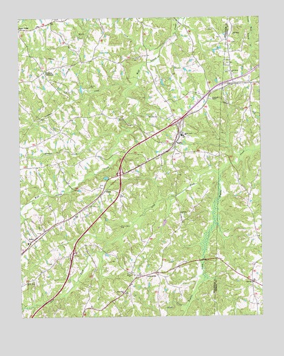
Ruffin, NC USGS Topographic Map
Click on map above to begin viewing in our Map Viewer.

This topographic map contains these locations and features:
Feature Name Type Latitude Longitude GNIS ID View Map
BHH Aviation AirportAirportN36.4756°W79.5957°2717294View Map
Birch ForkStreamN36.4910°W79.5475°981495View Map
CasvillePopulated PlaceN36.3901°W79.5042°1019556View Map
Casville Volunteer Fire DepartmentBuildingN36.3893°W79.5037°2639216View Map
Guerrant SpringsSpringN36.4693°W79.6003°1953420View Map
Guerrant Springs (historical)Populated PlaceN36.4696°W79.5995°1953421View Map
Jones CreekStreamN36.3799°W79.5384°987750View Map
LawsonvillePopulated PlaceN36.3929°W79.5636°988231View Map
LevivaPopulated PlaceN36.3979°W79.5797°1953410View Map
Lick ForkStreamN36.4360°W79.5192°988455View Map
Lick Fork Primitive Baptist ChurchChurchN36.4187°W79.5411°988456View Map
Lively Stones Baptist ChurchChurchN36.4776°W79.5153°988818View Map
Lovelace CreekStreamN36.4710°W79.5667°989061View Map
Martin CemeteryCemeteryN36.4715°W79.5875°989396View Map
Mount Hermon Baptist ChurchChurchN36.4587°W79.5531°990412View Map
Mullins-Stacy CemeteryCemeteryN36.4129°W79.5722°990790View Map
Narrow Gauge ChurchChurchN36.3899°W79.6214°990862View Map
Oak Grove Primitive Baptist ChurchChurchN36.3932°W79.5675°991401View Map
Oakhaven FarmsPopulated PlaceN36.4687°W79.5322°1953412View Map
Peniel Methodist Church (historical)ChurchN36.3929°W79.5684°1953413View Map
Poteat School (historical)SchoolN36.4829°W79.5861°1953414View Map
Quaqua CreekStreamN36.4507°W79.5734°992936View Map
Rocky Ridge Baptist ChurchChurchN36.3851°W79.5703°993616View Map
RuffinPopulated PlaceN36.4471°W79.5439°1022440View Map
Ruffin CemeteryCemeteryN36.4515°W79.5409°1953415View Map
Ruffin Census Designated PlaceCensusN36.4428°W79.5433°2628654View Map
Ruffin High SchoolSchoolN36.4510°W79.5406°1953416View Map
Ruffin Post OfficePost OfficeN36.4504°W79.5436°2773775View Map
Ruffin Volunteer Fire DepartmentBuildingN36.4469°W79.5453°2638448View Map
SadlerPopulated PlaceN36.4087°W79.6170°1022457View Map
Sadler Elementary SchoolSchoolN36.4062°W79.6206°1007242View Map
Shiloh ChurchChurchN36.4179°W79.5948°994714View Map
StaceyPopulated PlaceN36.4282°W79.5814°1022762View Map
Stephens CrossroadsPopulated PlaceN36.4776°W79.6111°1022789View Map
Township of RuffinCivilN36.4656°W79.5949°1027137View Map
Wolf Island ChurchChurchN36.4932°W79.5134°997530View Map

Note: Coordinates in the location and feature list above are referenced to NAD83 datum.


Copyright (C) 2008-2025 Ryan Niemi / Sunset Dynamics ... All Rights Reserved