TopoQuest Logo
Do you find TopoQuest useful?
Help keep TopoQuest running and adding new maps/features by donating!
Bitcoin:  19c7KJd3qBynnjoSw5npx9KScwjBe4ifkT
Litecoin:  LXs6TkuXGGXo1vDsWCkWVdjQX94eUKd6ui
Home View Maps Find Maps Find Places Resources & Links


Bergoo, West Virginia Topographic Map

USGS Map Title: Bergoo, WV
USGS Map MRC: 38080D3
DRG (GeoTIFF) Download: o38080d3.tif


Neighboring USGS Topographic Map Quads:


  Diana, WV  
38080E4
 

  Skelt, WV  
38080E3
 

  Samp, WV  
38080E2
 

  Webster Springs, WV  
38080D4
 

  Bergoo, WV  
38080D3
 

  Sharp Knob, WV  
38080D2
 

  Webster Springs SW, WV  
38080C4
 

  Webster Springs SE, WV  
38080C3
 

  Woodrow, WV  
38080C2


Map MRC Location:

N39°
W81°
N39°
W80°
H8 H7 H6 H5 H4 H3 H2 H1
G8 G7 G6 G5 G4 G3 G2 G1
F8 F7 F6 F5 F4 F3 F2 F1
E8 E7 E6 E5 E4 E3 E2 E1
D8 D7 D6 D5 D4 D3 D2 D1
C8 C7 C6 C5 C4 C3 C2 C1
B8 B7 B6 B5 B4 B3 B2 B1
A8 A7 A6 A5 A4 A3 A2 A1
N38°
W81°
N38°
W80°

Bergoo, WV USGS 1:24K Topographic Map Preview:
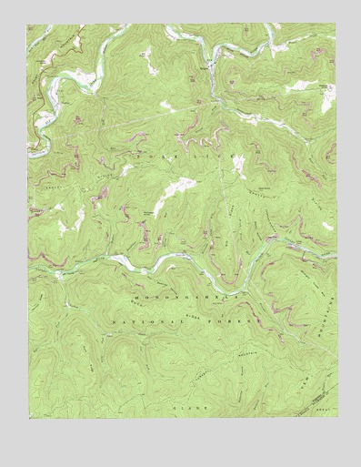
Bergoo, WV USGS Topographic Map
Click on map above to begin viewing in our Map Viewer.

This topographic map contains these locations and features:
Feature Name Type Latitude Longitude GNIS ID View Map
Ash Beetree HollowValleyN38.4204°W80.3265°1550118View Map
Baughman RunStreamN38.4265°W80.3401°1550179View Map
BergooPopulated PlaceN38.4865°W80.3006°1553865View Map
Bergoo Census Designated PlaceCensusN38.4849°W80.2981°2586761View Map
Bergoo CreekStreamN38.4937°W80.2767°1550265View Map
Bergoo Post OfficePost OfficeN38.4869°W80.3007°1727824View Map
Big RidgeRidgeN38.4337°W80.2926°1550306View Map
Big RunStreamN38.4143°W80.2954°1550317View Map
Bill KnobSummitN38.4898°W80.3270°1550355View Map
Bill Knob School (historical)SchoolN38.4851°W80.3240°1727828View Map
Blazed ForkStreamN38.4746°W80.2962°1550385View Map
Brush Fence RunStreamN38.4243°W80.2845°1550496View Map
Buck RidgeRidgeN38.4090°W80.3167°1550526View Map
Coal ForkStreamN38.4012°W80.3298°1550736View Map
Cold KnobSummitN38.4468°W80.2815°1550755View Map
CurtinPopulated PlaceN38.4746°W80.3626°1554245View Map
Curtin Census Designated PlaceCensusN38.4720°W80.3573°2586794View Map
Deep RunStreamN38.4596°W80.3659°1550897View Map
Dilly ForkStreamN38.4026°W80.3442°1550928View Map
Drybed RunStreamN38.4929°W80.3734°1550990View Map
Fork RidgeRidgeN38.3946°W80.3501°1551160View Map
Gauley DivideRidgeN38.4498°W80.3062°1551211View Map
Gwen Wyatt SpringSpringN38.4779°W80.3467°1678171View Map
Hughes RunStreamN38.4265°W80.3445°1551517View Map
Hughes Run School (historical)SchoolN38.4529°W80.3173°1727866View Map
JerryvillePopulated PlaceN38.4257°W80.3112°1554806View Map
Joe RunStreamN38.4315°W80.2748°1551584View Map
Johnson HollowValleyN38.4334°W80.2759°1551599View Map
Jonathan KnobSummitN38.4879°W80.3667°1554826View Map
Leatherwood CreekStreamN38.4873°W80.3006°1551760View Map
Meadowland CemeteryCemeteryN38.4904°W80.2942°1552051View Map
Mill RunStreamN38.4796°W80.3495°1552119View Map
Mill Run School (historical)SchoolN38.4779°W80.3470°1727880View Map
ParcoalPopulated PlaceN38.4593°W80.3734°1555304View Map
Parcoal Census Designated PlaceCensusN38.4605°W80.3732°2586864View Map
Pleasant Grove ChurchChurchN38.4837°W80.3667°1552496View Map
Pompeys KnobSummitN38.4398°W80.3284°1555386View Map
RalphPopulated PlaceN38.4773°W80.3687°1552580View Map
Redoak KnobSummitN38.4793°W80.2531°1552624View Map
Redoak School (historical)SchoolN38.4779°W80.2551°1727904View Map
Right Fork Leatherwood CreekStreamN38.4615°W80.2612°1552661View Map
Right Fork Turkey CreekStreamN38.4101°W80.3576°1552665View Map
Rocky HollowValleyN38.4307°W80.2804°1552711View Map
Saint Marys School (historical)SchoolN38.4854°W80.3673°1727908View Map
Spring RunStreamN38.4265°W80.3192°1553007View Map
Straight CreekStreamN38.4157°W80.2884°1553091View Map
Straight Creek MountainRidgeN38.4182°W80.2604°1553092View Map
Turkey CreekStreamN38.4215°W80.3601°1553283View Map
Turkey Mountain TrailTrailN38.3818°W80.3540°1553618View Map
Twin Branch TrailTrailN38.3779°W80.3592°1553617View Map
Union Cemetery CemeteryN38.4774°W80.3613°2729251View Map
Union Cemetery CemeteryN38.4611°W80.3675°2729252View Map
Williams Camp RunStreamN38.4265°W80.3098°1553460View Map

Note: Coordinates in the location and feature list above are referenced to NAD83 datum.


Copyright (C) 2008-2024 Ryan Niemi / Sunset Dynamics ... All Rights Reserved