TopoQuest Logo
Do you find TopoQuest useful?
Help keep TopoQuest running and adding new maps/features by donating!
Bitcoin:  19c7KJd3qBynnjoSw5npx9KScwjBe4ifkT
Litecoin:  LXs6TkuXGGXo1vDsWCkWVdjQX94eUKd6ui
Home View Maps Find Maps Find Places Resources & Links


Webster Springs SE, West Virginia Topographic Map

USGS Map Title: Webster Springs SE, WV
USGS Map MRC: 38080C3
DRG (GeoTIFF) Download: o38080c3.tif


Neighboring USGS Topographic Map Quads:


  Webster Springs, WV  
38080D4
 

  Bergoo, WV  
38080D3
 

  Sharp Knob, WV  
38080D2
 

  Webster Springs SW, WV  
38080C4
 

  Webster Springs SE, WV  
38080C3
 

  Woodrow, WV  
38080C2
 

  Fork Mountain, WV  
38080B4
 

  Lobelia, WV  
38080B3
 

  Hillsboro, WV  
38080B2


Map MRC Location:

N39°
W81°
N39°
W80°
H8 H7 H6 H5 H4 H3 H2 H1
G8 G7 G6 G5 G4 G3 G2 G1
F8 F7 F6 F5 F4 F3 F2 F1
E8 E7 E6 E5 E4 E3 E2 E1
D8 D7 D6 D5 D4 D3 D2 D1
C8 C7 C6 C5 C4 C3 C2 C1
B8 B7 B6 B5 B4 B3 B2 B1
A8 A7 A6 A5 A4 A3 A2 A1
N38°
W81°
N38°
W80°

Webster Springs SE, WV USGS 1:24K Topographic Map Preview:
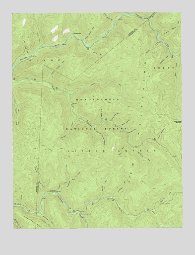
Webster Springs SE, WV USGS Topographic Map
Click on map above to begin viewing in our Map Viewer.

This topographic map contains these locations and features:
Feature Name Type Latitude Longitude GNIS ID View Map
Bannock Shoals RunStreamN38.3623°W80.2662°1550166View Map
Beechy RunStreamN38.3273°W80.3331°1550252View Map
Big Beechy TrailTrailN38.3218°W80.2920°1550283View Map
Birchlog RunStreamN38.2687°W80.3526°1550363View Map
Birchlog TrailTrailN38.2815°W80.3559°1550364View Map
Bridge CreekStreamN38.3587°W80.2665°1550455View Map
Cashcamp RunStreamN38.2679°W80.3023°1550642View Map
Coal RunStreamN38.2998°W80.2904°1550739View Map
County Line TrailTrailN38.3459°W80.2976°1553567View Map
Cranberry WildernessReserveN38.2946°W80.3132°1553564View Map
District Line TrailTrailN38.3309°W80.2759°1553581View Map
Elbow RunStreamN38.3554°W80.3170°1551024View Map
Hammond RunStreamN38.3048°W80.2904°1551341View Map
Hateful RunStreamN38.3512°W80.2579°1551388View Map
Hell for Certain BranchStreamN38.3096°W80.3151°1551407View Map
Houselog RunStreamN38.2593°W80.3567°1551509View Map
Hunting RunStreamN38.2673°W80.3106°1551532View Map
Kennison MountainSummitN38.2529°W80.3592°1554862View Map
Kens CreekStreamN38.3496°W80.2540°1551654View Map
Laurelly BranchStreamN38.3143°W80.3284°1551750View Map
Laurelly Branch TrailTrailN38.3087°W80.3284°1553563View Map
Left Fork North Fork Cranberry RiverStreamN38.2604°W80.2712°1551773View Map
Little Bannock Shoals RunStreamN38.3715°W80.2737°1551829View Map
Little Beechy RunStreamN38.3348°W80.3490°1551834View Map
Little Elbow RunStreamN38.3587°W80.3217°1551850View Map
Little Fork TrailTrailN38.3176°W80.3704°1551855View Map
Little Lick BranchStreamN38.3698°W80.2987°1551871View Map
McClintock RunStreamN38.2962°W80.2842°1552023View Map
Middle Fork TrailTrailN38.3121°W80.3045°1553566View Map
Mill RunStreamN38.3551°W80.3545°1552130View Map
North Branch Middle Fork Williams RiverStreamN38.3004°W80.2690°1552316View Map
North Fork Cranberry RiverStreamN38.2579°W80.3242°1552331View Map
North Fork TrailTrailN38.2607°W80.2781°1553565View Map
North South TrailTrailN38.2973°W80.3262°1552597View Map
Norton RunStreamN38.2643°W80.3701°1552348View Map
Red Lick RunStreamN38.3490°W80.3640°1552606View Map
Rocklick RunStreamN38.3743°W80.2842°1552708View Map
Sheets Gordon RunStreamN38.3126°W80.3084°1552858View Map
Slabcamp BranchStreamN38.3743°W80.2934°1552911View Map
Slade BranchStreamN38.3090°W80.2945°1552919View Map
Slick Rock RunStreamN38.3126°W80.3015°1552929View Map
South Fork Cranberry RiverStreamN38.2579°W80.3242°1553558View Map
Sugar Creek MountainSummitN38.3065°W80.2515°1553114View Map
Tumbling Rock Camping ShelterLocaleN38.2712°W80.3451°1553280View Map
Tumbling Rock RunStreamN38.2712°W80.3429°1553281View Map
Tumbling Rock TrailTrailN38.2821°W80.3340°1553282View Map
Twin BranchesLocaleN38.3629°W80.3301°1553296View Map
Yew MountainsRangeN38.2643°W80.2913°1553535View Map

Note: Coordinates in the location and feature list above are referenced to NAD83 datum.


Copyright (C) 2008-2025 Ryan Niemi / Sunset Dynamics ... All Rights Reserved