TopoQuest Logo
Do you find TopoQuest useful?
Help keep TopoQuest running and adding new maps/features by donating!
Bitcoin:  19c7KJd3qBynnjoSw5npx9KScwjBe4ifkT
Litecoin:  LXs6TkuXGGXo1vDsWCkWVdjQX94eUKd6ui
Home View Maps Find Maps Find Places Resources & Links


Parowan, Utah Topographic Map

USGS Map Title: Parowan, UT
USGS Map MRC: 37112G7
DRG (GeoTIFF) Download: o37112g7.tif


Neighboring USGS Topographic Map Quads:


  Parowan Gap, UT  
37112H8
 

  Paragonah, UT  
37112H7
 

  Cottonwood Mountain, UT  
37112H6
 

  Summit, UT  
37112G8
 

  Parowan, UT  
37112G7
 

  Red Creek Reservoir, UT  
37112G6
 

  Flanigan Arch, UT  
37112F8
 

  Brian Head, UT  
37112F7
 

  Panguitch Lake, UT  
37112F6


Map MRC Location:

N38°
W113°
N38°
W112°
H8 H7 H6 H5 H4 H3 H2 H1
G8 G7 G6 G5 G4 G3 G2 G1
F8 F7 F6 F5 F4 F3 F2 F1
E8 E7 E6 E5 E4 E3 E2 E1
D8 D7 D6 D5 D4 D3 D2 D1
C8 C7 C6 C5 C4 C3 C2 C1
B8 B7 B6 B5 B4 B3 B2 B1
A8 A7 A6 A5 A4 A3 A2 A1
N37°
W113°
N37°
W112°

Parowan, UT USGS 1:24K Topographic Map Preview:
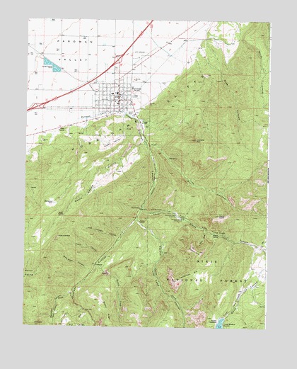
Parowan, UT USGS Topographic Map
Click on map above to begin viewing in our Map Viewer.

This topographic map contains these locations and features:
Feature Name Type Latitude Longitude GNIS ID View Map
Alum CoveValleyN37.7903°W112.7830°1438185View Map
Assembly of Jesus ChristChurchN37.8444°W112.8466°1449221View Map
Benson CreekStreamN37.7753°W112.8369°1438610View Map
Billy West CanyonValleyN37.7728°W112.8411°1438776View Map
Bowery CreekStreamN37.8000°W112.8133°1439052View Map
Boy Scouts of America CampLocaleN37.7639°W112.8499°1448173View Map
Center CreekStreamN37.7972°W112.8174°1439612View Map
City of ParowanCivilN37.8326°W112.8296°2411378View Map
Dry CanyonValleyN37.8255°W112.8136°1440582View Map
Dry Lakes CreekStreamN37.7625°W112.8508°1440673View Map
First Left Hand CanyonValleyN37.7980°W112.8149°1441055View Map
First MoundSummitN37.8297°W112.8555°1441057View Map
Free Thought CanyonValleyN37.7858°W112.8274°1441223View Map
Grand CastlePillarN37.7958°W112.7758°1441401View Map
Grass ValleyBasinN37.8250°W112.8316°1441429View Map
Henderson HillSummitN37.7711°W112.7880°1441701View Map
Hole in the RockSummitN37.7869°W112.8577°1441807View Map
Hyatt CanyonValleyN37.7783°W112.8358°1441962View Map
Iron County Ambulance - ParowanBuildingN37.8537°W112.8223°2665430View Map
Mahogany SeepSpringN37.8002°W112.8611°1443096View Map
Maple SpringSpringN37.7953°W112.8551°1443180View Map
Maple Spring HollowValleyN37.8250°W112.8161°1443185View Map
Moseman CanyonValleyN37.7633°W112.8511°1443613View Map
Noahs ArkSummitN37.7808°W112.7852°1443836View Map
Order CanyonValleyN37.8591°W112.7833°1444104View Map
P HillSummitN37.8300°W112.8208°1444330View Map
ParowanPopulated PlaceN37.8422°W112.8280°1444224View Map
Parowan AirportAirportN37.8585°W112.8198°1447592View Map
Parowan CanyonValleyN37.8353°W112.8199°1444225View Map
Parowan City CemeteryCemeteryN37.8375°W112.8180°1448813View Map
Parowan Elementary SchoolSchoolN37.8448°W112.8309°1448816View Map
Parowan Fire DepartmentBuildingN37.8391°W112.8313°2627422View Map
Parowan High SchoolSchoolN37.8458°W112.8284°1448815View Map
Parowan Police DepartmentBuildingN37.8420°W112.8272°2730382View Map
Parowan Post OfficePost OfficeN37.8414°W112.8304°1455451View Map
Second Left Hand CanyonValleyN37.7936°W112.8172°1445406View Map
Sixmile SpringSpringN37.7874°W112.7750°1445629View Map
Sols SpringSpringN37.8188°W112.8021°1445782View Map
The Church of Jesus Christ of Latter Day SaintsChurchN37.8416°W112.8297°1449585View Map
The Church of Jesus Christ of Latter Day SaintsChurchN37.8408°W112.8286°1449586View Map
The ForebayLakeN37.7984°W112.8151°1446447View Map
Valentine PeakSummitN37.8264°W112.7880°1446904View Map
Vermillion CastlePillarN37.7969°W112.8074°1446928View Map
Vermillion Castle CampgroundLocaleN37.7955°W112.7974°1446929View Map
Vermillion Castle Guard StationLocaleN37.7953°W112.7974°1446930View Map
Water CanyonValleyN37.8672°W112.7655°1447040View Map
White HillSummitN37.7508°W112.8669°1447249View Map
Yankee MeadowsFlatN37.7530°W112.7752°1447546View Map
Yankee Meadows DamDamN37.7539°W112.7722°1447648View Map
Yankee Meadows ReservoirReservoirN37.7508°W112.7740°1447647View Map

Note: Coordinates in the location and feature list above are referenced to NAD83 datum.


Copyright (C) 2008-2025 Ryan Niemi / Sunset Dynamics ... All Rights Reserved