TopoQuest Logo
Do you find TopoQuest useful?
Help keep TopoQuest running and adding new maps/features by donating!
Bitcoin:  19c7KJd3qBynnjoSw5npx9KScwjBe4ifkT
Litecoin:  LXs6TkuXGGXo1vDsWCkWVdjQX94eUKd6ui
Home View Maps Find Maps Find Places Resources & Links


Leary, Georgia Topographic Map

USGS Map Title: Leary, GA
USGS Map MRC: 31084D5
DRG (GeoTIFF) Download: o31084d5.tif


Neighboring USGS Topographic Map Quads:


  Edison, GA  
31084E6
 

  Morgan, GA  
31084E5
 

  Holt, GA  
31084E4
 

  Arlington, GA  
31084D6
 

  Leary, GA  
31084D5
 

  Bermuda, GA  
31084D4
 

  Damascus, GA  
31084C6
 

  Bethany, GA  
31084C5
 

  Elmodel, GA  
31084C4


Map MRC Location:

N32°
W85°
N32°
W84°
H8 H7 H6 H5 H4 H3 H2 H1
G8 G7 G6 G5 G4 G3 G2 G1
F8 F7 F6 F5 F4 F3 F2 F1
E8 E7 E6 E5 E4 E3 E2 E1
D8 D7 D6 D5 D4 D3 D2 D1
C8 C7 C6 C5 C4 C3 C2 C1
B8 B7 B6 B5 B4 B3 B2 B1
A8 A7 A6 A5 A4 A3 A2 A1
N31°
W85°
N31°
W84°

Leary, GA USGS 1:24K Topographic Map Preview:
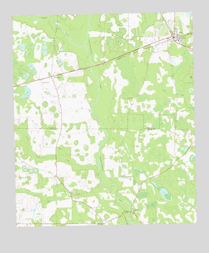
Leary, GA USGS Topographic Map
Click on map above to begin viewing in our Map Viewer.

This topographic map contains these locations and features:
Feature Name Type Latitude Longitude GNIS ID View Map
Bethel ChurchChurchN31.3946°W84.5866°311164View Map
Caney CreekStreamN31.4046°W84.5663°312306View Map
City of LearyCivilN31.4847°W84.5133°2404901View Map
Iveys MillPopulated PlaceN31.3913°W84.5860°332072View Map
LearyPopulated PlaceN31.4857°W84.5138°332194View Map
Leary Baptist ChurchChurchN31.4891°W84.5146°335067View Map
Leary City CemeteryCemeteryN31.4860°W84.5116°335068View Map
Leary Police DepartmentBuildingN31.4850°W84.5172°2733898View Map
Leary Volunteer Fire DepartmentBuildingN31.4869°W84.5130°2603956View Map
Macedonia ChurchChurchN31.3974°W84.5385°342840View Map
Macedonia ChurchChurchN31.4035°W84.5482°317527View Map
MilfordPopulated PlaceN31.3818°W84.5435°318157View Map
Milford Baptist ChurchChurchN31.3846°W84.5441°342841View Map
Milford ChurchChurchN31.3857°W84.5441°342842View Map
Mill CreekStreamN31.4002°W84.5660°318216View Map
Pachitla CreekStreamN31.4816°W84.5738°320149View Map
PatmosPopulated PlaceN31.3760°W84.5649°326455View Map
Patmos ChurchChurchN31.3763°W84.5655°342845View Map
Pine Bloom ChurchChurchN31.4499°W84.5452°320536View Map
Thompson LakeReservoirN31.3902°W84.6082°342137View Map
Thompson Lake DamDamN31.3902°W84.6082°342136View Map
WilliamsburgPopulated PlaceN31.4641°W84.5980°326593View Map
Williamsburg ChurchChurchN31.4605°W84.6044°325373View Map

Note: Coordinates in the location and feature list above are referenced to NAD83 datum.


Copyright (C) 2008-2025 Ryan Niemi / Sunset Dynamics ... All Rights Reserved