TopoQuest Logo
Do you find TopoQuest useful?
Help keep TopoQuest running and adding new maps/features by donating!
Bitcoin:  19c7KJd3qBynnjoSw5npx9KScwjBe4ifkT
Litecoin:  LXs6TkuXGGXo1vDsWCkWVdjQX94eUKd6ui
Home View Maps Find Maps Find Places Resources & Links


West Blocton East, Alabama Topographic Map

USGS Map Title: West Blocton East, AL
USGS Map MRC: 33087A1
DRG (GeoTIFF) Download: o33087a1.tif


Neighboring USGS Topographic Map Quads:


  Woodstock, AL  
33087B2
 

  Halfmile Shoals, AL  
33087B1
 

  Pea Ridge, AL  
33086B8
 

  West Blocton West, AL  
33087A2
 

  West Blocton East, AL  
33087A1
 

  Aldrich, AL  
33086A8
 

  Centreville West, AL  
32087H2
 

  Centreville East, AL  
32087H1
 

  Randolph, AL  
32086H8


Map MRC Location:

N34°
W88°
N34°
W87°
H8 H7 H6 H5 H4 H3 H2 H1
G8 G7 G6 G5 G4 G3 G2 G1
F8 F7 F6 F5 F4 F3 F2 F1
E8 E7 E6 E5 E4 E3 E2 E1
D8 D7 D6 D5 D4 D3 D2 D1
C8 C7 C6 C5 C4 C3 C2 C1
B8 B7 B6 B5 B4 B3 B2 B1
A8 A7 A6 A5 A4 A3 A2 A1
N33°
W88°
N33°
W87°

West Blocton East, AL USGS 1:24K Topographic Map Preview:
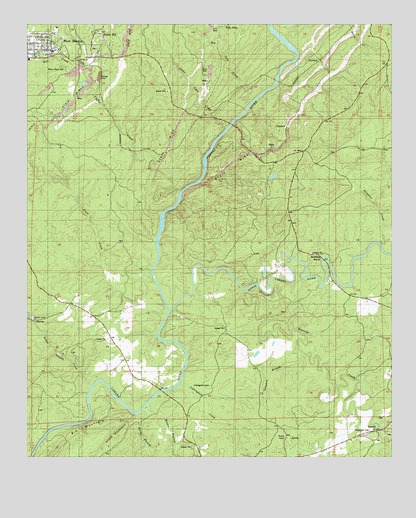
West Blocton East, AL USGS Topographic Map
Click on map above to begin viewing in our Map Viewer.

This topographic map contains these locations and features:
Feature Name Type Latitude Longitude GNIS ID View Map
Alligator CreekStreamN33.0615°W87.0033°113028View Map
Ardela (historical)Populated PlaceN33.1001°W87.0639°138351View Map
Belle EllenPopulated PlaceN33.1246°W87.0572°156046View Map
Big MountainSummitN33.0121°W87.0922°114298View Map
Big Ugly CreekStreamN33.1026°W87.0489°114335View Map
Blake FordCrossingN33.0404°W87.0769°138358View Map
Blocton (historical)Populated PlaceN33.1132°W87.1042°1959599View Map
Brown BranchStreamN33.0160°W87.0828°114981View Map
Bucktown (historical)Populated PlaceN33.1107°W87.1111°1959600View Map
Bulldog BendBendN33.0573°W87.0231°115188View Map
Cadle (historical)Populated PlaceN33.1037°W87.0555°138361View Map
Caffee CreekStreamN33.0771°W87.0728°155003View Map
Cahaba River National Wildlife RefugeParkN33.0748°W87.0644°2765223View Map
Cahaba Wildlife Management AreaParkN33.0251°W87.0003°138362View Map
ColeanorPopulated PlaceN33.0957°W87.0358°156200View Map
Confederate MineMineN33.1035°W87.0105°138367View Map
Corinne (historical)Populated PlaceN33.1132°W87.1075°1959604View Map
Cottingham CemeteryCemeteryN33.0209°W87.0622°116679View Map
Cottingham ChurchChurchN33.0212°W87.0617°149506View Map
Cottingham CreekStreamN33.0210°W87.0728°116680View Map
Desmans CampLocaleN33.0487°W87.0931°138368View Map
Elder School (historical)SchoolN33.0112°W87.0450°163226View Map
Flat TopPopulated PlaceN33.1237°W87.0992°1959608View Map
Gardner MineMineN33.0779°W87.0686°138372View Map
Hargrove (historical)Populated PlaceN33.0901°W87.0778°138375View Map
Hargrove ShoalsRapidsN33.0660°W87.0792°1959609View Map
Hawkinsville (historical)Populated PlaceN33.0746°W87.0353°1959610View Map
Hill CreekStreamN33.1148°W87.1064°120104View Map
Island FordCrossingN33.0573°W87.0239°1959612View Map
Italian Catholic CemeteryCemeteryN33.1129°W87.1133°1959613View Map
Italian TownPopulated PlaceN33.1185°W87.1000°150998View Map
Kimberly Clark Paper Company LakeReservoirN33.0811°W87.0405°131194View Map
Kimberly Clark Paper Company Lake DamDamN33.0801°W87.0417°131193View Map
Light FordCrossingN33.0535°W87.0814°166080View Map
Little Cahaba RiverStreamN33.0423°W87.0764°121726View Map
Little MountainSummitN33.0093°W87.0919°121818View Map
Little Schultz CreekStreamN33.0210°W87.1028°152114View Map
Little Ugly CreekStreamN33.0951°W87.0572°121899View Map
Nash Town (historical)Populated PlaceN33.1182°W87.0597°1959620View Map
New Hargrove (historical)Populated PlaceN33.0965°W87.0972°138388View Map
Pilgrim Rest (historical)Populated PlaceN33.0023°W87.0611°138390View Map
Pine Island CreekStreamN33.0785°W87.0680°168986View Map
Pine Island FordCrossingN33.0840°W87.0642°138392View Map
PiperPopulated PlaceN33.0896°W87.0414°156903View Map
Pratt CreekStreamN33.0529°W87.0822°125245View Map
Pratt Ferry (historical)CrossingN33.0187°W87.0750°138393View Map
Pratt Ferry BridgeBridgeN33.0190°W87.0789°138394View Map
Richs FordCrossingN33.1246°W87.0283°138395View Map
River Bend (historical)Populated PlaceN33.0298°W87.0903°138396View Map
Rock Institute (historical)SchoolN33.0468°W87.0044°138397View Map
Rocky BranchStreamN33.0135°W87.0853°125828View Map
Schultz Creek CemeteryCemeteryN33.0404°W87.1230°151001View Map
Schultz Creek Church SpringSpringN33.0393°W87.1219°1959623View Map
Schultz Creek Missionary Baptist ChurchChurchN33.0401°W87.1236°153348View Map
Serene Lake Number 7ReservoirN33.0285°W87.0317°131166View Map
Serene Lake Number 7 DamDamN33.0285°W87.0317°131167View Map
SeymourPopulated PlaceN33.1146°W87.0250°157042View Map
Shiney Rock CemeteryCemeteryN33.1126°W87.1119°126765View Map
Six Mile Presbyterian CemeteryCemeteryN33.0115°W87.0047°1959627View Map
SixmilePopulated PlaceN33.0079°W87.0055°153456View Map
Sixmile CreekStreamN33.0485°W87.0511°153457View Map
Sixmile Missionary Baptist ChurchChurchN33.0071°W87.0005°154174View Map
Sixmile SchoolSchoolN33.0051°W87.0044°155419View Map
Smith and Thomas Mill (historical)LocaleN33.0162°W87.0203°138402View Map
Smith HillPopulated PlaceN33.1223°W87.1019°127022View Map
Smith Hill Baptist ChurchChurchN33.1193°W87.0967°154170View Map
Stacks Hill (historical)Populated PlaceN33.1043°W87.0994°1959628View Map
Tanyard BranchStreamN33.0298°W87.0303°127674View Map
Thompson CemeteryCemeteryN33.0079°W87.0075°127893View Map
Tico (historical)LocaleN33.0932°W87.0700°138404View Map
Wesley Chapel CemeteryCemeteryN33.0067°W87.0367°2082903View Map
Wesley Chapel United Methodist ChurchChurchN33.0060°W87.0364°153930View Map
West BloctonPopulated PlaceN33.1182°W87.1250°153935View Map
West Blocton Fire DepartmentBuildingN33.1179°W87.1142°2682908View Map
West Blocton First Baptist ChurchChurchN33.1176°W87.1136°150997View Map
West Blocton Police DepartmentBuildingN33.1176°W87.1146°2751894View Map
West Blocton Post OfficePost OfficeN33.1167°W87.1165°168993View Map

Note: Coordinates in the location and feature list above are referenced to NAD83 datum.


Copyright (C) 2008-2024 Ryan Niemi / Sunset Dynamics ... All Rights Reserved