TopoQuest Logo
Do you find TopoQuest useful?
Help keep TopoQuest running and adding new maps/features by donating!
Bitcoin:  19c7KJd3qBynnjoSw5npx9KScwjBe4ifkT
Litecoin:  LXs6TkuXGGXo1vDsWCkWVdjQX94eUKd6ui
Home View Maps Find Maps Find Places Resources & Links


Pearl River, Mississippi Topographic Map

USGS Map Title: Pearl River, MS
USGS Map MRC: 32089G2
DRG (GeoTIFF) Download: o32089g2.tif


Neighboring USGS Topographic Map Quads:


  Four Corners, MS  
32089H3
 

  Plattsburg, MS  
32089H2
 

  Noxapater, MS  
32089H1
 

  Edinburg, MS  
32089G3
 

  Pearl River, MS  
32089G2
 

  Philadelphia, MS  
32089G1
 

  Madden, MS  
32089F3
 

  McDonald, MS  
32089F2
 

  Deemer, MS  
32089F1


Map MRC Location:

N33°
W90°
N33°
W89°
H8 H7 H6 H5 H4 H3 H2 H1
G8 G7 G6 G5 G4 G3 G2 G1
F8 F7 F6 F5 F4 F3 F2 F1
E8 E7 E6 E5 E4 E3 E2 E1
D8 D7 D6 D5 D4 D3 D2 D1
C8 C7 C6 C5 C4 C3 C2 C1
B8 B7 B6 B5 B4 B3 B2 B1
A8 A7 A6 A5 A4 A3 A2 A1
N32°
W90°
N32°
W89°

Pearl River, MS USGS 1:24K Topographic Map Preview:
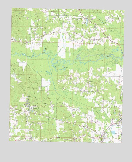
Pearl River, MS USGS Topographic Map
Click on map above to begin viewing in our Map Viewer.

This topographic map contains these locations and features:
Feature Name Type Latitude Longitude GNIS ID View Map
Beacon Street Baptist ChurchChurchN32.7718°W89.1267°685011View Map
Bear CreekStreamN32.8337°W89.2245°666642View Map
Black Jack CemeteryCemeteryN32.7926°W89.2303°707189View Map
Blackjack ChurchChurchN32.7921°W89.2303°667245View Map
Bogue KentawkaStreamN32.8307°W89.2084°685034View Map
Choctaw Central High SchoolSchoolN32.7818°W89.2253°668409View Map
Choctaw Fire Department Station 1 HeadquartersBuildingN32.7712°W89.1965°2665665View Map
Choctaw Fire Department Station 2BuildingN32.8067°W89.2414°2665794View Map
Choctaw Health CenterHospitalN32.7824°W89.2309°2672739View Map
Choctaw Indian Police DepartmentBuildingN32.7869°W89.2078°2754208View Map
Choctaw Youth CenterBuildingN32.7849°W89.2095°668415View Map
FairviewPopulated PlaceN32.7540°W89.1756°669877View Map
Fairview Volunteer Fire DepartmentBuildingN32.7542°W89.1762°2665835View Map
Funny Yockana CreekStreamN32.7560°W89.1351°685028View Map
Fusky (historical)LocaleN32.8685°W89.2012°707196View Map
Grover Willis Lake DamDamN32.8568°W89.1717°681703View Map
Henrys ChapelChurchN32.8068°W89.1626°671119View Map
Henrys Chapel CemeteryCemeteryN32.8071°W89.1626°707200View Map
Hills (historical)LocaleN32.8596°W89.2237°685030View Map
Jofuska CreekStreamN32.8279°W89.2042°666103View Map
Kentawka CanalCanalN32.7893°W89.1795°672107View Map
Little Kentawka CanalCanalN32.7907°W89.1584°672631View Map
McNeill CemeteryCemeteryN32.7687°W89.2303°707210View Map
Mississippi Choctaw ReservationCivilN32.7671°W89.2081°685014View Map
Mud LakeLakeN32.8358°W89.2118°674441View Map
Myers LakeLakeN32.8187°W89.1998°674495View Map
Neshoba County Sheriff's OfficeBuildingN32.7806°W89.1263°2754153View Map
New Pleasantdale Baptist ChurchChurchN32.7587°W89.1445°685042View Map
New Zion ChurchChurchN32.8101°W89.1715°674881View Map
Oak Grove CemeteryCemeteryN32.8401°W89.2367°707220View Map
Oak Grove ChurchChurchN32.8421°W89.2365°675044View Map
Old Pearl Valley CemeteryCemeteryN32.8654°W89.1801°1805861View Map
Old Pearl Valley ChurchChurchN32.8654°W89.1787°675222View Map
Pearl RiverPopulated PlaceN32.7835°W89.2278°675540View Map
Pearl River Census Designated PlaceCensusN32.7889°W89.2384°2403401View Map
Pearl Valley (historical)LocaleN32.8668°W89.1695°685046View Map
Pearl Valley CemeteryCemeteryN32.8676°W89.1712°707222View Map
Pearl Valley ChurchChurchN32.8668°W89.1712°675545View Map
Philadelphia Sewage Lagoon DamDamN32.7585°W89.1284°681628View Map
Supervisor District 1CivilN32.8064°W89.2245°711997View Map
Supervisor District 5CivilN32.8683°W89.1526°712001View Map
WHOC-AM (Philadelphia)TowerN32.7507°W89.1301°680121View Map
WilliamsvillePopulated PlaceN32.7590°W89.1437°679726View Map
Wolf CreekStreamN32.7943°W89.1945°679809View Map
Woodard CreekStreamN32.8271°W89.1328°679834View Map
WWSL-FM (Philadelphia)TowerN32.7674°W89.1301°680227View Map
Zaphyr HillPopulated PlaceN32.7749°W89.2431°685066View Map

Note: Coordinates in the location and feature list above are referenced to NAD83 datum.


Copyright (C) 2008-2024 Ryan Niemi / Sunset Dynamics ... All Rights Reserved