TopoQuest Logo
Do you find TopoQuest useful?
Help keep TopoQuest running and adding new maps/features by donating!
Bitcoin:  19c7KJd3qBynnjoSw5npx9KScwjBe4ifkT
Litecoin:  LXs6TkuXGGXo1vDsWCkWVdjQX94eUKd6ui
Home View Maps Find Maps Find Places Resources & Links


Four Corners, Mississippi Topographic Map

USGS Map Title: Four Corners, MS
USGS Map MRC: 32089H3
DRG (GeoTIFF) Download: o32089h3.tif


Neighboring USGS Topographic Map Quads:


  Ethel South, MS  
33089A4
 

  Ethel SE, MS  
33089A3
 

  Louisville SW, MS  
33089A2
 

  Zama, MS  
32089H4
 

  Four Corners, MS  
32089H3
 

  Plattsburg, MS  
32089H2
 

  Renfroe, MS  
32089G4
 

  Edinburg, MS  
32089G3
 

  Pearl River, MS  
32089G2


Map MRC Location:

N33°
W90°
N33°
W89°
H8 H7 H6 H5 H4 H3 H2 H1
G8 G7 G6 G5 G4 G3 G2 G1
F8 F7 F6 F5 F4 F3 F2 F1
E8 E7 E6 E5 E4 E3 E2 E1
D8 D7 D6 D5 D4 D3 D2 D1
C8 C7 C6 C5 C4 C3 C2 C1
B8 B7 B6 B5 B4 B3 B2 B1
A8 A7 A6 A5 A4 A3 A2 A1
N32°
W90°
N32°
W89°

Four Corners, MS USGS 1:24K Topographic Map Preview:
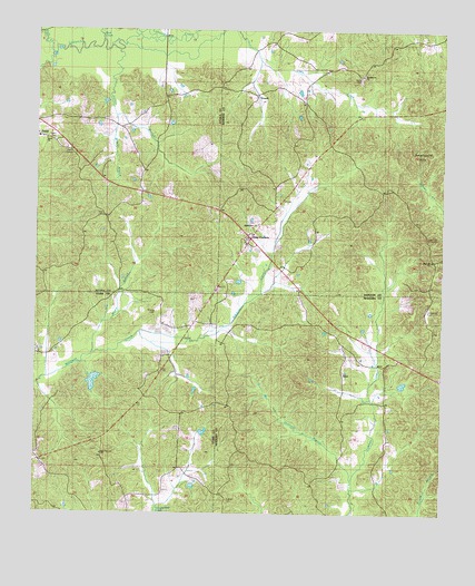
Four Corners, MS USGS Topographic Map
Click on map above to begin viewing in our Map Viewer.

This topographic map contains these locations and features:
Feature Name Type Latitude Longitude GNIS ID View Map
AlicePopulated PlaceN32.9110°W89.2801°691663View Map
Bear CreekStreamN32.9968°W89.3548°666644View Map
Bethlehem Church (historical)ChurchN32.9393°W89.3020°691129View Map
Ebenezer CemeteryCemeteryN32.8912°W89.3559°707085View Map
Ebenezer Church (historical)ChurchN32.8910°W89.3553°691141View Map
Four CornersLocaleN32.9462°W89.3090°670125View Map
Jennings BranchStreamN32.8840°W89.2770°671841View Map
Kea Chapel (historical)ChurchN32.8868°W89.2709°691147View Map
Kelley BranchStreamN32.9943°W89.3501°672080View Map
Kelley CemeteryCemeteryN32.9715°W89.3695°691107View Map
Kelly CemeteryCemeteryN32.9721°W89.3720°710905View Map
Kyle CreekStreamN32.9935°W89.3698°672223View Map
Mars Hill ChurchChurchN32.9404°W89.2531°673151View Map
Mars Hill Lookout TowerTowerN32.9460°W89.2542°711272View Map
Molpus Lumber Company Lake DamDamN32.9085°W89.3551°681735View Map
Mount Pleasant Church (historical)ChurchN32.9235°W89.3595°691156View Map
Myers BranchStreamN32.9162°W89.3565°674492View Map
New Ebenezer ChurchChurchN32.8904°W89.3545°691102View Map
Rattletrap CemeteryCemeteryN32.9279°W89.2542°676484View Map
Shields CemeteryCemeteryN32.9271°W89.3376°677663View Map
Smallwood CemeteryCemeteryN32.9879°W89.2756°710075View Map
Smallwood ChurchChurchN32.9882°W89.2765°677884View Map
Smallwood HillsSummitN32.9668°W89.2651°677885View Map
Sullivan CemeteryCemeteryN32.8787°W89.3153°678391View Map
VowellPopulated PlaceN32.9829°W89.3076°692297View Map
Wilkins BranchStreamN32.9779°W89.3503°679686View Map
Wood CemeteryCemeteryN32.9880°W89.2756°691109View Map
Zama Baptist ChurchChurchN32.9718°W89.3723°710186View Map
Zama ChurchChurchN32.9715°W89.3717°691108View Map

Note: Coordinates in the location and feature list above are referenced to NAD83 datum.


Copyright (C) 2008-2025 Ryan Niemi / Sunset Dynamics ... All Rights Reserved