TopoQuest Logo
Do you find TopoQuest useful?
Help keep TopoQuest running and adding new maps/features by donating!
Bitcoin:  19c7KJd3qBynnjoSw5npx9KScwjBe4ifkT
Litecoin:  LXs6TkuXGGXo1vDsWCkWVdjQX94eUKd6ui
Home View Maps Find Maps Find Places Resources & Links


Pennine, Tennessee Topographic Map

USGS Map Title: Pennine, TN
USGS Map MRC: 35084F8
DRG (GeoTIFF) Download: o35084f8.tif


Neighboring USGS Topographic Map Quads:


  Vandever, TN  
35085G1
 

  Grassy Cove, TN  
35084G8
 

  Roddy, TN  
35084G7
 

  Melvine, TN  
35085F1
 

  Pennine, TN  
35084F8
 

  Spring City, TN  
35084F7
 

  Morgan Springs, TN  
35085E1
 

  Evensville, TN  
35084E8
 

  Decatur, TN  
35084E7


Map MRC Location:

N36°
W85°
N36°
W84°
H8 H7 H6 H5 H4 H3 H2 H1
G8 G7 G6 G5 G4 G3 G2 G1
F8 F7 F6 F5 F4 F3 F2 F1
E8 E7 E6 E5 E4 E3 E2 E1
D8 D7 D6 D5 D4 D3 D2 D1
C8 C7 C6 C5 C4 C3 C2 C1
B8 B7 B6 B5 B4 B3 B2 B1
A8 A7 A6 A5 A4 A3 A2 A1
N35°
W85°
N35°
W84°

Pennine, TN USGS 1:24K Topographic Map Preview:
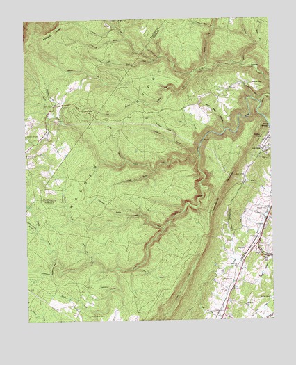
Pennine, TN USGS Topographic Map
Click on map above to begin viewing in our Map Viewer.

This topographic map contains these locations and features:
Feature Name Type Latitude Longitude GNIS ID View Map
Bearpen BranchStreamN35.6865°W84.9347°1305025View Map
BonhamPopulated PlaceN35.7206°W84.8963°1314715View Map
Bonham School (historical)SchoolN35.7212°W84.8952°1320189View Map
Bonneville (historical)Populated PlaceN35.6501°W84.9186°1311745View Map
Bumbee CreekStreamN35.6628°W84.9299°1278979View Map
Coalbank HollowValleyN35.7475°W84.9529°1280805View Map
Commissioner District 2CivilN35.6761°W84.9117°2463965View Map
Dead Negro HollowValleyN35.7042°W84.8982°1282252View Map
DeVaney CemeteryCemeteryN35.6412°W84.9002°1282246View Map
Dunlap CreekStreamN35.7292°W84.9072°1283193View Map
Duskin CreekStreamN35.6928°W84.9113°1283235View Map
Edgewood HillsPopulated PlaceN35.7045°W84.8755°1283527View Map
Edwards BranchStreamN35.7306°W84.8897°1283544View Map
Evans BranchStreamN35.7342°W84.9311°1283896View Map
Garrison Spring BranchStreamN35.6637°W84.9955°1285217View Map
Georgia BranchStreamN35.7465°W84.9530°1285312View Map
Hickory Grove CemeteryCemeteryN35.6267°W84.9683°1287584View Map
Hickory Grove School (historical)SchoolN35.6265°W84.9672°1320220View Map
Horseshoe BendBendN35.6478°W84.9877°1288429View Map
Ideal ValleyPopulated PlaceN35.6962°W84.8794°1288902View Map
Ivy BranchStreamN35.7098°W84.9877°1289121View Map
Kirkwood Number One MineMineN35.6715°W84.9422°1320224View Map
Little Rockhouse BranchStreamN35.6992°W84.9244°1291650View Map
Little Rocky BranchStreamN35.7390°W84.8813°1291653View Map
Little Soak CreekStreamN35.7273°W84.9141°1291668View Map
Long BranchStreamN35.7165°W84.9427°1291873View Map
Luminary School (historical)SchoolN35.6937°W84.9991°1318025View Map
Maple BranchStreamN35.6284°W84.9655°1292612View Map
Mapleslush BranchStreamN35.6681°W84.9475°1292644View Map
McCabe SpringSpringN35.6342°W84.8763°1293093View Map
Miller CemeteryCemeteryN35.6542°W84.8927°1293919View Map
MiloPopulated PlaceN35.6962°W84.9991°1311065View Map
Moccasin CreekStreamN35.6462°W84.9558°1269811View Map
Mountain View Church (historical)ChurchN35.6903°W84.9983°1318031View Map
Newby BranchStreamN35.6915°W84.9486°1295682View Map
Norris Number One MineMineN35.6717°W84.9483°1320239View Map
PenninePopulated PlaceN35.6367°W84.8961°1297149View Map
Pennine Baptist ChurchChurchN35.6370°W84.8958°1320245View Map
Pennine Post Office (historical)Post OfficeN35.6370°W84.8958°1651393View Map
Pine BranchStreamN35.6470°W84.9450°1297515View Map
Pine BranchStreamN35.6998°W84.9094°1297517View Map
Piney CreekStreamN35.6928°W84.9111°1297625View Map
Pleasant Hill CemeteryCemeteryN35.7020°W84.9994°1297853View Map
Rector MineMineN35.6948°W84.8880°1320250View Map
Rockhouse BranchStreamN35.6942°W84.9116°1299814View Map
Rocky Creek Number Six MineMineN35.6826°W84.9372°1320261View Map
Rowe SpringSpringN35.6389°W84.9630°1300202View Map
Schoolhouse HollowValleyN35.6589°W84.8954°1300895View Map
Seven SpringSpringN35.6849°W84.8886°1301101View Map
Sheffield ChurchChurchN35.6381°W84.8952°1320265View Map
Shingle Mill BranchStreamN35.7459°W84.9033°1270105View Map
Shut in GapGapN35.7226°W84.8838°1270240View Map
Soak CreekStreamN35.7148°W84.8791°1303710View Map
Sow HollowValleyN35.6263°W84.9042°1270927View Map
Spears CemeteryCemeteryN35.6284°W84.9052°1270966View Map
Spring City Memory GardensCemeteryN35.6626°W84.8777°1271061View Map
Stinging ForkStreamN35.7276°W84.9141°1303845View Map
Stinging Fork FallsFallsN35.7211°W84.9271°1271444View Map
Sweeny BranchStreamN35.7420°W84.9488°1303967View Map
Thurman CemeteryCemeteryN35.7217°W84.9519°1272600View Map
Thurman Spring BranchStreamN35.7106°W84.9855°1272608View Map
Turkey Cock BranchStreamN35.6506°W84.9666°1272995View Map
Walden RidgeRidgeN35.6987°W84.9577°1304325View Map
Walden RidgeLocaleN35.7117°W84.9686°1273550View Map
Wassom CemeteryCemeteryN35.6706°W84.8777°1273870View Map
Webbs ChapelChurchN35.7142°W84.9855°1274044View Map
Webbs Chapel School (historical)SchoolN35.7142°W84.9855°1318061View Map
Whiteoak BottomsBendN35.7301°W84.8841°1274424View Map
Winnie CemeteryCemeteryN35.6892°W84.9986°1274882View Map
WXQK-AM (Spring City)TowerN35.6665°W84.8788°1639881View Map
WXQK-AM (Spring City)TowerN35.6723°W84.8816°1639883View Map
Youngs CreekStreamN35.6498°W84.9872°1304715View Map

Note: Coordinates in the location and feature list above are referenced to NAD83 datum.


Copyright (C) 2008-2025 Ryan Niemi / Sunset Dynamics ... All Rights Reserved