TopoQuest Logo
Do you find TopoQuest useful?
Help keep TopoQuest running and adding new maps/features by donating!
Bitcoin:  19c7KJd3qBynnjoSw5npx9KScwjBe4ifkT
Litecoin:  LXs6TkuXGGXo1vDsWCkWVdjQX94eUKd6ui
Home View Maps Find Maps Find Places Resources & Links


Vandever, Tennessee Topographic Map

USGS Map Title: Vandever, TN
USGS Map MRC: 35085G1
DRG (GeoTIFF) Download: o35085g1.tif


Neighboring USGS Topographic Map Quads:


  Pleasant Hill, TN  
35085H2
 

  Crossville, TN  
35085H1
 

  Dorton, TN  
35084H8
 

  Herbert Domain, TN  
35085G2
 

  Vandever, TN  
35085G1
 

  Grassy Cove, TN  
35084G8
 

  Billingsley Gap, TN  
35085F2
 

  Melvine, TN  
35085F1
 

  Pennine, TN  
35084F8


Map MRC Location:

N36°
W86°
N36°
W85°
H8 H7 H6 H5 H4 H3 H2 H1
G8 G7 G6 G5 G4 G3 G2 G1
F8 F7 F6 F5 F4 F3 F2 F1
E8 E7 E6 E5 E4 E3 E2 E1
D8 D7 D6 D5 D4 D3 D2 D1
C8 C7 C6 C5 C4 C3 C2 C1
B8 B7 B6 B5 B4 B3 B2 B1
A8 A7 A6 A5 A4 A3 A2 A1
N35°
W86°
N35°
W85°

Vandever, TN USGS 1:24K Topographic Map Preview:
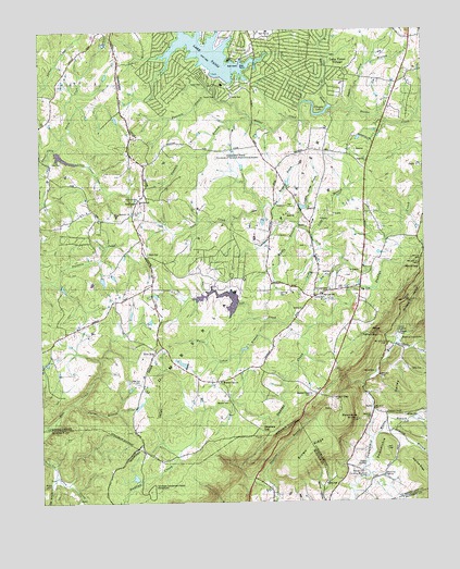
Vandever, TN USGS Topographic Map
Click on map above to begin viewing in our Map Viewer.

This topographic map contains these locations and features:
Feature Name Type Latitude Longitude GNIS ID View Map
Apple Orchard BranchStreamN35.8548°W85.0222°1275822View Map
Bennett CemeteryCemeteryN35.8170°W85.0377°1318282View Map
Big BranchStreamN35.7576°W85.1205°1277256View Map
Big LickPopulated PlaceN35.8073°W85.0213°1314679View Map
Big Lick CemeteryCemeteryN35.8098°W85.0258°1318283View Map
Big Lick SchoolSchoolN35.8051°W85.0330°1277341View Map
Blalock KnobSummitN35.7720°W85.0275°1305284View Map
Brown GapGapN35.7770°W85.0300°1305449View Map
Brown RidgeRidgeN35.7628°W85.0391°1278600View Map
BurkePopulated PlaceN35.7745°W85.0169°1314774View Map
Burnt Cabin BranchStreamN35.7981°W85.0500°1305554View Map
Calvary ChurchChurchN35.8045°W85.0355°1305606View Map
Carding Machine SpringSpringN35.7571°W85.0195°1279662View Map
Commissioner District 5CivilN35.8418°W85.1031°2464434View Map
Cottrell BranchStreamN35.8523°W85.0561°1306133View Map
Cumberland County Fire Department Station 5BuildingN35.8701°W85.0540°2654949View Map
Cumberland County Fire Department Station 5 - 2BuildingN35.8062°W85.0327°2654762View Map
Davis CemeteryCemeteryN35.8159°W85.0900°1282146View Map
Devilstep HollowValleyN35.7912°W85.0097°1282407View Map
Flatrock BranchStreamN35.8603°W85.0675°1284437View Map
Grassland FarmSchoolN35.8426°W85.0594°1285873View Map
Gravelly SpurValleyN35.7904°W85.0038°1285945View Map
Hale CemeteryCemeteryN35.8403°W85.1213°1286518View Map
Hale ChapelChurchN35.8298°W85.0930°1286520View Map
Hale Chapel CemeteryCemeteryN35.8287°W85.0922°1318274View Map
Hales Chapel School (historical)SchoolN35.8303°W85.0930°1318273View Map
Hall CemeteryCemeteryN35.7642°W85.0127°1286566View Map
Head of SequatchieSpringN35.7928°W85.0076°1287276View Map
HellholeBasinN35.7953°W85.0172°1287340View Map
Hillcrest CemeteryCemeteryN35.8065°W85.0308°1287820View Map
Hilltop AcresPopulated PlaceN35.7687°W85.0958°1302869View Map
Hinch CemeteryCemeteryN35.7845°W85.0163°1287861View Map
Hinch Mill (historical)LocaleN35.7912°W85.0075°1302870View Map
Hog Heaven BranchStreamN35.8278°W85.0483°1287980View Map
Houston CemeteryCemeteryN35.8065°W85.0283°1318285View Map
Kerley CemeteryCemeteryN35.7553°W85.0322°1290096View Map
Kiowa SubdivisionPopulated PlaceN35.8598°W85.0833°1302892View Map
Lake TansiPopulated PlaceN35.8728°W85.0544°1852675View Map
Lake TansiReservoirN35.8692°W85.0699°1304001View Map
Lake Tansi Census Designated PlaceCensusN35.8706°W85.0617°2403206View Map
Lantana Division (historical)CensusN35.8145°W85.1033°1648667View Map
Lick CreekStreamN35.8070°W85.0166°1291203View Map
Long BranchStreamN35.8206°W85.0358°1291876View Map
Manning SpringSpringN35.7565°W85.0137°1292589View Map
Melvin Smith LakeReservoirN35.7867°W85.0789°1302133View Map
Melvin Smith Lake DamDamN35.7867°W85.0783°1302134View Map
Morris GapGapN35.8117°W85.0013°1294429View Map
Muddy BranchStreamN35.8231°W85.0402°1295025View Map
Music (historical)Populated PlaceN35.7765°W85.0633°1302905View Map
Musick CemeteryCemeteryN35.7765°W85.0638°1295168View Map
New EraPopulated PlaceN35.7895°W85.0877°1315585View Map
New Era CemeteryCemeteryN35.7817°W85.0930°1295475View Map
New Era School (historical)SchoolN35.7890°W85.0877°1302920View Map
Nicholson HeightsPopulated PlaceN35.8292°W85.0888°1302919View Map
Oak GrovePopulated PlaceN35.8042°W85.0361°1302930View Map
Oak Grove Church (historical)ChurchN35.7953°W85.0263°1302929View Map
Ojibwa SubdivisionPopulated PlaceN35.8626°W85.0402°1302927View Map
Oneida SubdivisionPopulated PlaceN35.8723°W85.0855°1302928View Map
Ormes CemeteryCemeteryN35.7662°W85.0302°1318287View Map
ParhamPopulated PlaceN35.7731°W85.0125°1302934View Map
Parham CemeteryCemeteryN35.7584°W85.0236°1296766View Map
Parham ChapelChurchN35.7734°W85.0127°1296769View Map
Parham GapGapN35.7848°W85.0291°1302933View Map
Pee Dee RidgeRidgeN35.7590°W85.0027°1297106View Map
Perry CemeteryCemeteryN35.8326°W85.0894°1318275View Map
Perry CreekStreamN35.8437°W85.1200°1297212View Map
Pleasant View EstatesPopulated PlaceN35.8606°W85.0130°1302932View Map
Pugh CemeteryCemeteryN35.8084°W85.0161°1318284View Map
Roaring BranchStreamN35.7678°W85.0155°1299562View Map
Rockpile Church (historical)ChurchN35.7606°W85.0097°1302948View Map
Salton CreekStreamN35.7576°W85.1205°1300599View Map
Selby CemeteryCemeteryN35.7848°W85.0008°1301040View Map
Selby CreekStreamN35.7917°W85.0088°1301041View Map
Seminole SubdivisionPopulated PlaceN35.8562°W85.0777°1302953View Map
Stacy SpringSpringN35.7603°W85.0197°1271185View Map
Stephens GapGapN35.7690°W85.0533°1303825View Map
Stephens Gap ChurchChurchN35.7820°W85.0672°1271338View Map
Sulphur Spring BranchStreamN35.8237°W85.0405°1271803View Map
Tansi Lake DamDamN35.8628°W85.0661°1307162View Map
Tansi ResortLocaleN35.8681°W85.0575°1272092View Map
Van Hoy CemeteryCemeteryN35.8053°W85.0472°1304293View Map
VandeverPopulated PlaceN35.8309°W85.0919°1314452View Map
Vandever Baptist ChurchChurchN35.8234°W85.0958°1318271View Map
Webb Chapel School (historical)SchoolN35.7762°W85.0561°1302971View Map
Webbs Chapel (historical)ChurchN35.7767°W85.0555°1318270View Map
Wilson BranchStreamN35.7665°W85.0172°1274796View Map
Wilson CemeteryCemeteryN35.7726°W85.0066°1274807View Map
Wilson Pen BranchStreamN35.8545°W85.0297°1274842View Map
Winnebago SubdivisionPopulated PlaceN35.8612°W85.0513°1302969View Map
Wyatt (historical)Populated PlaceN35.8348°W85.0908°1302970View Map

Note: Coordinates in the location and feature list above are referenced to NAD83 datum.


Copyright (C) 2008-2025 Ryan Niemi / Sunset Dynamics ... All Rights Reserved