TopoQuest Logo
Do you find TopoQuest useful?
Help keep TopoQuest running and adding new maps/features by donating!
Bitcoin:  19c7KJd3qBynnjoSw5npx9KScwjBe4ifkT
Litecoin:  LXs6TkuXGGXo1vDsWCkWVdjQX94eUKd6ui
Home View Maps Find Maps Find Places Resources & Links


Birdsville, Georgia Topographic Map

USGS Map Title: Birdsville, GA
USGS Map MRC: 32082G1
DRG (GeoTIFF) Download: o32082g1.tif


Neighboring USGS Topographic Map Quads:


  Scotts Corner, GA  
32082H2
 

  Bellevue, GA  
32082H1
 

  Perkins, GA  
32081H8
 

  Midville, GA  
32082G2
 

  Birdsville, GA  
32082G1
 

  Millen, GA  
32081G8
 

  Canoochee, GA  
32082F2
 

  Garfield, GA  
32082F1
 

  Four Points, GA  
32081F8


Map MRC Location:

N33°
W83°
N33°
W82°
H8 H7 H6 H5 H4 H3 H2 H1
G8 G7 G6 G5 G4 G3 G2 G1
F8 F7 F6 F5 F4 F3 F2 F1
E8 E7 E6 E5 E4 E3 E2 E1
D8 D7 D6 D5 D4 D3 D2 D1
C8 C7 C6 C5 C4 C3 C2 C1
B8 B7 B6 B5 B4 B3 B2 B1
A8 A7 A6 A5 A4 A3 A2 A1
N32°
W83°
N32°
W82°

Birdsville, GA USGS 1:24K Topographic Map Preview:
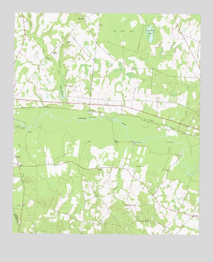
Birdsville, GA USGS Topographic Map
Click on map above to begin viewing in our Map Viewer.

This topographic map contains these locations and features:
Feature Name Type Latitude Longitude GNIS ID View Map
Anderson CemeteryCemeteryN32.8438°W82.0459°310520View Map
Anderson Chapel (historical)ChurchN32.8285°W82.0140°342971View Map
Bennetts LandingPopulated PlaceN32.8021°W82.0435°326180View Map
Big Dukes PondLakeN32.8638°W82.0512°311381View Map
Big SinkFlatN32.7896°W82.0404°311410View Map
BirdsvillePopulated PlaceN32.8715°W82.0779°354739View Map
Birdsville Airport (historical)AirportN32.8685°W82.0687°342974View Map
Blue SpringsSpringN32.8024°W82.0568°311559View Map
Brinson LakeReservoirN32.8556°W82.1054°341653View Map
Brinson Lake DamDamN32.8518°W82.1032°341652View Map
Buckhead AcademySchoolN32.8527°W82.0990°311977View Map
Bull Hole LandingLocaleN32.8102°W82.1196°331278View Map
Chew Mill CreekStreamN32.8152°W82.0896°312631View Map
Chew MillpondReservoirN32.8315°W82.0926°355144View Map
Chew Millpond DamDamN32.8315°W82.0926°341650View Map
Crooked BranchStreamN32.8038°W82.0471°313128View Map
Cushingville (historical)Populated PlaceN32.8079°W82.0096°342976View Map
Cypress CreekStreamN32.8138°W82.0801°313244View Map
Deep CreekStreamN32.8090°W82.1165°313411View Map
Deep Creek ChurchChurchN32.7893°W82.1215°313416View Map
Drakes ChapelChurchN32.7929°W82.1226°355547View Map
Dry BranchStreamN32.8021°W82.0112°313640View Map
Fountain Springs ChurchChurchN32.7668°W82.0471°314314View Map
Jones TempleChurchN32.7663°W82.1179°316259View Map
Kents LandingLocaleN32.8029°W82.0179°332141View Map
Lane LandingLocaleN32.7946°W82.0121°332182View Map
Law CemeteryCemeteryN32.8727°W82.1198°316688View Map
Little Dukes PondLakeN32.8649°W82.0332°317061View Map
Ogeechee ChurchChurchN32.7871°W82.0665°319916View Map
Pew LandingLocaleN32.8082°W82.1146°332649View Map
RogersPopulated PlaceN32.8193°W82.0737°332911View Map
Rogers CrossingCrossingN32.8157°W82.0735°332912View Map
Rosemary ChurchChurchN32.7579°W82.0359°321930View Map
Springhead CreekStreamN32.8418°W82.0937°323474View Map
The CanalStreamN32.8615°W82.1121°324039View Map
Wiggens CemeteryCemeteryN32.7727°W82.0684°325256View Map
Williams Grove CemeteryCemeteryN32.8338°W82.0851°325355View Map
Williams Grove Church (historical)ChurchN32.8321°W82.0854°343010View Map

Note: Coordinates in the location and feature list above are referenced to NAD83 datum.


Copyright (C) 2008-2024 Ryan Niemi / Sunset Dynamics ... All Rights Reserved