TopoQuest Logo
Do you find TopoQuest useful?
Help keep TopoQuest running and adding new maps/features by donating!
Bitcoin:  19c7KJd3qBynnjoSw5npx9KScwjBe4ifkT
Litecoin:  LXs6TkuXGGXo1vDsWCkWVdjQX94eUKd6ui
Home View Maps Find Maps Find Places Resources & Links


Perry NE, Missouri Topographic Map

USGS Map Title: Perry NE, MO
USGS Map MRC: 39091D5
DRG (GeoTIFF) Download: o39091d5.tif


Neighboring USGS Topographic Map Quads:


  Clarence Cannon Dam, MO  
39091E6
 

  Center, MO  
39091E5
 

  New London, MO  
39091E4
 

  Perry, MO  
39091D6
 

  Perry NE, MO  
39091D5
 

  Spencerburg, MO  
39091D4
 

  Hutchison, MO  
39091C6
 

  Farber, MO  
39091C5
 

  Vandalia, MO  
39091C4


Map MRC Location:

N40°
W92°
N40°
W91°
H8 H7 H6 H5 H4 H3 H2 H1
G8 G7 G6 G5 G4 G3 G2 G1
F8 F7 F6 F5 F4 F3 F2 F1
E8 E7 E6 E5 E4 E3 E2 E1
D8 D7 D6 D5 D4 D3 D2 D1
C8 C7 C6 C5 C4 C3 C2 C1
B8 B7 B6 B5 B4 B3 B2 B1
A8 A7 A6 A5 A4 A3 A2 A1
N39°
W92°
N39°
W91°

Perry NE, MO USGS 1:24K Topographic Map Preview:
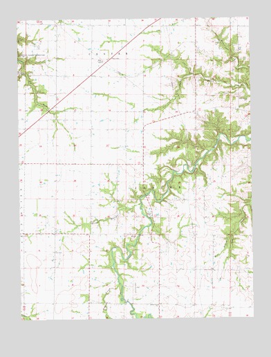
Perry NE, MO USGS Topographic Map
Click on map above to begin viewing in our Map Viewer.

This topographic map contains these locations and features:
Feature Name Type Latitude Longitude GNIS ID View Map
Barron Aviation AirportAirportN39.4011°W91.5869°2679377View Map
Bear BranchStreamN39.3900°W91.5724°713778View Map
Beaver Dam Presbyterian Church (historical)ChurchN39.4106°W91.6054°744121View Map
Butler School (historical)SchoolN39.3887°W91.5410°743928View Map
Cross Lanes School (historical)SchoolN39.4243°W91.5261°743927View Map
Fern ChapelChurchN39.4031°W91.6071°729485View Map
Frazier School (historical)SchoolN39.4977°W91.5674°744074View Map
Hays BranchStreamN39.4089°W91.5115°719265View Map
Hays CreekStreamN39.4245°W91.5002°719267View Map
Jessamine (historical)LocaleN39.3945°W91.5099°744082View Map
Lone Prairie School (historical)SchoolN39.3820°W91.5974°743930View Map
Madisonville CemeteryCemeteryN39.4664°W91.5013°721748View Map
Noonan (historical)LocaleN39.4600°W91.6113°743925View Map
Oakdale School (historical)SchoolN39.4646°W91.5580°743926View Map
Orwood (historical)LocaleN39.4675°W91.6010°743924View Map
Perry Rural Fire Protection AssociationBuildingN39.4777°W91.6178°2621493View Map
Spencer Creek ChurchChurchN39.3806°W91.5515°729398View Map
Straight BranchStreamN39.4231°W91.5596°727169View Map
Swell Head School (historical)SchoolN39.4909°W91.5288°744114View Map
Township of JasperCivilN39.4018°W91.5275°767251View Map
Union ChapelChurchN39.4175°W91.5549°727977View Map
West HartfordPopulated PlaceN39.4106°W91.6054°740519View Map
West Hartford School (historical)SchoolN39.4112°W91.5968°743929View Map

Note: Coordinates in the location and feature list above are referenced to NAD83 datum.


Copyright (C) 2008-2024 Ryan Niemi / Sunset Dynamics ... All Rights Reserved