TopoQuest Logo
Do you find TopoQuest useful?
Help keep TopoQuest running and adding new maps/features by donating!
Bitcoin:  19c7KJd3qBynnjoSw5npx9KScwjBe4ifkT
Litecoin:  LXs6TkuXGGXo1vDsWCkWVdjQX94eUKd6ui
Home View Maps Find Maps Find Places Resources & Links


Perry, Missouri Topographic Map

USGS Map Title: Perry, MO
USGS Map MRC: 39091D6
DRG (GeoTIFF) Download: o39091d6.tif


Neighboring USGS Topographic Map Quads:


  Stoutsville, MO  
39091E7
 

  Clarence Cannon Dam, MO  
39091E6
 

  Center, MO  
39091E5
 

  Florida, MO  
39091D7
 

  Perry, MO  
39091D6
 

  Perry NE, MO  
39091D5
 

  Santa Fe, MO  
39091C7
 

  Hutchison, MO  
39091C6
 

  Farber, MO  
39091C5


Map MRC Location:

N40°
W92°
N40°
W91°
H8 H7 H6 H5 H4 H3 H2 H1
G8 G7 G6 G5 G4 G3 G2 G1
F8 F7 F6 F5 F4 F3 F2 F1
E8 E7 E6 E5 E4 E3 E2 E1
D8 D7 D6 D5 D4 D3 D2 D1
C8 C7 C6 C5 C4 C3 C2 C1
B8 B7 B6 B5 B4 B3 B2 B1
A8 A7 A6 A5 A4 A3 A2 A1
N39°
W92°
N39°
W91°

Perry, MO USGS 1:24K Topographic Map Preview:
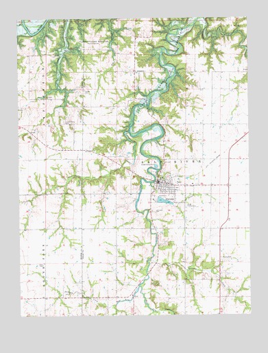
Perry, MO USGS Topographic Map
Click on map above to begin viewing in our Map Viewer.

This topographic map contains these locations and features:
Feature Name Type Latitude Longitude GNIS ID View Map
Ashbury Lake DamDamN39.3834°W91.7102°765250View Map
Burbridge CreekStreamN39.4525°W91.6899°715061View Map
City LakesReservoirN39.4239°W91.6746°715856View Map
City of PerryCivilN39.4300°W91.6665°2396184View Map
East Lick CreekStreamN39.3873°W91.6849°717319View Map
Fagan School (historical)SchoolN39.3866°W91.6982°743919View Map
Gallaher CreekStreamN39.3987°W91.6793°718317View Map
Gatson School (historical)SchoolN39.4773°W91.6438°743918View Map
GreenlawnPopulated PlaceN39.4775°W91.6863°740884View Map
Greenlawn CemeteryCemeteryN39.4778°W91.6861°2127676View Map
Greenlawn Methodist ChurchChurchN39.4775°W91.6861°2127675View Map
Heavenridge School (historical)SchoolN39.4850°W91.7436°743921View Map
Irvine School (historical)SchoolN39.4550°W91.6571°743969View Map
Jim Gough Airport (historical)AirportN39.4209°W91.6585°758855View Map
Lick CreekStreamN39.4515°W91.6853°721030View Map
Lick Creek CemeteryCemeteryN39.4186°W91.6777°721032View Map
Mace BranchStreamN39.4309°W91.6785°729334View Map
Mount Prairie ChurchChurchN39.4667°W91.7354°729350View Map
Muldrow CemeteryCemeteryN39.3992°W91.6410°723052View Map
Muldrow School (historical)SchoolN39.3900°W91.6511°743920View Map
Number 571 DamDamN39.4534°W91.6968°761491View Map
Old Mount Prairie CemeteryCemeteryN39.4559°W91.7243°723768View Map
PerryPopulated PlaceN39.4312°W91.6752°724232View Map
Perry City Dam - LowerDamN39.4234°W91.6752°761303View Map
Perry City Dam Number 2DamN39.4228°W91.6707°761627View Map
Perry City LakeReservoirN39.4233°W91.6732°761304View Map
Perry City Lake UpperReservoirN39.4223°W91.6688°761628View Map
Perry Elementary School (historical)SchoolN39.4325°W91.6723°2650213View Map
Perry Police DepartmentBuildingN39.4313°W91.6742°2752357View Map
Perry Post OfficePost OfficeN39.4308°W91.6735°2782978View Map
Perry Volunteer Fire DepartmentBuildingN39.4316°W91.6739°2621574View Map
Pigeon Roost CreekStreamN39.4706°W91.7276°724333View Map
Purdey CreekStreamN39.3795°W91.6982°725005View Map
Robert E Allen Recreation AreaParkN39.4914°W91.7296°736217View Map
Scobee CemeteryCemeteryN39.4689°W91.7138°726133View Map
Tillett School (historical)SchoolN39.3890°W91.7363°743923View Map
Township of Salt RiverCivilN39.4250°W91.6686°767253View Map
West Lick CreekStreamN39.3870°W91.6854°728597View Map
Wolf CemeteryCemeteryN39.4392°W91.6715°729035View Map
Wommack School (historical)SchoolN39.4408°W91.7207°743922View Map
Wood Acres AirportAirportN39.4739°W91.7090°758856View Map
Wood Acres DamDamN39.4717°W91.7152°765251View Map

Note: Coordinates in the location and feature list above are referenced to NAD83 datum.


Copyright (C) 2008-2025 Ryan Niemi / Sunset Dynamics ... All Rights Reserved