TopoQuest Logo
Do you find TopoQuest useful?
Help keep TopoQuest running and adding new maps/features by donating!
Bitcoin:  19c7KJd3qBynnjoSw5npx9KScwjBe4ifkT
Litecoin:  LXs6TkuXGGXo1vDsWCkWVdjQX94eUKd6ui
Home View Maps Find Maps Find Places Resources & Links


Petrey, Alabama Topographic Map

USGS Map Title: Petrey, AL
USGS Map MRC: 31086G2
DRG (GeoTIFF) Download: o31086g2.tif


Neighboring USGS Topographic Map Quads:


  Lapine, AL  
31086H3
 

  Grady, AL  
31086H2
 

  Ansley, AL  
31086H1
 

  Fullers Crossroads, AL  
31086G3
 

  Petrey, AL  
31086G2
 

  Youngblood, AL  
31086G1
 

  Luverne, AL  
31086F3
 

  Glenwood, AL  
31086F2
 

  Goshen, AL  
31086F1


Map MRC Location:

N32°
W87°
N32°
W86°
H8 H7 H6 H5 H4 H3 H2 H1
G8 G7 G6 G5 G4 G3 G2 G1
F8 F7 F6 F5 F4 F3 F2 F1
E8 E7 E6 E5 E4 E3 E2 E1
D8 D7 D6 D5 D4 D3 D2 D1
C8 C7 C6 C5 C4 C3 C2 C1
B8 B7 B6 B5 B4 B3 B2 B1
A8 A7 A6 A5 A4 A3 A2 A1
N31°
W87°
N31°
W86°

Petrey, AL USGS 1:24K Topographic Map Preview:
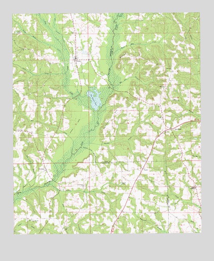
Petrey, AL USGS Topographic Map
Click on map above to begin viewing in our Map Viewer.

This topographic map contains these locations and features:
Feature Name Type Latitude Longitude GNIS ID View Map
Bear CreekStreamN31.7752°W86.2205°113658View Map
Bee CreekStreamN31.7960°W86.2111°113799View Map
Blue CreekStreamN31.8113°W86.1955°114534View Map
Blue Creek Post Office (historical)Post OfficeN31.8427°W86.1575°139828View Map
Buffs Store (historical)LocaleN31.7663°W86.1538°133904View Map
Byrds PondReservoirN31.7786°W86.1779°115347View Map
Camp Ground ChurchChurchN31.7777°W86.2036°115463View Map
Chapel Hill CemeteryCemeteryN31.8329°W86.1480°139835View Map
County Line BranchStreamN31.7990°W86.2055°116714View Map
Darien ChurchChurchN31.7524°W86.2163°117074View Map
DavisLocaleN31.7802°W86.1686°133916View Map
Dry CreekStreamN31.8546°W86.2138°117558View Map
Dyers Bridge (historical)BridgeN31.8710°W86.1816°139846View Map
Gin BranchStreamN31.7749°W86.2397°118976View Map
Green Store (historical)LocaleN31.8557°W86.2408°133925View Map
Head CemeteryCemeteryN31.8532°W86.1652°163532View Map
Indian LakeReservoirN31.8646°W86.2475°120664View Map
JoquinPopulated PlaceN31.7865°W86.1641°121035View Map
Joquin ChurchChurchN31.7804°W86.1666°133936View Map
Joquin School (historical)SchoolN31.7807°W86.1647°133937View Map
Live OakPopulated PlaceN31.8085°W86.2475°156620View Map
Macedonia CemeteryCemeteryN31.8424°W86.1447°1730469View Map
Macedonia ChurchChurchN31.8429°W86.1441°122150View Map
Mitchell Store (historical)LocaleN31.7882°W86.1627°133946View Map
Motes HillSummitN31.8510°W86.1747°123125View Map
Motes Mill CreekStreamN31.8510°W86.1841°123127View Map
Mount Zion Missionary Baptist ChurchChurchN31.8335°W86.1483°139836View Map
New Harmony ChurchChurchN31.7577°W86.2377°123753View Map
Nichols Store (historical)LocaleN31.7543°W86.2166°133952View Map
Northeast Crensahw Volunteer Fire DepartmentBuildingN31.8498°W86.2068°2691470View Map
Oak Bluff School (historical)SchoolN31.8335°W86.1486°139895View Map
Old Gin BranchStreamN31.8324°W86.1830°124210View Map
Olustee CreekStreamN31.8740°W86.1794°152811View Map
Panther CreekStreamN31.8007°W86.2038°124410View Map
Panther HillSummitN31.8146°W86.1855°124422View Map
PatsburgPopulated PlaceN31.7865°W86.2283°124485View Map
Patsburg ChurchChurchN31.7877°W86.2294°133958View Map
Patsburg Post Office (historical)Post OfficeN31.7863°W86.2277°168354View Map
PetreyPopulated PlaceN31.8488°W86.2077°124652View Map
Petrey CemeteryCemeteryN31.8640°W86.2086°124653View Map
Piney Woods CreekStreamN31.8410°W86.2147°152947View Map
Poley CreekStreamN31.8410°W86.2147°125101View Map
Rockwell ChurchChurchN31.8071°W86.1494°153194View Map
Rural HomeLocaleN31.8090°W86.1450°126018View Map
Slaughter Mill (historical)LocaleN31.8404°W86.2269°133975View Map
Stephens CemeteryCemeteryN31.8193°W86.1694°163570View Map
Tank ChurchChurchN31.8268°W86.2116°127660View Map
The Beaver PondLakeN31.8263°W86.1953°127795View Map
Thomas CrossroadPopulated PlaceN31.7765°W86.1286°127866View Map
Town of PetreyCivilN31.8495°W86.2057°2407104View Map
Turkey CreekStreamN31.7779°W86.2269°153736View Map
WingardPopulated PlaceN31.8332°W86.1486°154010View Map
Wingard BridgeBridgeN31.8321°W86.1833°133985View Map
Wingard CemeteryCemeteryN31.8154°W86.1505°129116View Map

Note: Coordinates in the location and feature list above are referenced to NAD83 datum.


Copyright (C) 2008-2025 Ryan Niemi / Sunset Dynamics ... All Rights Reserved