TopoQuest Logo
Do you find TopoQuest useful?
Help keep TopoQuest running and adding new maps/features by donating!
Bitcoin:  19c7KJd3qBynnjoSw5npx9KScwjBe4ifkT
Litecoin:  LXs6TkuXGGXo1vDsWCkWVdjQX94eUKd6ui
Home View Maps Find Maps Find Places Resources & Links


Youngblood, Alabama Topographic Map

USGS Map Title: Youngblood, AL
USGS Map MRC: 31086G1
DRG (GeoTIFF) Download: o31086g1.tif


Neighboring USGS Topographic Map Quads:


  Grady, AL  
31086H2
 

  Ansley, AL  
31086H1
 

  Needmore, AL  
31085H8
 

  Petrey, AL  
31086G2
 

  Youngblood, AL  
31086G1
 

  Troy, AL  
31085G8
 

  Glenwood, AL  
31086F2
 

  Goshen, AL  
31086F1
 

  Brundidge NW, AL  
31085F8


Map MRC Location:

N32°
W87°
N32°
W86°
H8 H7 H6 H5 H4 H3 H2 H1
G8 G7 G6 G5 G4 G3 G2 G1
F8 F7 F6 F5 F4 F3 F2 F1
E8 E7 E6 E5 E4 E3 E2 E1
D8 D7 D6 D5 D4 D3 D2 D1
C8 C7 C6 C5 C4 C3 C2 C1
B8 B7 B6 B5 B4 B3 B2 B1
A8 A7 A6 A5 A4 A3 A2 A1
N31°
W87°
N31°
W86°

Youngblood, AL USGS 1:24K Topographic Map Preview:
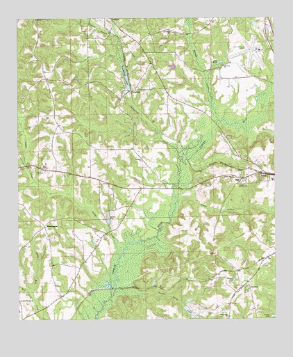
Youngblood, AL USGS Topographic Map
Click on map above to begin viewing in our Map Viewer.

This topographic map contains these locations and features:
Feature Name Type Latitude Longitude GNIS ID View Map
AllredPopulated PlaceN31.7718°W86.0083°139813View Map
Beeman CreekStreamN31.8327°W86.0272°113830View Map
Boyds Mill CreekStreamN31.8568°W86.0738°114794View Map
Carters PondReservoirN31.7921°W86.0809°115671View Map
Double BranchStreamN31.7990°W86.0475°117408View Map
Elam-RodgersLocaleN31.7890°W86.1125°117906View Map
Fishtrap BridgeBridgeN31.8043°W86.0472°139856View Map
Good HopePopulated PlaceN31.8171°W86.0647°139861View Map
Good Hope Baptist ChurchChurchN31.8163°W86.0647°119140View Map
Good Hope CemeteryCemeteryN31.8157°W86.0647°1805510View Map
Goshen-Shady Grove DivisionCivilN31.8554°W86.1092°165930View Map
Greene Hills Memorial CemeteryCemeteryN31.8068°W86.0149°119361View Map
Hales ChapelChurchN31.8132°W86.1127°164064View Map
Hales ChapelLocaleN31.8118°W86.1063°139864View Map
HephzibahPopulated PlaceN31.7654°W86.0130°119990View Map
Hephzibah Baptist ChurchChurchN31.7629°W86.0188°139871View Map
Hepzibah CemeteryCemeteryN31.7635°W86.0188°1730428View Map
Hillard and Howard CemeteryCemeteryN31.7660°W86.0486°163535View Map
Hinson CemeteryCemeteryN31.8090°W86.0136°163536View Map
Indian CreekStreamN31.7765°W86.0761°120642View Map
Israel CemeteryCemeteryN31.8460°W86.0733°163540View Map
Jordan CemeteryCemeteryN31.8160°W86.0469°163542View Map
Jordan CreekStreamN31.8252°W86.0547°139877View Map
Lake HavenReservoirN31.8566°W86.0265°119858View Map
Lebanon Baptist ChurchChurchN31.8471°W86.0547°139881View Map
Lees ParkPopulated PlaceN31.8557°W86.0263°139882View Map
Meadow GrovePopulated PlaceN31.7613°W86.0138°1730437View Map
Meadows CemeteryCemeteryN31.7524°W86.0233°163547View Map
Meeksville Volunteer Fire DepartmentBuildingN31.8668°W86.0023°163548View Map
Messick BranchStreamN31.8143°W86.1211°122673View Map
Mill CreekStreamN31.7585°W86.1175°122783View Map
Milton Carter DamDamN31.7902°W86.0816°129966View Map
Mount Zion CemeteryCemeteryN31.7532°W86.0319°123420View Map
Mount Zion ChurchChurchN31.7582°W86.1216°164086View Map
New Mount Zion ChurchChurchN31.7518°W86.0233°123872View Map
Oak Grove United Methodist ChurchChurchN31.8557°W86.0241°152729View Map
Old Lebanon ChurchChurchN31.8696°W86.0494°152783View Map
Pearson BranchStreamN31.8674°W86.0755°124552View Map
Pilgrims Rest Baptist ChurchChurchN31.8096°W86.0208°164098View Map
River RidgePopulated PlaceN31.8257°W86.0222°1730450View Map
Sims CemeteryCemeteryN31.8349°W86.1102°126881View Map
Springfield ChurchChurchN31.8749°W86.1161°127282View Map
Thomas ChapelChurchN31.8071°W86.0172°164134View Map
Thunder Spring CreekStreamN31.7615°W86.0688°127955View Map
Town and Country EstatesPopulated PlaceN31.7688°W86.0055°1730459View Map
Troy Municipal Airport at North Kenneth Campbell FieldAirportN31.8616°W86.0071°129414View Map
Whaleys PondReservoirN31.7661°W86.0203°128819View Map
Williams CemeteryCemeteryN31.7877°W86.0797°163576View Map
YoungbloodPopulated PlaceN31.8452°W86.0694°154053View Map
Youngblood CreekStreamN31.8152°W86.0461°154054View Map
Youngblood DamDamN31.8452°W86.0716°129990View Map
Youngblood LakeReservoirN31.8505°W86.0723°129315View Map

Note: Coordinates in the location and feature list above are referenced to NAD83 datum.


Copyright (C) 2008-2024 Ryan Niemi / Sunset Dynamics ... All Rights Reserved