TopoQuest Logo
Do you find TopoQuest useful?
Help keep TopoQuest running and adding new maps/features by donating!
Bitcoin:  19c7KJd3qBynnjoSw5npx9KScwjBe4ifkT
Litecoin:  LXs6TkuXGGXo1vDsWCkWVdjQX94eUKd6ui
Home View Maps Find Maps Find Places Resources & Links


Ansley, Alabama Topographic Map

USGS Map Title: Ansley, AL
USGS Map MRC: 31086H1
DRG (GeoTIFF) Download: o31086h1.tif


Neighboring USGS Topographic Map Quads:


  Ramer, AL  
32086A2
 

  Pine Level, AL  
32086A1
 

  China Grove, AL  
32085A8
 

  Grady, AL  
31086H2
 

  Ansley, AL  
31086H1
 

  Needmore, AL  
31085H8
 

  Petrey, AL  
31086G2
 

  Youngblood, AL  
31086G1
 

  Troy, AL  
31085G8


Map MRC Location:

N32°
W87°
N32°
W86°
H8 H7 H6 H5 H4 H3 H2 H1
G8 G7 G6 G5 G4 G3 G2 G1
F8 F7 F6 F5 F4 F3 F2 F1
E8 E7 E6 E5 E4 E3 E2 E1
D8 D7 D6 D5 D4 D3 D2 D1
C8 C7 C6 C5 C4 C3 C2 C1
B8 B7 B6 B5 B4 B3 B2 B1
A8 A7 A6 A5 A4 A3 A2 A1
N31°
W87°
N31°
W86°

Ansley, AL USGS 1:24K Topographic Map Preview:
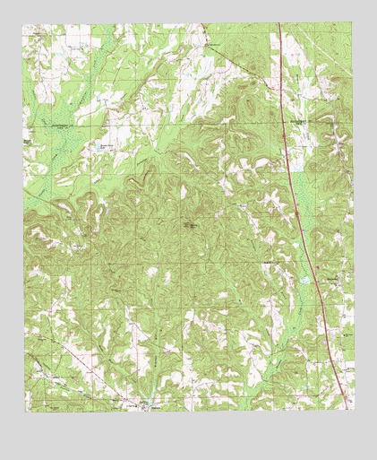
Ansley, AL USGS Topographic Map
Click on map above to begin viewing in our Map Viewer.

This topographic map contains these locations and features:
Feature Name Type Latitude Longitude GNIS ID View Map
AnsleyPopulated PlaceN31.8863°W86.1158°113096View Map
Ansley ChurchChurchN31.8874°W86.1147°139814View Map
Ansley SchoolSchoolN31.8788°W86.0913°113097View Map
Antioch CemeteryCemeteryN31.8757°W86.0811°1805536View Map
Antioch Church of ChristChurchN31.8757°W86.0805°139815View Map
Becks MountainSummitN31.9349°W86.0625°113784View Map
Belsor CemeteryCemeteryN31.9374°W86.1066°113900View Map
Bethel ChurchChurchN31.9490°W86.0008°139823View Map
Bethlehem ChurchChurchN31.9477°W86.0005°139825View Map
Brooks Farm LakeReservoirN31.9606°W86.0965°114963View Map
Center PointPopulated PlaceN31.9899°W86.0872°147755View Map
Center Point ChurchChurchN31.9927°W86.1066°115857View Map
CurryPopulated PlaceN31.9413°W86.0441°156243View Map
FriendshipPopulated PlaceN31.8785°W86.0041°163526View Map
Friendship ChurchChurchN31.8785°W86.0036°139858View Map
Greenbrier CreekStreamN31.9668°W86.1063°119360View Map
HarmonyPopulated PlaceN31.8911°W86.0039°139868View Map
Harmony ChurchChurchN31.8877°W86.0038°119750View Map
Harmony Elementary SchoolSchoolN31.8990°W86.0044°165443View Map
Jackson CreekStreamN31.9635°W86.1100°155115View Map
Little Patsaliga CreekStreamN31.9463°W86.1166°121837View Map
Macedonia ChurchChurchN31.9929°W86.0544°122152View Map
Macedonia School (historical)SchoolN31.9921°W86.0544°142682View Map
McQuagge Mill CreekStreamN31.8779°W86.0777°152289View Map
MeeksvillePopulated PlaceN31.9179°W86.0055°122631View Map
Menefee LakeReservoirN31.9626°W86.1249°122656View Map
Mill CreekStreamN31.8854°W86.0338°122764View Map
Mount Gilead CemeteryCemeteryN31.8990°W86.0069°139890View Map
Mount Moriah CemeteryCemeteryN31.9221°W86.0299°163550View Map
Mount Moriah ChurchChurchN31.9227°W86.0302°123251View Map
Mount Olive ChurchChurchN31.9160°W86.0066°123292View Map
Oak BoweryLocaleN31.9288°W86.1025°139896View Map
Oak Bowery Church of ChristChurchN31.9279°W86.1038°152720View Map
OrionPopulated PlaceN31.9588°W86.0055°152820View Map
Orion CemeteryCemeteryN31.9679°W86.0077°142776View Map
Orion ChurchChurchN31.9590°W86.0050°163553View Map
Orion ChurchChurchN31.9671°W86.0077°124303View Map
Orion Institute (historical)SchoolN31.9613°W86.0069°164487View Map
Pine Grove CemeteryCemeteryN31.8996°W86.1186°139909View Map
Pine Grove ChurchChurchN31.8993°W86.1180°124782View Map
Pine Hill ChurchChurchN31.9140°W86.0897°124815View Map
PisgahPopulated PlaceN31.9968°W86.1183°156904View Map
Pisgah ChurchChurchN31.9957°W86.1175°142801View Map
Saint James ChurchChurchN31.8782°W86.0022°139915View Map
Sanders CemeteryCemeteryN31.9310°W86.1177°126340View Map
ShellhornPopulated PlaceN31.8760°W86.0797°153403View Map
Shellhorn Junior High SchoolSchoolN31.8771°W86.0827°164206View Map
Shellhorn PondLakeN31.8775°W86.0777°126680View Map
Springfield CemeteryCemeteryN31.8751°W86.1141°127280View Map
Surveyors BranchStreamN31.8952°W86.0275°127568View Map

Note: Coordinates in the location and feature list above are referenced to NAD83 datum.


Copyright (C) 2008-2024 Ryan Niemi / Sunset Dynamics ... All Rights Reserved