TopoQuest Logo
Do you find TopoQuest useful?
Help keep TopoQuest running and adding new maps/features by donating!
Bitcoin:  19c7KJd3qBynnjoSw5npx9KScwjBe4ifkT
Litecoin:  LXs6TkuXGGXo1vDsWCkWVdjQX94eUKd6ui
Home View Maps Find Maps Find Places Resources & Links


Phelps, New York Topographic Map

USGS Map Title: Phelps, NY
USGS Map MRC: 42077H1
DRG (GeoTIFF) Download: o42077h1.tif


Neighboring USGS Topographic Map Quads:


  Palmyra, NY  
43077A2
 

  Newark, NY  
43077A1
 

  Lyons, NY  
43076A8
 

  Clifton Springs, NY  
42077H2
 

  Phelps, NY  
42077H1
 

  Geneva North, NY  
42076H8
 

  Rushville, NY  
42077G2
 

  Stanley, NY  
42077G1
 

  Geneva South, NY  
42076G8


Map MRC Location:

N43°
W78°
N43°
W77°
H8 H7 H6 H5 H4 H3 H2 H1
G8 G7 G6 G5 G4 G3 G2 G1
F8 F7 F6 F5 F4 F3 F2 F1
E8 E7 E6 E5 E4 E3 E2 E1
D8 D7 D6 D5 D4 D3 D2 D1
C8 C7 C6 C5 C4 C3 C2 C1
B8 B7 B6 B5 B4 B3 B2 B1
A8 A7 A6 A5 A4 A3 A2 A1
N42°
W78°
N42°
W77°

Phelps, NY USGS 1:24K Topographic Map Preview:
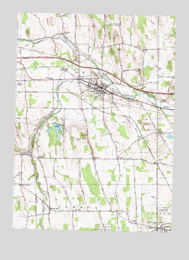
Phelps, NY USGS Topographic Map
Click on map above to begin viewing in our Map Viewer.

This topographic map contains these locations and features:
Feature Name Type Latitude Longitude GNIS ID View Map
Armstrong CemeteryCemeteryN42.9405°W77.0126°942569View Map
Burnett CemeteryCemeteryN42.9509°W77.0093°945226View Map
Butcher CemeteryCemeteryN42.8855°W77.0424°945337View Map
Church of the NazareneChurchN42.9611°W77.1053°2615772View Map
Countryside Mobile Home ParkPopulated PlaceN42.9235°W77.0379°2618214View Map
Day Brothers Dairy And Maple FarmLocaleN42.9222°W77.0147°2559136View Map
First Methodist ChurchChurchN42.9594°W77.0631°2400876View Map
First Presbyterian ChurchChurchN42.9569°W77.0547°2400875View Map
Five Waters CemeteryCemeteryN42.9881°W77.0929°2542279View Map
Five Waters CornersLocaleN42.9884°W77.0897°950209View Map
Flint CreekStreamN42.9609°W77.0494°970127View Map
Fort HillPopulated PlaceN42.9170°W77.0433°972493View Map
Grammar AirportAirportN42.8822°W77.0503°978033View Map
Hemdale FarmsLocaleN42.8972°W77.0967°2558869View Map
Joslyn CemeteryCemeteryN42.9290°W77.0257°954204View Map
Knickerbocker CornerPopulated PlaceN42.9620°W77.0961°972693View Map
Melvin HillPopulated PlaceN42.9167°W77.0625°956933View Map
Melvin Hill CemeteryCemeteryN42.9191°W77.0641°2542280View Map
Midlakes High SchoolSchoolN42.9567°W77.0977°2669232View Map
Midlakes Intermediate SchoolSchoolN42.9585°W77.1024°2669174View Map
Midlakes Middle SchoolSchoolN42.9577°W77.0980°2669175View Map
Midlakes Primary SchoolSchoolN42.9594°W77.1022°2668882View Map
Newark ReservoirReservoirN42.9328°W77.0922°958488View Map
Oak Lawn CemeteryCemeteryN42.9170°W77.0118°959136View Map
Oaks CornersPopulated PlaceN42.9323°W77.0125°959179View Map
Oaks Corners ChurchChurchN42.9353°W77.0119°2542281View Map
Oaks Corners Fire CompanyBuildingN42.9327°W77.0007°2700862View Map
OrleansPopulated PlaceN42.9187°W77.1144°959484View Map
Orleans CemeteryCemeteryN42.9176°W77.1194°2542275View Map
Pedersen FarmsLocaleN42.8883°W77.0764°2558872View Map
PhelpsPopulated PlaceN42.9576°W77.0575°960275View Map
Phelps Central SchoolSchoolN42.9597°W77.0619°2400870View Map
Phelps Fire DepartmentBuildingN42.9564°W77.0675°2700839View Map
Phelps JunctionPopulated PlaceN42.9676°W77.0864°972938View Map
Phelps Post OfficePost OfficeN42.9575°W77.0583°2618060View Map
Phelps Town HallBuildingN42.9572°W77.0572°2400874View Map
Phelps Village HallBuildingN42.9569°W77.0578°2400872View Map
Phelps Village Sewerage Treatment PlantLocaleN42.9606°W77.0508°2617747View Map
Pierson CornersLocaleN42.9001°W77.1189°960365View Map
Pinewood CemeteryCemeteryN42.9687°W77.0283°960585View Map
Pioneer CemeteryCemeteryN42.9590°W77.0634°2542278View Map
Pre-emptionPopulated PlaceN42.8778°W77.0164°961106View Map
Redfield CommonParkN42.9542°W77.0592°2400869View Map
Resthaven CemeteryCemeteryN42.9611°W77.0635°2542276View Map
Riverside Mobile Home ParkPopulated PlaceN42.9862°W77.1072°2618278View Map
Saint Francis CemeteryCemeteryN42.9625°W77.0629°2542277View Map
Saint Francis Roman Catholic ChurchChurchN42.9569°W77.0583°2400871View Map
Saint Johns Episcopal ChurchChurchN42.9564°W77.0578°2400873View Map
Saint Marys CemeteryCemeteryN42.8951°W77.0134°963902View Map
School Number 1 (historical)SchoolN42.9275°W77.0122°2364576View Map
School Number 11 (historical)SchoolN42.9886°W77.0792°2364580View Map
School Number 13 (historical)SchoolN42.9772°W77.0950°2364581View Map
School Number 15 (historical)SchoolN42.9608°W77.0981°2364582View Map
School Number 17 (historical)SchoolN42.9945°W77.0452°975140View Map
School Number 21 (historical)SchoolN42.9597°W77.0433°2364583View Map
School Number 3 (historical)SchoolN42.9453°W77.0133°2364577View Map
School Number 4 (historical)SchoolN42.8864°W77.0644°2364578View Map
School Number 7 (historical)SchoolN42.9353°W77.1078°2364579View Map
School Number 8 (historical)SchoolN42.8809°W77.0280°975595View Map
Seneca CastlePopulated PlaceN42.8870°W77.0961°964824View Map
Seneca Castle Fire DistrictBuildingN42.8866°W77.0916°2701044View Map
Seneca Castle Post OfficePost OfficeN42.8870°W77.0964°2618116View Map
Town of PhelpsCivilN42.9574°W77.0480°979361View Map
UnionvillePopulated PlaceN42.9517°W77.0375°968237View Map
Village of PhelpsCivilN42.9581°W77.0621°2391060View Map
Warner CornersLocaleN42.9162°W77.1055°968803View Map
Westfall CemeteryCemeteryN42.9692°W77.0133°970917View Map
Wheat CemeteryCemeteryN42.9225°W77.1071°970982View Map
Whitney CemeteryCemeteryN42.8867°W77.0742°971182View Map

Note: Coordinates in the location and feature list above are referenced to NAD83 datum.


Copyright (C) 2008-2025 Ryan Niemi / Sunset Dynamics ... All Rights Reserved