TopoQuest Logo
Do you find TopoQuest useful?
Help keep TopoQuest running and adding new maps/features by donating!
Bitcoin:  19c7KJd3qBynnjoSw5npx9KScwjBe4ifkT
Litecoin:  LXs6TkuXGGXo1vDsWCkWVdjQX94eUKd6ui
Home View Maps Find Maps Find Places Resources & Links


Bessemer, Pennsylvania Topographic Map

USGS Map Title: Bessemer, PA
USGS Map MRC: 40080H4
DRG (GeoTIFF) Download: o40080h4.tif


Neighboring USGS Topographic Map Quads:


  Campbell, OH  
41080A5
 

  Edinburg, PA  
41080A4
 

  New Castle North, PA  
41080A3
 

  New Middletown, OH  
40080H5
 

  Bessemer, PA  
40080H4
 

  New Castle South, PA  
40080H3
 

  East Palestine, OH  
40080G5
 

  New Galilee, PA  
40080G4
 

  Beaver Falls, PA  
40080G3


Map MRC Location:

N41°
W81°
N41°
W80°
H8 H7 H6 H5 H4 H3 H2 H1
G8 G7 G6 G5 G4 G3 G2 G1
F8 F7 F6 F5 F4 F3 F2 F1
E8 E7 E6 E5 E4 E3 E2 E1
D8 D7 D6 D5 D4 D3 D2 D1
C8 C7 C6 C5 C4 C3 C2 C1
B8 B7 B6 B5 B4 B3 B2 B1
A8 A7 A6 A5 A4 A3 A2 A1
N40°
W81°
N40°
W80°

Bessemer, PA USGS 1:24K Topographic Map Preview:
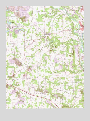
Bessemer, PA USGS Topographic Map
Click on map above to begin viewing in our Map Viewer.

This topographic map contains these locations and features:
Feature Name Type Latitude Longitude GNIS ID View Map
BessemerPopulated PlaceN40.9748°W80.4937°1213140View Map
Bessemer Boro Police DepartmentBuildingN40.9754°W80.4918°2780153View Map
Bessemer Post OfficePost OfficeN40.9754°W80.4918°2779658View Map
Bessemer Volunteer Fire Company Station 400BuildingN40.9753°W80.4943°2644884View Map
Borough of BessemerCivilN40.9756°W80.4879°1215351View Map
Borough of S.N.P.J.CivilN40.9298°W80.4978°2390560View Map
CovertsPopulated PlaceN40.9945°W80.4162°1203355View Map
Derringer CornersPopulated PlaceN40.9259°W80.4648°1173173View Map
Evans Airport (historical)AirportN40.9070°W80.4681°1194135View Map
Gwin Airport (historical)AirportN40.9564°W80.4853°1194144View Map
Hickory CreekStreamN40.9737°W80.4926°1176954View Map
Hickory CreekStreamN40.9737°W80.4926°1066748View Map
Hickory RunStreamN40.9578°W80.3798°1176975View Map
Jackson Knolls GardensPopulated PlaceN40.9545°W80.4278°1177921View Map
Kimmel Airport (historical)AirportN40.8834°W80.4831°1194127View Map
Lawrence JunctionPopulated PlaceN40.9678°W80.3778°1203994View Map
Little Beaver Police DepartmentBuildingN40.9001°W80.4636°2780260View Map
Madonna CemeteryCemeteryN40.9939°W80.3765°1180863View Map
Mahoning RiverStreamN40.9581°W80.3787°1066822View Map
MoraviaPopulated PlaceN40.9212°W80.3762°1181529View Map
Mount AirPopulated PlaceN40.9017°W80.4415°1204218View Map
Mount JacksonPopulated PlaceN40.9623°W80.4353°1181724View Map
Mount Jackson CemeteryCemeteryN40.9529°W80.4389°1181725View Map
North Beaver Township Police DepartmentBuildingN40.9659°W80.4285°2780270View Map
North Beaver Township Volunteer Fire Department Station 700BuildingN40.9629°W80.4349°2645331View Map
Reno AirportAirportN40.8894°W80.4877°1194131View Map
Shaw IslandIslandN40.9490°W80.3776°1187394View Map
Shenango RiverStreamN40.9581°W80.3787°1046180View Map
Sugar CreekStreamN40.9051°W80.4878°1188928View Map
SunnysidePopulated PlaceN40.9698°W80.4078°1189077View Map
Township of Little BeaverCivilN40.8786°W80.4636°1216655View Map
Township of North BeaverCivilN40.9475°W80.4466°1216658View Map
Turner Poultry FarmLocaleN40.8761°W80.4478°2725559View Map
Union Area High SchoolSchoolN40.9998°W80.3776°1205559View Map
Union Area Middle SchoolSchoolN40.9998°W80.3776°1211756View Map
Union Memorial Elementary SchoolSchoolN40.9992°W80.3776°1211757View Map
Valley View CemeteryCemeteryN40.9814°W80.3790°1190321View Map
WBZY-AM (New Castle)TowerN40.9395°W80.3937°1200466View Map
Westview HeightsPopulated PlaceN40.9967°W80.3765°1193647View Map
Willow GrovePopulated PlaceN40.9534°W80.3828°1191499View Map

Note: Coordinates in the location and feature list above are referenced to NAD83 datum.


Copyright (C) 2008-2024 Ryan Niemi / Sunset Dynamics ... All Rights Reserved