TopoQuest Logo
Do you find TopoQuest useful?
Help keep TopoQuest running and adding new maps/features by donating!
Bitcoin:  19c7KJd3qBynnjoSw5npx9KScwjBe4ifkT
Litecoin:  LXs6TkuXGGXo1vDsWCkWVdjQX94eUKd6ui
Home View Maps Find Maps Find Places Resources & Links


Pike Creek, Montana Topographic Map

USGS Map Title: Pike Creek, MT
USGS Map MRC: 47109A3
DRG (GeoTIFF) Download: o47109a3.tif


Neighboring USGS Topographic Map Quads:


  Brooks, MT  
47109B4
 

  New Year, MT  
47109B3
 

  Judith Peak, MT  
47109B2
 

  Lewistown, MT  
47109A4
 

  Pike Creek, MT  
47109A3
 

  Horsethief Coulee West, MT  
47109A2
 

  Castle Butte, MT  
46109H4
 

  Heath, MT  
46109H3
 

  Loco Ridge, MT  
46109H2


Map MRC Location:

N48°
W110°
N48°
W109°
H8 H7 H6 H5 H4 H3 H2 H1
G8 G7 G6 G5 G4 G3 G2 G1
F8 F7 F6 F5 F4 F3 F2 F1
E8 E7 E6 E5 E4 E3 E2 E1
D8 D7 D6 D5 D4 D3 D2 D1
C8 C7 C6 C5 C4 C3 C2 C1
B8 B7 B6 B5 B4 B3 B2 B1
A8 A7 A6 A5 A4 A3 A2 A1
N47°
W110°
N47°
W109°

Pike Creek, MT USGS 1:24K Topographic Map Preview:
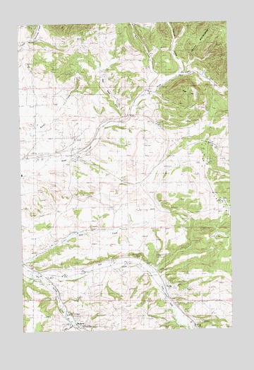
Pike Creek, MT USGS Topographic Map
Click on map above to begin viewing in our Map Viewer.

This topographic map contains these locations and features:
Feature Name Type Latitude Longitude GNIS ID View Map
14N19E01CBAD01 WellWellN47.0027°W109.2627°820076View Map
14N19E05CAA_01 SpringSpringN47.0026°W109.3435°820080View Map
14N19E05DBC_01 SpringSpringN47.0011°W109.3421°820057View Map
14N19E05DBCC01 SpringSpringN47.0014°W109.3418°820064View Map
15N19E08ACCA01 WellWellN47.0786°W109.3416°820604View Map
15N19E08CCBA01 WellWellN47.0733°W109.3516°820569View Map
15N19E08DCCA01 WellWellN47.0719°W109.3421°820551View Map
15N19E08DDA_01 WellWellN47.0725°W109.3338°820556View Map
15N19E09BABC01 WellWellN47.0830°W109.3271°820629View Map
15N19E17BABD01 WellWellN47.0697°W109.3457°820544View Map
15N19E17BBA_01 WellWellN47.0691°W109.3505°820541View Map
15N19E18CBBD01 WellWellN47.0619°W109.3738°820499View Map
15N19E24BC__01 WellWellN47.0494°W109.2652°820404View Map
15N19E25BDAB01 WellWellN47.0364°W109.2591°820331View Map
15N19E26BCBC01 WellWellN47.0355°W109.2880°820325View Map
15N19E30CCDA01 WellWellN47.0272°W109.3702°820253View Map
15N19E32CCC_01 WellWellN47.0136°W109.3510°820147View Map
15N19E35ACCB01 WellWellN47.0200°W109.2780°820198View Map
15N19E35BDBD01 WellWellN47.0205°W109.2813°820203View Map
15N19E35DACB01 WellWellN47.0161°W109.2727°820162View Map
15N19E35DBBC01 WellWellN47.0172°W109.2774°820176View Map
16N19E31CAA_01 WellWellN47.1044°W109.3668°820749View Map
16N19E34ADCA01 WellWellN47.1064°W109.2927°820769View Map
16N19E34ADCD01 WellWellN47.1053°W109.2938°820763View Map
16N19E34B___01 WellWellN47.1089°W109.3049°820798View Map
Big SpringSpringN47.0025°W109.3435°805774View Map
Blind Breed GulchValleyN47.0841°W109.3155°769027View Map
Box Springs (historical)Populated PlaceN47.0050°W109.3466°1722778View Map
Boyd Creek School (historical)SchoolN47.0711°W109.3560°1722656View Map
Brown Coal MineMineN47.0508°W109.2538°769261View Map
Castle CreekStreamN47.0027°W109.3446°781021View Map
Corbley School (historical)SchoolN47.0786°W109.3555°1722657View Map
Corbly (historical)Populated PlaceN47.0789°W109.3563°1722797View Map
Divide Coal MineMineN47.0675°W109.2646°770668View Map
DunlapLocaleN47.0166°W109.2885°805836View Map
East Fork Big Spring CreekStreamN47.0202°W109.3616°782806View Map
Hansen CreekStreamN47.0036°W109.3460°778804View Map
Heath StationLocaleN47.0144°W109.2916°772299View Map
Judith School (historical)SchoolN47.1055°W109.3116°1722661View Map
Kelly HillSummitN47.0978°W109.2721°772970View Map
Kiwanis CampLocaleN47.0994°W109.2638°773095View Map
Limekiln CanyonValleyN47.1189°W109.3646°773346View Map
Pike CreekStreamN47.0264°W109.3746°775221View Map
Pike Creek DamDamN47.0350°W109.3507°796691View Map
Pyramid CreekStreamN47.1030°W109.2768°775499View Map
Ruby GulchValleyN47.0961°W109.2971°775994View Map
Ruby Gulch (historical)Populated PlaceN47.1119°W109.2971°1722908View Map
Ruby School (historical)SchoolN47.1036°W109.2924°775997View Map
Skaggs Coal MineMineN47.0664°W109.2552°776604View Map

Note: Coordinates in the location and feature list above are referenced to NAD83 datum.


Copyright (C) 2008-2025 Ryan Niemi / Sunset Dynamics ... All Rights Reserved