TopoQuest Logo
Do you find TopoQuest useful?
Help keep TopoQuest running and adding new maps/features by donating!
Bitcoin:  19c7KJd3qBynnjoSw5npx9KScwjBe4ifkT
Litecoin:  LXs6TkuXGGXo1vDsWCkWVdjQX94eUKd6ui
Home View Maps Find Maps Find Places Resources & Links


Waco, North Carolina Topographic Map

USGS Map Title: Waco, NC
USGS Map MRC: 35081C4
DRG (GeoTIFF) Download: o35081c4.tif


Neighboring USGS Topographic Map Quads:


  Lawndale, NC  
35081D5
 

  Cherryville, NC  
35081D4
 

  Lincolnton West, NC  
35081D3
 

  Shelby, NC  
35081C5
 

  Waco, NC  
35081C4
 

  Bessemer City, NC  
35081C3
 

  Blacksburg North, SC  
35081B5
 

  Grover, NC  
35081B4
 

  Kings Mountain, NC  
35081B3


Map MRC Location:

N36°
W82°
N36°
W81°
H8 H7 H6 H5 H4 H3 H2 H1
G8 G7 G6 G5 G4 G3 G2 G1
F8 F7 F6 F5 F4 F3 F2 F1
E8 E7 E6 E5 E4 E3 E2 E1
D8 D7 D6 D5 D4 D3 D2 D1
C8 C7 C6 C5 C4 C3 C2 C1
B8 B7 B6 B5 B4 B3 B2 B1
A8 A7 A6 A5 A4 A3 A2 A1
N35°
W82°
N35°
W81°

Waco, NC USGS 1:24K Topographic Map Preview:
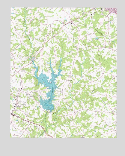
Waco, NC USGS Topographic Map
Click on map above to begin viewing in our Map Viewer.

This topographic map contains these locations and features:
Feature Name Type Latitude Longitude GNIS ID View Map
Beam School (historical)SchoolN35.3512°W81.4690°1985950View Map
Beulah ChurchChurchN35.3087°W81.4295°981266View Map
Buffalo ChurchChurchN35.3257°W81.4712°982158View Map
Capernaum Baptist ChurchChurchN35.3551°W81.4395°1986121View Map
Capernaum CemeteryCemeteryN35.3557°W81.4398°1985910View Map
Cleveland Community College Emergency Services Regional Training CenterBuildingN35.2760°W81.4887°2639575View Map
Cleveland County Emergency Medical Services Station 3BuildingN35.2761°W81.4884°2720417View Map
Cleveland County Emergency Medical Services Station 8BuildingN35.3607°W81.4323°2720416View Map
Cleveland County FairgroundsLocaleN35.2812°W81.4884°1001531View Map
Cleveland County Home (historical)LocaleN35.2801°W81.4926°1985938View Map
Cleveland County Office BuildingBuildingN35.2815°W81.4937°1007739View Map
Cleveland County Technical InstituteLocaleN35.2804°W81.4920°1001533View Map
Cleveland MallLocaleN35.2671°W81.4806°1001534View Map
Cleveland Spring (historical)Populated PlaceN35.2771°W81.4962°1001537View Map
Crossroads Music ParkParkN35.2651°W81.4284°1007752View Map
Elizabeth CemeteryCemeteryN35.2904°W81.4920°1985911View Map
Elizabeth ChurchChurchN35.2899°W81.4918°1000747View Map
Elizabeth CityPopulated PlaceN35.2929°W81.4912°1001543View Map
Elizabeth SchoolSchoolN35.2799°W81.4940°984693View Map
Emmanuel ChurchChurchN35.3368°W81.3837°984773View Map
Fairview FarmsLocaleN35.3001°W81.4768°1007751View Map
Fancy (historical)Populated PlaceN35.3085°W81.3940°1001549View Map
First Assembly of God ChurchChurchN35.2724°W81.4812°1986118View Map
Friendship ChapelChurchN35.3276°W81.4895°985429View Map
Hendricks LakeReservoirN35.3749°W81.4973°998889View Map
Hendricks Lake DamDamN35.3735°W81.4965°998890View Map
HolbrookPopulated PlaceN35.2846°W81.4934°1005958View Map
Holy Memorial ChurchChurchN35.2612°W81.4673°986990View Map
Hullender CemeteryCemeteryN35.3085°W81.3929°987237View Map
Jerusalem ChurchChurchN35.2921°W81.4787°987586View Map
Kennedy LakeReservoirN35.3693°W81.4976°998887View Map
Kennedy Lake DamDamN35.3701°W81.4965°998888View Map
Kings Mountain ReservoirReservoirN35.2817°W81.4558°988007View Map
LandsdownPopulated PlaceN35.2937°W81.4654°1001568View Map
Light OakPopulated PlaceN35.2849°W81.4768°1867431View Map
Light Oak Census Designated PlaceCensusN35.2867°W81.4774°2403232View Map
Light Oak ChurchChurchN35.2899°W81.4776°988472View Map
Little Persimmon CreekStreamN35.2851°W81.4195°988728View Map
Long CreekStreamN35.3290°W81.4770°988958View Map
Marys GrovePopulated PlaceN35.3407°W81.3831°1021362View Map
Marys Grove ChurchChurchN35.3621°W81.3793°989427View Map
Masonic LodgeLocaleN35.2896°W81.4937°1007740View Map
Mays ChurchChurchN35.3354°W81.3793°1985946View Map
Moss DamDamN35.2768°W81.4565°998723View Map
Moss LakeReservoirN35.2768°W81.4565°998724View Map
Muddy ForkStreamN35.2596°W81.4565°990765View Map
Muddy Fork (historical)LocaleN35.3174°W81.4154°1001571View Map
New Camp Creek ChurchChurchN35.2807°W81.4451°990950View Map
New ProspectPopulated PlaceN35.3496°W81.4781°1986122View Map
New Prospect CemeteryCemeteryN35.3485°W81.4784°1985913View Map
New Prospect ChurchChurchN35.3485°W81.4795°991079View Map
North Carolina State Highway DepartmentLocaleN35.2815°W81.4937°1007738View Map
North Carolina State Highway Patrol Troop H District 4BuildingN35.2662°W81.4822°2769923View Map
Oak Grove Baptist ChurchChurchN35.2754°W81.4215°1986120View Map
Oak Grove Volunteer Fire DepartmentBuildingN35.2782°W81.4116°2638331View Map
OakgrovePopulated PlaceN35.2732°W81.4245°991467View Map
Persimmon CreekStreamN35.2846°W81.4256°992062View Map
Plank School (historical)SchoolN35.3132°W81.3862°1985952View Map
Potts CreekStreamN35.2612°W81.4537°992756View Map
Rhyne School (historical)SchoolN35.3174°W81.4265°1985953View Map
Roberts School (historical)SchoolN35.2810°W81.4706°1985954View Map
Rock Cut School (historical)SchoolN35.3137°W81.4856°1985955View Map
Saint Luke Church (historical)ChurchN35.3110°W81.3804°1985948View Map
Shelby Fire Department Station 3BuildingN35.2760°W81.4884°2639038View Map
South SchoolSchoolN35.3718°W81.3756°995212View Map
Stony PointPopulated PlaceN35.3051°W81.4326°995578View Map
StubbsPopulated PlaceN35.3271°W81.4712°1022821View Map
Suck CreekStreamN35.3396°W81.4745°995638View Map
Town of WacoCivilN35.3617°W81.4287°2406810View Map
WacoPopulated PlaceN35.3615°W81.4287°996655View Map
Waco Baptist ChurchChurchN35.3643°W81.4293°1986127View Map
Waco Community Volunteer Fire DepartmentBuildingN35.3609°W81.4317°2638322View Map
Waco High SchoolSchoolN35.3599°W81.4281°1986128View Map
Waco Post OfficePost OfficeN35.3621°W81.4283°2773940View Map
Ware Bridge (historical)LocaleN35.2557°W81.4587°1001590View Map
Warlick Township 5 (historical)CivilN35.3193°W81.4309°1026564View Map
Washington ChurchChurchN35.3376°W81.4212°996825View Map
Washington SchoolSchoolN35.3357°W81.4215°996831View Map
Whiteoak CreekStreamN35.3274°W81.4404°997236View Map
WoodbridgePopulated PlaceN35.2893°W81.4384°1001596View Map
Woodbridge Golf CourseLocaleN35.2937°W81.4406°1001597View Map

Note: Coordinates in the location and feature list above are referenced to NAD83 datum.


Copyright (C) 2008-2024 Ryan Niemi / Sunset Dynamics ... All Rights Reserved