TopoQuest Logo
Do you find TopoQuest useful?
Help keep TopoQuest running and adding new maps/features by donating!
Bitcoin:  19c7KJd3qBynnjoSw5npx9KScwjBe4ifkT
Litecoin:  LXs6TkuXGGXo1vDsWCkWVdjQX94eUKd6ui
Home View Maps Find Maps Find Places Resources & Links


Pine Crest, Missouri Topographic Map

USGS Map Title: Pine Crest, MO
USGS Map MRC: 37091A6
DRG (GeoTIFF) Download: o37091a6.tif


Neighboring USGS Topographic Map Quads:


  Eunice, MO  
37091B7
 

  Summersville, MO  
37091B6
 

  Summersville NE, MO  
37091B5
 

  Clear Springs, MO  
37091A7
 

  Pine Crest, MO  
37091A6
 

  Jam Up Cave, MO  
37091A5
 

  Trask, MO  
36091H7
 

  Mountain View, MO  
36091H6
 

  Montier, MO  
36091H5


Map MRC Location:

N38°
W92°
N38°
W91°
H8 H7 H6 H5 H4 H3 H2 H1
G8 G7 G6 G5 G4 G3 G2 G1
F8 F7 F6 F5 F4 F3 F2 F1
E8 E7 E6 E5 E4 E3 E2 E1
D8 D7 D6 D5 D4 D3 D2 D1
C8 C7 C6 C5 C4 C3 C2 C1
B8 B7 B6 B5 B4 B3 B2 B1
A8 A7 A6 A5 A4 A3 A2 A1
N37°
W92°
N37°
W91°

Pine Crest, MO USGS 1:24K Topographic Map Preview:
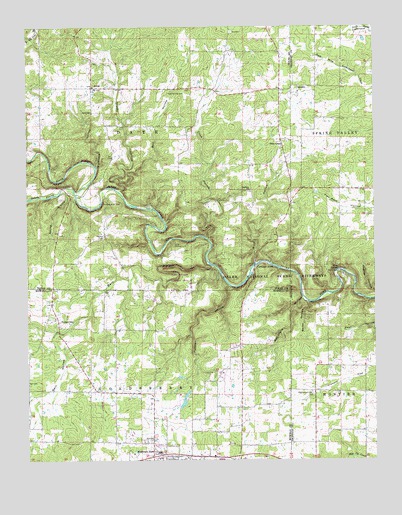
Pine Crest, MO USGS Topographic Map
Click on map above to begin viewing in our Map Viewer.

This topographic map contains these locations and features:
Feature Name Type Latitude Longitude GNIS ID View Map
ArrollPopulated PlaceN37.1076°W91.7265°713401View Map
Arroll SchoolSchoolN37.1003°W91.7265°713402View Map
Baptizing HoleBarN37.0539°W91.6343°737935View Map
Barn HollowValleyN37.0556°W91.6832°713660View Map
Barn Hollow Natural AreaParkN37.0528°W91.6951°742861View Map
Belew HollowValleyN37.0451°W91.6493°713890View Map
Bell CemeteryCemeteryN37.1234°W91.6765°713898View Map
Bell HollowValleyN37.0801°W91.7160°713912View Map
Bell SchoolSchoolN37.1176°W91.6785°747775View Map
Blue SpringSpringN37.0548°W91.6382°714425View Map
Blue Spring CampsiteParkN37.0545°W91.6382°741419View Map
Blue Spring River AccessLocaleN37.0545°W91.6382°741421View Map
Blue SpringsLocaleN37.0539°W91.6376°735957View Map
Bluff View River AccessLocaleN37.0531°W91.6399°741418View Map
Buck HollowValleyN37.0562°W91.6685°714967View Map
Buck Hollow River AccessLocaleN37.0562°W91.6676°741417View Map
Buckhorn HollowValleyN37.0845°W91.7251°714981View Map
Cardinal AcresPopulated PlaceN37.0553°W91.6685°715392View Map
Chimney RockCliffN37.0717°W91.7288°735341View Map
Chimney Rock SpringSpringN37.0748°W91.7229°735342View Map
Cold Spring CemeteryCemeteryN37.1056°W91.6932°716082View Map
Columbia SchoolSchoolN37.0378°W91.7404°747777View Map
Coon HollowValleyN37.0634°W91.6851°716267View Map
Ferndale Church (historical)ChurchN37.0378°W91.7040°747778View Map
Gill BranchStreamN37.0559°W91.6826°735079View Map
Grassy HollowValleyN37.0781°W91.7165°718725View Map
Harlow CemeteryCemeteryN37.0639°W91.7226°719099View Map
Harlow FordPopulated PlaceN37.0723°W91.7051°740906View Map
Harlow SchoolSchoolN37.0639°W91.7229°747776View Map
Heelstring SchoolSchoolN37.0267°W91.6401°747781View Map
Hickory FlatFlatN37.0231°W91.6357°719452View Map
Hines SchoolSchoolN37.0223°W91.6826°747782View Map
Inwood SchoolSchoolN37.0781°W91.6296°747780View Map
McCubbin HollowValleyN37.0462°W91.6510°722069View Map
Mercy Saint Francis HospitalHospitalN37.0023°W91.7030°2655017View Map
North Prong Jacks ForkStreamN37.0762°W91.7324°754221View Map
OaksidePopulated PlaceN37.1073°W91.6524°741113View Map
Oakside CemeteryCemeteryN37.1053°W91.6523°2702947View Map
Oakside Community ChurchChurchN37.1062°W91.6522°2702948View Map
Oakside SchoolSchoolN37.1145°W91.6371°747779View Map
Panther HollowValleyN37.0501°W91.6779°723996View Map
Pilgrim Rest ChurchChurchN37.0189°W91.6488°724342View Map
Pine CrestPopulated PlaceN37.0920°W91.6588°724376View Map
Ratcliff FordPopulated PlaceN37.0562°W91.6843°741187View Map
South Prong Jacks ForkStreamN37.0762°W91.7324°754223View Map
Stallman SchoolSchoolN37.0776°W91.6699°726997View Map
Township of DateCivilN37.0933°W91.7087°767467View Map
Township of GoldsberryCivilN37.0070°W91.7239°766784View Map
TurnervillePopulated PlaceN37.0406°W91.7393°727910View Map
VFW CampgroundLocaleN37.0626°W91.6985°728093View Map

Note: Coordinates in the location and feature list above are referenced to NAD83 datum.


Copyright (C) 2008-2025 Ryan Niemi / Sunset Dynamics ... All Rights Reserved