TopoQuest Logo
Do you find TopoQuest useful?
Help keep TopoQuest running and adding new maps/features by donating!
Bitcoin:  19c7KJd3qBynnjoSw5npx9KScwjBe4ifkT
Litecoin:  LXs6TkuXGGXo1vDsWCkWVdjQX94eUKd6ui
Home View Maps Find Maps Find Places Resources & Links


Pine Valley, Georgia Topographic Map

USGS Map Title: Pine Valley, GA
USGS Map MRC: 31082B5
DRG (GeoTIFF) Download: o31082b5.tif


Neighboring USGS Topographic Map Quads:


  Axson, GA  
31082C6
 

  Talmo, GA  
31082C5
 

  Dixie Union, GA  
31082C4
 

  Cogdell, GA  
31082B6
 

  Pine Valley, GA  
31082B5
 

  Waycross West, GA  
31082B4
 

  Homerville East, GA  
31082A6
 

  Manor, GA  
31082A5
 

  Waycross SW, GA  
31082A4


Map MRC Location:

N32°
W83°
N32°
W82°
H8 H7 H6 H5 H4 H3 H2 H1
G8 G7 G6 G5 G4 G3 G2 G1
F8 F7 F6 F5 F4 F3 F2 F1
E8 E7 E6 E5 E4 E3 E2 E1
D8 D7 D6 D5 D4 D3 D2 D1
C8 C7 C6 C5 C4 C3 C2 C1
B8 B7 B6 B5 B4 B3 B2 B1
A8 A7 A6 A5 A4 A3 A2 A1
N31°
W83°
N31°
W82°

Pine Valley, GA USGS 1:24K Topographic Map Preview:
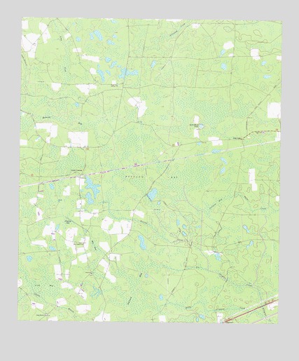
Pine Valley, GA USGS Topographic Map
Click on map above to begin viewing in our Map Viewer.

This topographic map contains these locations and features:
Feature Name Type Latitude Longitude GNIS ID View Map
Bennett BaySwampN31.2088°W82.6088°311081View Map
Big Alligator CreekStreamN31.1288°W82.5076°311290View Map
Camp Branch ChurchChurchN31.1274°W82.6104°312200View Map
Church of God of ProphecyChurchN31.1273°W82.6106°2502157View Map
Crews CrossingPopulated PlaceN31.1858°W82.5951°331478View Map
Cribb BaySwampN31.1403°W82.6142°313118View Map
Footlog BaySwampN31.1822°W82.5582°314253View Map
Gator Head PondLakeN31.2063°W82.5381°314537View Map
Little Alligator CreekStreamN31.1291°W82.5074°316929View Map
Long PondSwampN31.2308°W82.6040°317386View Map
New Prospect ChurchChurchN31.1574°W82.5938°319498View Map
Pine ValleyPopulated PlaceN31.2013°W82.5185°326471View Map
Pine Valley ChurchChurchN31.2044°W82.5115°320650View Map
Pittman BaySwampN31.1749°W82.5299°320757View Map
Rice PondSwampN31.1560°W82.5876°321561View Map
Stallard BaySwampN31.1358°W82.5701°323499View Map
Stalsby CreekStreamN31.1472°W82.5337°323501View Map
Steedley BaySwampN31.1664°W82.6006°323552View Map
WXGA-TV (Waycross)TowerN31.2216°W82.5732°352871View Map
WXVS-FM (Waycross)TowerN31.2216°W82.5732°352821View Map
Zenith ChurchChurchN31.1452°W82.5893°325661View Map

Note: Coordinates in the location and feature list above are referenced to NAD83 datum.


Copyright (C) 2008-2025 Ryan Niemi / Sunset Dynamics ... All Rights Reserved